Download
1 / 13
170 likes | 433 Views
Do you want to learn more about the surveying equipment? We have compiled a list of the six most commonly used surveying tools. Are you interested in surveying instruments? Falcon Geomatics LLC offers survey equipment accessories, stocking accessories with the highest quality surveying accessories from different manufacturers and many others besides. <br><br>Visit: https://www.falcon-geosystems.com/product-category/equipment-accessories/ <br><br>

E N D
6 Most Frequently Used Surveying Instruments
Land surveys date back to ancient Roman times, making surveying one of the oldest professions. You might think that ancient surveying equipment was rudimentary and crude, but evidence shows that ancient measuring tools were developed with surprising accuracy. Surveying instruments have evolved in response to exponential technological advancements since then. Surveyors nowadays use advanced electronic equipment as well as more basic tools to aid in measuring and mapping efforts.
Do you want to learn more about the surveying equipment? We have compiled a list of the six most commonly used surveying tools, which include: 01 02 Measuring tape Theodolite 03 04 3D Scanners Total station 05 06 Level and rod GPS/GNSS
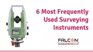
01. Theodolite Theodolite is a surveying instrument with a rotating telescope for measuring horizontal and vertical angles and triangulating the position of objects in a specific area.
02. Measuring tape A length of the tape or thin flexible metal that has been marked at intervals to measure size or distance. Surveyors frequently use tape measures (also known as measuring wheels) in lengths greater than 100 meters.
03 3D scanners A surveying tool capable of accurately measuring and collecting data from objects, surfaces, buildings, and landscapes. This tool gathers data in the form of point cloud data, which is made up of millions of 3D coordinates. These coordinates can be used to generate 3D computer-aided design (CAD) models that can be used to analyse topographic features and structures. The high accuracy of 3D scanners contributes to lower project costs.
04. Total station A theodolite with an on-board computer that collects data and performs triangulation calculations and uses electronics to calculate angles and distances. This tool is used in topographic surveying to record features or to mark out features (roads, houses, or boundaries).
05. GPS/GNSS The use of Global Positioning System and/or Global Navigation Satellite System signals through a receiver and antenna to determine the form, boundary, position, objects, or points in space in relation to other forms, boundaries, or points. Surveyors’ speed and productivity have increased dramatically as a result of this technology, which uses on-demand centimeter-level accuracy provided by Real-Time Kinematic (RTK) positioning.
06. Level and Rod A graduated wooden or aluminium rod used in conjunction with a levelling instrument to determine the height difference between two points or the heights of two points above a vertical datum. This tool is used to determine and validate elevations.
Read More: https://medium.com/@falcongeosystem/6-m ost-frequently-used-surveying-instruments-b6 089ed2859c
Surveying is essential for the building of new roads and structures required to meet the needs of our people. Surveying engineers employ a variety of tools to collect the data needed to map, chart, and measure. Are you interested in surveying instruments? Falcon Geomatics LLC offers survey equipment accessories, stocking accessories with the highest quality surveying accessories from different manufacturers and many others besides. They have all models of Prisms and Detail Poles, Chargers, Batteries and Chartwell Books. For more information contact now.
Contact Details: Address: Ahammed Kamal Warehouse 6 Street 10C, Ras al Khor Industrial 1, PO.Box.238544 Dubai, United Arab Emirates Phones: +971 4 327 9333 +971 4 2299555 Emails: sales@falcon-geosystems.com service@falcon-geosystems.com