Download
1 / 1
10 likes | 111 Views
Detailed analysis of two tornadic thunderstorms occurring in ostensibly weak deep layer shear environments in Colorado. The study discusses forecasting challenges and discrepancies in storm motion predictions.

E N D
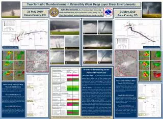
Two Tornadic Thunderstorms in Ostensibly Weak Deep Layer Shear Environments John Monteverdi, San Francisco State University Michael Umscheid, National Weather Service, Dodge City, KS Evan Bookbinder, National Weather Service, Kansas City, MO 25 May 2010 Kiowa County, CO 31 May 2010 Baca County, CO Lifespan as a supercell: 5.5 hours Lifespan as a supercell: 4 hours KGLD 2225 UTC 0.5 ° Reflectivity KGLD 2225 UTC 0.5 ° Storm Relative Velocity KPUX 2105 UTC 0.5 ° Reflectivity KPUX 2105 UTC 0.5 ° Storm Relative Velocity 2000 UTC Surface Analysis • Kinematic Forecasting Issues Related to Both Cases • Use of Bulk Shear – The assessment of the vertical wind shear environment using Bulk Shear, popularized by numerous objective analysis schemes (such as Storm Prediction Center “mesoanalysis” page), can underestimate the actual vertical shear in environments with strongly looped hodographs. Total shear (or more specifically “positive” shear in clockwise looped hodographs) over a defined layer is a better tool, especially over deeper layers (i.e. 0-6 km). • 500 mb Winds – As a mandatory level in the middle troposphere, severe storms forecasters tend to use 500 mb winds as a “first guess” in assessing the deep layer shear environment and subsequent potential for rotating storms. This is also near the top of the popular 0-6 km Bulk Shear layer. Areas with generally weaker 500 mb winds tend to attract less attention than other areas with stronger mid-upper tropospheric flow (all else being equal), and thus further scrutiny of the environment may not be done. • Storm Motion using Bunkers Method – The Bunkers Method for prediction of deviant storm motion works generally well for classical hodograph shapes associated with supercell storms. Actual storm motion has been found in some cases (including the two presented here) to differ quite a bit from Bunkers Method prediction – particularly those cases that involve weaker overall mid-upper tropospheric flow and substantial curvature of the lower tropospheric hodograph. This affects many objective analysis fields that are storm-motion sensitive, such as storm-relative helicity and storm-relative anvil-level flow. KGLD 2315 UTC 0.5 ° Reflectivity KGLD 2315 UTC 0.5 ° Storm Relative Velocity KPUX 0005 UTC 0.5 ° Reflectivity KPUX 0005 UTC 0.5 ° Storm Relative Velocity 2000 UTC Surface Analysis Baca County Storm (31 May) Phase 1: 1730-2025 (175 min.) Non-supercellular phase of the storm which comprised of several updraft iterations as it slowly moved east at an average forward motion of 5 kts (~2.5 m s-1) or less. Two distinct funnel clouds (Photo A) were observed at 1954 and 2002 about 7 km west of Pritchett, CO. Phase 2: 2025-2210 (105 min.) Beginning of supercell phase as Updraft C4 became dominant. The storm moved due south from 350 to 360° at 5 kts (~2.5 m s-1) or less and produced a long-lived, significant tornado (Photos B and C, rated EF-2) south of Pritchett. Phase 3: 2210-0155 (225 min.) The supercell moved from a fairly constant 295° at 15 kts (~7.5 m s-1) and produced another long-lived, significant tornado (Photo E, rated EF-2) during this phase south of Campo. Several other shorter-lived tornadoes also occurred. KGLD 2352 UTC 0.5 ° Reflectivity KGLD 2352 UTC 0.5 ° Storm Relative Velocity KAMA 0016 UTC 0.5 ° Reflectivity KAMA 0016 UTC 0.5 ° Storm Relative Velocity Kiowa County Storm (25 May) Phase 1: 2125-2200 (35 min.) Non-supercellular phase of the storm in which 8 to 10 tornadoes (Photos A and B) occurred south of Towner, CO. Mean storm motion was from 164° at 13 kts (~6.5 m s-1) . Phase 2: 2200-2330 (90 min.) Beginning of supercell phase as storm interacts with a slow-moving synoptic front. Impressive radar velocity couplet at 2225 with possible tornado. Well-documented short-lived tornado (Photo C) at 2315 about 27 km northwest of Tribune. Mean storm motion varied from 165° initially to 220° toward the end of this phase at 12 kts (~6 m s-1) . Phase 3: 2330-0200 (150 min.) Began with the emergence of Updraft “T4” at 2330, which became the longest-lived updraft and produced at least a couple tornadoes (Photos D and E) during this time frame. Mean storm was a fairly constant 260° at 20 kts (~10 m s-1) and closer to predicted Bunkers storm motion. 1200 UTC KDDC Radiosonde 1200 UTC KAMA Radiosonde 2000 UTC RUC13 Towner, Colorado 2000 UTC RUC13 Campo, CO 0000 UTC RUC13 Towner, Colorado For a list of references, please see the extended abstract at http://ams.confex.com/ams/pdfpapers/175862.pdf