Download
1 / 16
170 likes | 480 Views
Global transport and radiative forcing of biomass burning aerosols . Yang Chen, Qinbin Li, Ralph Kahn Jet Propulsion Laboratory California Institute of Technology, Pasadena Evan Lyons, James Randerson University of California, Irvine. The 3rd GEOS–Chem Users' Meeting

E N D
Global transport and radiative forcing of biomass burning aerosols Yang Chen, Qinbin Li, Ralph Kahn Jet Propulsion Laboratory California Institute of Technology, Pasadena Evan Lyons, James Randerson University of California, Irvine The 3rd GEOS–Chem Users' Meeting Harvard University, April 12, 2007
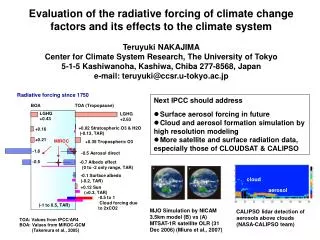
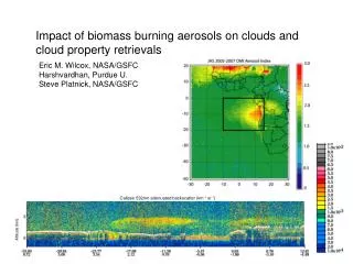
Objectives and outline • Large uncertainties in the estimation of aerosol radiative forcing. • -0.1~-0.9 W/m2 for direct forcing (IPCC,2007). • -0.3~-1.8 W/m2 for indirect forcing. • Purpose: Combine satellite observations and chemical transport models to further constrain quantification of aerosol (particularly the biomass burning aerosols) radiative forcing. • First step: Estimate the global aerosol direct radiative effect using Multi-angle Imaging SpectroRadiometer (MISR) observations. • Better aerosol retrievals over land. • First attempt at estimating aerosol direct radiative effect on a global basis (over both ocean and land) using satellite observation based approach. • Ongoing modeling study: GEOS-Chem simulations of aerosols using different GFEDv2 biomass burning emissions. • Diurnal cycles • Synoptic variation • Injection height
Introduction to MISR • Multi-angle multi-channel spectroradiometer on board satellite TERRA • Global Mode: • 275 m sampling resolution for nadir camera and red band of other cameras • 1.1 km for the other channels • 400-km swath • Global coverage: 9 days at equator, 2 days at poles • Continuous data retrieval since Feb 2000. • Major products used: • TOA albedo (2.2x2.2 km2) • AOD (17.6x17.6 km2) • Cloud mask (1.1x1.1 km2) • BHRPAR (1.1x1.1 km2) • All products are re-sampled to 17.6x17.6 km2 for this study
Method MISR observations Nadir view Cloud mask TOA Broadband Albedo (with aerosol) Aerosol Optical Depth Albedo ~ AOD regression AOD TOA albedo Cloud mask BHRPAR 1°x 1° grid
Global distribution of AOD, albedo, and BHRPAR (July, 2002) 26 BHRPAR bins: 0~0.1: each 0.01 interval 0.1~0.4: each 0.02 interval Above 0.4: 1 level
e a d g b c f Albedo~AOD correlation over ocean Albedo~AOD correlation for 10°x5° grids. The slopes indicate the ability of aerosols to affect TOA radiative flux. Alternative method: do global regression for each solar zenith angle.
Albedo~AOD correlation over land Albedo~AOD correlation for 10°x5° grids A C A East US B B Central Africa Global correlation C Saharan desert
Aerosol direct radiative effect (a) (b) (a) Clear-sky and (b) all-sky aerosol direct radiative effect (W/m2) for July 2002.
Aerosol direct radiative effect From this study (July, 2002): From previous satellite-based studies:
Uncertainties • Satellite retrieval of aerosol, albedo and surface properties. • Cloud contamination. • Diurnal variability. • TOA albedo narrow-to-broadband conversion. • Surface heterogeneity.
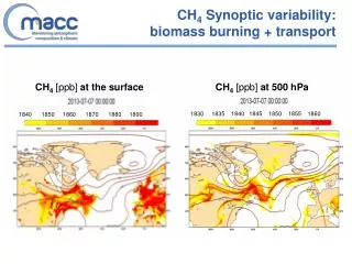
Ongoing modeling study Diurnal cycle effect on GEOS-Chem aerosol simulation • Simulation conditions • Model: GEOS-Chem v7-03-06 • Meteorology: GEOS-4 • Simulation type: Offline aerosol simulation • Simulation period: 06/2004 ~ 08/2004 • Biomass burning emissions: Global Fire Emissions Database version 2 (GFEDv2) with 8 day time interval • with diurnal cycle • without diurnal cycle 07/2004
Ongoing modeling study Diurnal cycle effect on Central Africa C emissions Local noon BCPI concentration difference(with diurnal cycle - without) With diurnal cycle, major emissions occur when the PBL is high. The vertical mixing causes faster dilution and the dissipation of pollutants. The accumulation of aerosols during local night is weaker.
Ongoing modeling study Diurnal cycle effect on Alaska and Northern Canada Emissions from source: C emissions Local noon BCPI concentration difference(with diurnal cycle - without) BCPI concentration in nearby grid: When the biomass burning emission is very strong and PBL is low, the dissipation effect is weaker. For some regions near the strong source, the transport is more important than the local emission.
Conclusions and future work • Conclusions • By using MISR datasets, first satellite-based attempt to estimate global aerosol direct radiative effect over both ocean and land has been made. • Aerosols have different impacts on TOA albedo in different regions due to different aerosol properties and surface types. • Global mean result of aerosol radiative effect over ocean is well in the range of other studies in literature. • By including diurnal cycle of biomass burning emissions in GEOS-Chem simulation, aerosol concentrations at surface may increase or decrease, depending on the source type and intensity, the boundary layer height, and the relative importance of transport and local emissions. • Future work • Extend the satellite-based estimation of aerosol direct radiative effect to include seasonal and inter-annual variability. • Study how synoptic variability of biomass burning emissions and the inclusion of smoke injection height will affect the global distribution of aerosols, and the implication to the aerosol radiative forcing.
Acknowledgment • MISR data were obtained from the NASA Langley Atmospheric Sciences Data Center (http://eosweb.larc.nasa.gov/). • We used Global Fire Emissions Database version2 (van der Werf et al.,2006) resampled to an 8day time step using MODIS fire hot spots (Giglio et al., 2003). • GEOS-Chem model is managed by the Atmospheric Chemistry Modeling Group at Harvard University.