NOGAPS:
Snow Cover. Low Clouds. Cloud Top Altitudes in Kilofeet. High Clouds. Oil Tanker Attack Off Yemen Coast. Low Clouds at Night. Smoke Plume. Tanker Location. Aircraft Contrails. 9-km COAMPS TM 48-h forecast valid 00 UTC 26 Mar 2003. Dust Front.

NOGAPS:
E N D
Presentation Transcript
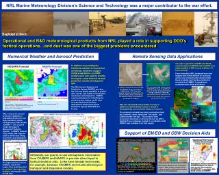
Snow Cover Low Clouds Cloud Top Altitudes in Kilofeet High Clouds Oil Tanker Attack Off Yemen Coast Low Clouds at Night Smoke Plume Tanker Location Aircraft Contrails 9-km COAMPSTM 48-h forecast valid 00 UTC 26 Mar 2003 Dust Front COAMPS 6-hr Forecast of Duct Base Height (m) COAMPSTM dust erodible fraction Iraq Surface dust concentration (mg m-3) Target Acquisition Weather System (TAWS) New targets added for OIF at customer request. NRL aerosol research aimed at improving information about weather effects on EO propagation. Surface stress (m/s) and 10-m streamlines Ducting products help the Fleet predict locations where they might encounter extended signal ranges or radar holes based upon atmospheric conditions forecast by COAMPSTM. NRL Marine Meteorology Division’s Science and Technology was a major contributor to the war effort. Baghdad at Noon Operational and R&D meteorological products from NRL played a role in supporting DOD’s tactical operations…and dust was one of the biggest problems encountered. Numerical Weather and Aerosol Prediction Remote Sensing Data Applications Through cooperation of NASA and NOAA, research data from MODIS and SeaWIFS were made available to NRL in near-real time (1-3 hours latency). From those data, NRL produced true-color imagery and enhancements for dust and smoke over land and water and provided those products over the Secure Internet connection at FNMOC to operational customers both afloat and ashore. In addition to providing the traditional weather forecasts that are always needed to support military operations, our NWP models were also used to provide forcing for a new breed of aerosol prediction models developed at NRL. The NRL Aerosol Analysis and Prediction System (NAAPS) provides the first-ever global capability to predict dust, smoke, and sulfate concentration, movement, and dissipation. NAAPS requires databases for initializing the aerosol source regions, and it uses forecast fields from the Navy Atmospheric Global Operational Prediction System (NOGAPS) for forcing. NAAPS Forecast NOGAPS Forecast The corresponding enhancement, highlighting areas of significant dust as shades of bright pink and orange, provides a markedly improved sensitivity and level of detail to the many dust features present in the scene A massive dust storm fans through the Margow desert of southern Afghanistan. This true color imagery example demonstrates the inherent difficulties in identifying the details of dust via analysis of unenhanced imagery NOGAPS: Top color scale – Terrain height in meters Lower color scale – Surface frictional velocity (cm/s) Barbs – Surface wind direction and speed (m/s) Dashed lines – Ground Wetness NAAPS: Surface Dust Concentration (ug-m**3) NRL also developed and provided a variety of additional satellite data products to assist in distinguishing environmental features of interest. The products included low cloud, convective cloud top, contrails, snow, smoke and “hot spots”, and satellite/model overlays. The products were presented collectively on Secure Internet via NRL’s Satellite Focus webpage, hosted in coordination with FNMOC and available to all DoD assets. NRL’s mesoscale aerosol prediction capability is embedded directly into our high-resolution nested nonhydrostatic NWP model COAMPS™ (the Coupled Ocean/Atmosphere Mesoscale Prediction System). COAMPS fields at every model time step are used to define dust lifting, movement, and dissipation. Support of EM/EO and CBW Decision Aids Hypothetical HPAC Forecast of Anthrax Surface Dosage 13 hours after release Ultimately, our goal is to use atmospheric information from COAMPS and NAAPS to provide direct input to tactical decision aids. Links have already been made, for example, between COAMPS and chemical/biological transport and dispersion models. The high-resolution source database required to support this modeling effort is a unique 1-km resolution database developed by NRL for SW Asia. Atmospheric forcing is provided by COAMPS-OnScene run with an inner nest at 1-km resolution. COAMPS-OS™ is a portable, GUI-based version of COAMPS.