Download

1 / 18
180 likes | 282 Views
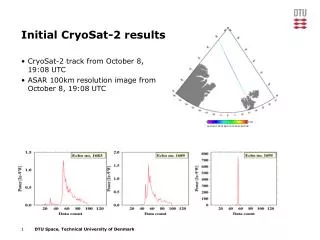
Increasing the accuracy of Arctic gravity field modelling using Cryosat-2 SAR altimetry. Ole B. Andersen, L. Stenseng and J. Maulik. Outline. Brief about satellite altimetry What Cryosat offers ”Mode jumps” The Baffin Bay test. Retracking of Cryosat-2 SAR Towards DTU12. Gravity field.

E N D
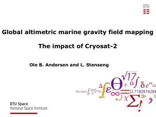
Increasing the accuracy of Arctic gravity field modelling using Cryosat-2 SAR altimetry. Ole B. Andersen, L. Stenseng and J. Maulik
Outline • Brief about satellite altimetry • What Cryosat offers • ”Mode jumps” • The Baffin Bay test. • Retracking of Cryosat-2 SAR • Towards DTU12
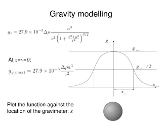
Gravity field Gravity field Gravity field sea mount The Sea surface height mimicks the geoid MSS = Geoid + Mean Dynamic Topography (MDT) Gravity from MDT corrected MSS (=Geoid)
Cryosat Offers a factor of two in SSH accuracy -> Should improve gravity substantially. 1.5 years ESA L2 and L1B analysed
SAR-In SAR LRM Hawaii
18 Hz Cryosat LRM SAR SAR-In 2011 V 2.1 2012 V 2.4 Large ”jumps” at mode shift Different between processors SOUTH North
Baffin Bay • Interestingbecauseitspartlyicecovered. • Thisenablescomparison C2 SAR and LRM
Cryosat SAR + LRMEntire 2011LRM mode (summer)SAR mode (winter)
Retracking of Cryosat-2 50% Th- reshold LE OCOG OCOG Experimenting with 5 retrackers on Level 1b SAR waveform (black) Entire waveform: OCOG + 5 parameter beta retracker with exponential tail (blue) and threshold retracking. Leading Edge retracking - OCOG and threshold retracking (50% for SAR, 75% for SarIn) (Se Poster XY348 by M. Jain today)
Retracking 20 Hz SAR dataonly SSH data in leads used. Std (ESA) = 36 cm Std (Leading Edge OCOG) = 22 cm
Marine Gravity. 6696 datapoints used Within 67N to 75N 55W to 65 W
Gravity comparison Identical parameter set to DTU10 for gravity comparison. No finetuning yet.
DTU 2012 Beta Coastal regions heavily improved Including CRYOSAT LRM data (ESA L2 vs NOAA) Including CRYOSAT SAR data Currently testing Cryosat SAR-IN Needs to adjust ”mode jumps” Updating all existing GM data. Particularly Ocean tide correction to GOT 4.7 Also SSB correction updated (na for Cryosat-2). Aim to release DTU12 at ”20 years of progress” in september 2012
DTU 2012 Beta Coastal regions heavily improved Preliminary testing using 1.6 years of NOAA C2 LRM Data
Summary Employes a Ph.d on retracking. Succesful retracking of SAR data. Trying SAR-IN now. This is certainly work in progress and we are really on the way Current Cryosat 2 data are comparable to existing GM altimetry Need to await new Cryosat 2 and the back processing. Will take time Rumours that Jason-1 will be changed to Geodetic Mission, but this will only improve up to 66N (no Arctic here).