Download
1 / 44
440 likes | 589 Views
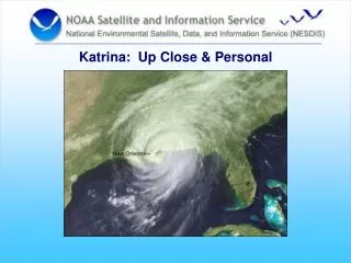
Assessing Katrina’s Impact on the Mississippi Gulf Coast: A Report on Research in Progress. David A. Swanson Department of Sociology & Anthropology University of Mississippi* dswanson@olemiss.edu *Photos by Dr. Ann Marie Kinnell, University of Southern Mississippi.

E N D
Assessing Katrina’s Impact on the Mississippi Gulf Coast: A Report on Research in Progress David A. Swanson Department of Sociology & Anthropology University of Mississippi* dswanson@olemiss.edu *Photos by Dr. Ann Marie Kinnell, University of Southern Mississippi
Assessing Katrina’s Impact • Clearly, Katrina impacted the United States, but it is difficult to get an accurate idea of even the most basic numbers – people, housing, businesses – for affected areas, particularly in a timely manner • Differences between Red Cross estimates and preliminary estimates I produced for south Mississippi are on the order of 25 percent • Ole Miss received $96,212 Fast Track NSF Grant to collect data for a study of Katrina’s impacts • Among other products, the NSF data will support an empirical estimate of housing and population effects in the Mississippi Gulf Coast area at the epicenter of Katrina’s impact
Assessing Katrina’s Impact • The Research Project involves demography, economics, political science, and sociology • It is testing a hypothesis that examines the effect of involvement in social networks on a person’s response to the impact of Katrina, all else equal • In collecting the data needed to examine this hypothesis, the study team will also have data on housing units and the number of them that were damaged.
Assessing Katrina’s Impact • The Data Collection Plan • Full enumeration “short form” and sample “ long form” • Traditional, block by block enumeration • Stratified Cluster Sample Selection using blocks as Primary Sampling Units
Assessing Katrina’s Impact Seven Phases • Field checking of maps in November 2005 • Pilot study, 7 January 2006 • Long form data collection was done over the period from January 8th to 14th • Long form mail-back follow-ups, January 8thth to February 15th • Short form data collection was done over the period from March 13th to 21st • Initial database construction in April and May • GIS development and analysis over the summer
Assessing Katrina’s Impact • Long form data collection team included faculty and graduate students form Ole Miss and people from Gulf Coast • Training at Ole Miss before Pilot Study (and Pilot Study served as OJT) • Distressed Population – on staff a Clinical Psychologist and Mental Health R.N. • General Human Subjects training for all on Project and special training and materials for this project
Assessing Katrina’s Impact • From short (and long form data) We can compare housing unit counts we collect with Census 2000 data on a block-by-block basis and, accounting for (most) change between census 2000 and August 29th 2005 • This gives empirical numbers for the absolute and relative numbers of total houses that were destroyed and damaged by type of housing unit.
Assessing Katrina’s Impact • We also counted temporary living units and have them located by site (e.g., in a FEMA park, on a slab, and next to a damaged house) • With the long form data and 2000 census data we can develop person per household (PPH) estimates by type of unit (e.g., permanent- single unit ; permanent-multiple unit; temporary)
Assessing Katrina’s Impact • We can apply the PPH estimates to the occupied housing stock to get population estimates for the entire study area (and its tracts) which will yield estimated changes from census 2000 due to Katrina • With the total population estimates, we can then inflate the characteristics data (e.g., age-sex, and race) from the long form to develop estimates of these characteristics for the entire population in the study area
Assessing Katrina’s Impact • Using 2000 census block level data we can compare (e. g, by block group) our block level sample data to our estimates; we also can post-stratify our results using the census 2000 data. • These estimates all have a solid empirical and methodological foundation that can provide a wealth of data about the post 2000 population in the study area before and after Katrina. • The difference between our post Katrina data and Census 2000 allow us to estimate the impact of Katrina in terms of housing, population and, demographic, social, and economic characteristics of the population in the study area.
Assessing Katrina’s Impact • The housing counts and corresponding total population estimates also can be compared with estimates (e.g., those developed from aerial and satellite imagery) developed using various data and assumptions • This comparison can be used to develop ideas about the magnitude and components of errors in these estimates, with an eye toward improving them in the future.
Assessing Katrina’s Impact Results to-date • Study Area: portions of two census tracts in Hancock County (030100 and 030200)and four in Harrison County (027000, 028000, 029000, & 030000): Epicenter of Katrina’s Landfall in Mississippi • 573 census blocks • 120 sampled for “long form” questionnaire • 425 completed “long form” questionnaires • Quality assessment of data and preliminary tabulations underway
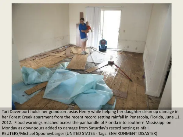
The Imperial Palace Casino in Biloxi before Katrina: The only lodging available for our study team in January, and where our rooms served as offices
Assessing Katrina’s Impact Preliminary Results (80 Long Form Blocks) 2006 Gulf Coast Survey Total Destroyed Vacant Occupied Housing Housing Housing Housing Units/SitesUnits/SitesUnitsUnits 1893 1199 343 351 (100%) (63%) (18%) (19%)
Assisted Living Center on US Hwy 90 Horizontal line represents high water mark, about 11 feet
Easterbrook Horizontal line represents high water mark, about 5 feet
Assessing Katrina’s Impact Example from Tract 030200, Block 1044 (Bay St. Louis) Permanent Units Total Destroyed Damaged Habitable Occupied Housing Housing Housing Housing Housing Units/SitesUnits/SitesUnits Units Units 7 1 6 0 0 (100%) (100%) (0%)(0%) (0%) Three Occupied Temporary Units (@ HU sequence #s 1a, 3a, and 7a) (see “green stars” in Block 1044 on close-up image, two slides from here)
Assessing Katrina’s Impact Example from Tract 030200, Block 1052 (Bay St. Louis) 2006 Gulf Coast Survey Total Destroyed Occupied Housing Housing Housing Units/SitesUnits/SitesUnits 7 7 0 (100%) (100%) (0%)
Assessing Katrina’s Impact Example from Tract 030200, Block 1044 (Bay St. Louis) Permanent Units Total Destroyed Damaged Habitable Occupied Housing Housing Housing Housing Housing Units/SitesUnits/SitesUnits Units Units 7 1 6 0 0 (100%) (100%) (0%)(0%) (0%) Three Occupied Temporary Units (@ HU sequence #s 1a, 3a, and 7a) (see “green stars” in Block 1044 on close-up image, two slides from here)
Assessing Katrina’s Impact Remaining Phases • Initial database construction in April and May • GIS development and analysis over the summer
Assessing Katrina’s Impact Proposed work (new NSF Proposal) Interdisciplinary $480,000 Submitted 21 February 2006 NSF decision expected in May
Project 3 Sociology Project 4 Economics Project 2 Psychology 2006 NSF Gulf Coast Survey Project 5 Political Science Project 1 Demography Project 6 Dissemination Assessing Katrina’s Impact Outline of Proposed work under NSF Proposal of February 21st