Download
1 / 15
150 likes | 299 Views
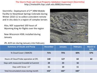
The Storm Peak Lab Cloud Property Validation Experiment (StormVEx). http://meteo04.chpc.utah.edu:8080/stormvex/. View Looking Southeast.

E N D
The Storm Peak Lab Cloud Property Validation Experiment (StormVEx) http://meteo04.chpc.utah.edu:8080/stormvex/ View Looking Southeast StormVEx: Deployment of 2nd ARM Mobile Facility to Steamboat Springs Colorado during Winter 2010-11 to collect coincident remote and in situ data in a region of complex terrain. Also, NSF supported 100 hours of Wyoming King Air flights over the region New Wisconsin HSRL installed during January JPL ACR ran during January into February Christie Peak (Aerosol Observing System) Valley Floor • Notes: • AMF2 Instrumentation up > 95% of time • HSRL installed at Thunderhead 1/10
The objectives of StormVEx are to, 1. Collect a continuous correlative remote sensing and in situ data set for development and validation of cloud and precipitation property retrieval algorithms in a mixed phase environment. 2. Produce an ACRF data set in a region of complex terrain - a long standing goal of ARM 3. Document the role of aerosols, both natural and anthropogenic, in cloud and precipitation microphysical processes.
Valley Floor Site – Everything too big and heavy to get to Thunderhead…
Table 2.2 Thunderhead Instruments • Purpose: Mid Mountain Remote Sensing – Basic ARM Ground-based Instrumentation Package. 2.4 km lateral and 500 m below SPL in situ sensors. • Primary Instruments • Scanning W-Band Cloud Radar (SWACR) • Micro Pulse Lidar (MPL) • High Spectral Res. Lidar (HSRL) • Atmos Emitted Radiance Interferometer (AERI) • Microwave Radiometer (MWR) • Multi-Filter Rot Shadowband (MFRSR) • SURF Rad – Pyranometers, pyrgeometers, etc • Infra Red Surface Temperature (IRT)
Storm Peak Lab Instrumentation consists primarily of in situ aerosol, cloud, and precipitation probes Additional instruments include SPEC CPI and 2DS
The Colorado Airborne Multi-Phase Cloud Study (CAMPS) NSF Funded (led by Linnea Avalone) deployment of the Wyoming King Air for flights over SPL. 100 hours from mid December through late February Instruments: In situ cloud,precipitation and remote sensing (radar and lidar).
StormVEx Completed Data Collection on 24 April 2011! • Continuous AMF2 data collected since late November . No major failures… • Meteorological conditions have provided a widely varied sample during a near record snow year. • Near daily operations of the cloud and aerosol probes at Storm Peak Lab • NSF CAMPS flight campaign exceeded goals.
Identifying Cloud and Precip with SWACR Spectra SWACR Spectra Animation of a gently snowing stratus layer…. Precipitation Mode Cloud Mode East-West RHI Jan. 12, 2011 19:45 UTC Storm Peak
The Storm Peak Lab Cloud Property Validation Experiment (StormVEx) Documenting Snowflake Orientation Sensitivity in W-Band Backscatter RHI toward SPL >5 db enhancement when 2d particles are observed in quiescent conditions. cm Snow Captured at Storm Peak Lab at 1930 UTC
SWACR RHI towards the SPL SLDR dendrite case 11-Feb-11 1649 UTC SLDR column case 4-Mar-11 0349 UTC Courtesy: Sergey Matrosov
Slant linear depolarization ratio (SLDR) trends with pointing angle at constant altitude allow differentiation between planar crystals (e.g., dendrites) and columnar crystals dendrites columns Courtesy: Sergey Matrosov