Download
1 / 12
120 likes | 141 Views
Learn to read topographic maps, understand contour lines, and delineate watersheds through engaging quiz slides with helpful hints and guidance.

E N D
How to Read a Topographic Map and Delineate a Watershed QuizI-1 View this quiz as a slide show from “the beginning” During the slide show, you can right click on any slide and choose pointer options then pen or highlighter to write on any slide. But you will need to right click & choose pointer options then arrow before you can click on any of the navigation links again.
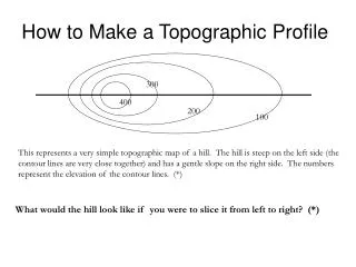
I-1-1 What does each contour line on a topographic map represents? a ground elevation or vertical distance above a reference point such as sea level. Sorry, no hint. Hint Answer Next Slide
I-1-2 The difference in elevation between two adjacent contours is called the _____________________________. contour interval Sorry, no hint. Hint Answer Next Slide
I-1-3 The horizontal distance between contours is determined by the ___________________________of the landscape. steepness Sorry, no hint. Hint Answer Next Slide
This topographic map represents an ______________. Mark the direction of waterflow. I-1-4 Isolated hill Sorry, no hint. Hint Answer Next Slide
I-1-5 A general rule of thumb is that water flow is ____________________ to contour lines. perpendicular Another word for right angle. Hint Answer Next Slide
This topographic map represents a ______________________. Add arrows to show direction of water flow. I-1-6 saddle What would you use on a horse?. Hint Answer Next Slide
I-1-7 A general rule of thumb is that topographic lines always point _______________ upstream Up or down-stream Hint Answer Next Slide
Draw the watershed boundaries & river flowing from points A to point B on this contour map. I-1-8 • Water flow is perpendicular to contour lines. • Topographic lines always point upstream. Hint Answer Next Slide
I-1-9 What are the four steps to delineating a watershed? Draw a circle at the outlet or downstream point of the wetland in question Put small "X's" at the high points along both sides of the watercourse, working your way upstream towards the headwaters of the watershed. Starting at the circle that was made in step one, draw a line connecting the "X's" along one side of the watercourse. This line should always cross the contours at right . Continue the line until it passes around the head of the watershed and down the opposite side of the watercourse. Eventually it will connect with the circle from which you started. No hint Hint Answer Next Slide
Delineate a Watershed on this topo map for the wetland marked with the o. I-1-10 Delineating a Watershed 1. Draw a circle at the outlet or downstream point of the wetland in question (the wetland is the hatched area) – This step was done for you. 2. Put small "X's" at the high points along both sides of the watercourse, working your way upstream towards the headwaters of the watershed. 3. Starting at the circle that was made in step one, draw a line connecting the "X's" along one side of the watercourse. This line should always cross the contours at right . 4. Continue the line until it passes around the head of the watershed and down the opposite side of the watercourse. Eventually it will connect with the circle from which you started. Hint Answer Next Slide
I-1-11 What are two widely available methods for measuring the area of a watershed? Dot Grid Method Planimeter. No hint Hint Answer Last Slide