Download

1 / 19
200 likes | 1.2k Views
Post presentation comments are in green. Age dating MAPCIS (Massive Australian Precambrian/Cambrian Impact Structure). A multi-modal indirect approach Daniel P. Connelly 2009. You will find background at MAPCIS.net.

E N D
Post presentation comments are in green Age dating MAPCIS(Massive Australian Precambrian/Cambrian Impact Structure) A multi-modal indirect approach Daniel P. Connelly 2009 You will find background at MAPCIS.net or at the GSA northeastern meeting March 2009 uploaded files, MAPCIS the Case for a Massive Australian Precambrian/Cambrian Impact Structure
Original Ring Discovery 2007 Discovery Vs Theory This discovery starts the search. The search leads to new discoveries. New discoveries propagate theories.
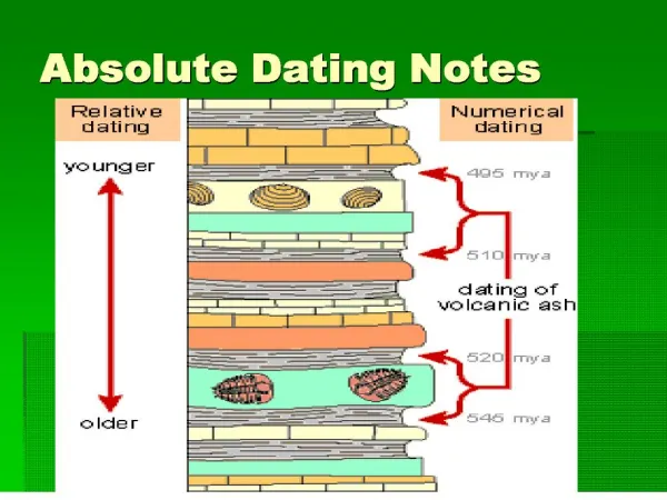
~545 Ma D. P. Connelly 2009
Impact ConstraintsAcraman Gosse Bluff 590Ma 142Ma 800km & 200km from MAPCIS center Ejecta from Acraman does not cover MAPCIS undisturbed Rain over Gosse Bluff 2/2008
Alice Springs Orogeny Constraint ~450Ma Deposited during Petermann orogeny Uplifted during Alice Springs Orogeny Mt. Currie Conglomerate Mutijulu Arkose,i Ayers Rock
Basement consistent with age? This map is used as an example of the many 1:250,000 Geology maps used to cross check basement ages by examining exposed outcrops. Although this 1954 map conforms with the 2008 GA Mafic Ultramafic map, there is considerable debate on the accuracy of these maps in this region. Neoproterozoic ridges Kangaroo Island
MAFIC Events and MAPCIS Dating Basic plate tectonics: When multiple events are divided, look for the youngest event to estimate the date of division. 13 29 11 10 MGr Moorilyanna Graben ~550Ma ME29 Skipworth Event ~575 ME 26 Gairdner Event ~825 A26 Amata dyke swarm G26 Gairdner dyke swarm ME16 Curramulka Event ~1590 ME13 Woman in White Event ~1680 ME 11 Lunch Creek Event ~1750 ME10 Hart Event ~1780 ME 9 Mount Hay Event ~1810Ma 9 TasmanGap 26 MGr 16 9 A26 10 11 29 13 26 16 G26 Derived from
Musgrave = Grenville age zircons Zircon age diagram of suspected post impact proximal ejecta deposits Worldwide Cambrian SS Enigma Arenite Distal Grenville Age zircons Feldspar local A. Camacho et Al. 2002 Musgrave Provence = Impact Center Over 120,000 Sq. Km The enigma is solved, if one has a huge impact in the center of a Grenville Aged province. This is what appears to have happened. Arkose Conglomerate P/C Boundary
Seven smaller impacts possibly coeval withMAPCIS A cross check of impact age databases found this grouping of possibly coeval impacts, that appears to be associated with the predicted impact trajectory noted in dark blue .
Foelsche ~545Ma and Bukalara SS Bukalara SS with shocked clasts blends into extensive regional unit. Antrim Plateau Volcanics (Kalkarindji LIP) ~510-545Ma Cover unlithified Bukalara SS After impact rapid burial Infers a rapid sequence of impact, fill, and coverage by basalt. Now P.W. Haines &D.J. Rawlings 2001
MAPCIS Center Overview • Trajectory Northeast to Southwest • Radial Transpression Ridges ? Visible on 1:250, 000 Geology maps • PT Arcuate & Radial light blue From Ayers Rock 1:250,000 Geology Map 2002 Largest known Pseudotachylite deposits, similar to Vredefort and Sudbury impacts. Neoproterozoic Winnall, Inindia & Pinyinna beds of Mt. Conner appear to be missing from MAPCIS Center.
Mt. Frazer Radial Pseudotachylite Edgoose CJ, Scrimgeour IR, Close DF 2003 Geology of the Musgrave Block, NT, NT Geological Survey Report 15 An example of PT not associated with a major fault.
Sampling Data from NT Geological Survey There appears to be no attempt to date the pseudotachylite itself
Sample sites plotted on Google Earth Sample B549 Derived from Edgoose CJ, Scrimgeour IR, Close DF 2003 Geology of the Musgrave Block, NT, NT Geological Survey Report 15 Mt. Frazer
Sample B54930km North of Mann Range pseudotachylite Notable that these zircons have a metamorphic peak at 561ma +- 11, and zircon 13 exhibits a mosaic pattern. Mosaic patterns in zircons has been associated with shock metamorphism.
Cumulative probability diagram of biotite ages for entire Musgrave Provence Camacho et al., 2002 Inferred that all fault systems in the Musgrave Provence were activated during the the Petermann Orogeny. 120,000 square Km moved here and portions were exhumed from 40km deep. Camacho et al., 2002
Conclusions • 1. Precambrian Basement underlies all visible parts within the outer ring. • 2. No known Precambrian impacts within 600km radius. • 3. Ejecta from Acraman 590Ma does not overlay MAPCIS ejecta. • 4. Gosse Bluff 142Ma and Alice Springs Orogeny structures are undisturbed. • 5. Lower Cambrian layers, proximal and distal exhibit a Musgrave fingerprint. • 6. Neoproterozoic beds appear to be missing from impact center. • 7 . Moorilyanna Graben forms and the Tasman Gap opens syn-orgenic with Petermann Orogeny • 8. Cambrian Bukalara SS fills and preserves Foelsche impact ~545mya. • 9. Mass extinction of Ediacarans in Australia occurs at the end of Precambrian. • 10. Dating of monazite and zircons nearest to pseudotachylite gives dates close to 545mya. MAPCIS probably occurred just before the Precambrian/ Cambrian Boundary. Further research is needed to refine this dating.