Download
1 / 2
20 likes | 101 Views
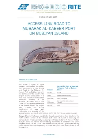
The projectu2019s scope of work involves construction, completion and maintenance of the Access Link Road to the Mubarak Al-Kabeer Port, on Bubiyan Island in the North East of the Country. <br><br>Encardio Rite carries a futuristic approach, providing instrumentation monitoring services globally for large Civil Construction Projects.

E N D
ONE STOP MONITORING SOLUTIONS | HYDROLOGY | GEOTECHNICAL | STRUCTURAL | GEODETIC Over 50 years of Excellence through ingenuity PROJECT DOSSIER ACCESS LINK ROAD TO MUBARAK AL-KABEER PORT ON BUBIYAN ISLAND PROJECT OVERVIEW The project’s scope of work involves construction, completion and maintenance of the Access Link Road to the Mubarak Al- Kabeer Port, on Bubiyan Island in the North East of the Country. The project covers construction of a 7 km road network including other associated facilities, Mubarak Al-Kabeer Port’s first phase to the present road network in the Bubiyan Island. The project also includes construction of reclamation and dredging of the service harbour and construction access, berth, link channel and access channel. Access Link Road to Mubarak Al-Kabeer Port, on Bubiyan Island Project Location Kuwait Client Ministry of Public Works Contractor Menard Vibro ME to link Sub- Contractor Gulf Inspection International Company Duration 2022 and quay entails wall, Bubiyan Island is the largest island in the Kuwaiti coastal island chain situated in the north-western corner of the Persian Gulf. State of Kuwait is improving its transportation infrastructure by developing world class Mubarak Al-Kabeer Port on Bubiyan Island, to manage the increasing movements of containers and other freight in and out of the Kuwait. The seaport will also provide a gateway for moving goods northwards to its neighboring countries that do not have direct access to the Arabian Gulf. www.encardio.com
MONITORING SOLUTION The monitoring instrumentation played a key role in accessing the lateral movements, settlements and the change in water level and pore pressure taking place during the construction. The monitoring data allowed the stakeholders to continuously assess the safety of the infrastructure being constructed as well the ones in the vicinity of construction. ENCARDIO-RITE’S ROLE Encardio-rite instrumentation required for the project. The geotechnical and geodetic instruments used in the project mainly included piezometers, inclinometers, and settlement points. Their location and purpose is briefly discussed below. Encardio- rite Geosystems, UAE was closely involved in the execution of the instrumentation works, providing technical support during installation along with technical documentation like method statements and inspection plans. supplied hundreds of monitoring Instrument Location and Purpose Settlement point Installed on crest and median to monitor surface settlement during construction. These were also installed beyond hard shoulders and medians to monitor long term settlement behaviour Magnetic extensometer Installed at centerline of each carriageway to monitor sub-surface and embankment settlement during construction. The installation extended through the surcharge fill, permanent embankment and compressible soft soil layer and into the underlying sand layer. Spider magnets were used within sub-soil, while plate magnets were used within fill area, during construction. Standpipe piezometer Installed at centerline of each carriageway to monitor sub-surface water levels for correlating with settlement data Inclinometer Installed at both sides crest to monitor lateral movements of the embankment during construction. The installation extended through the permanent embankment and surcharge fill, to around 10 m below ground level. Piezometer Multi-level vibrating wire piezometers (four no. in each borehole) were installed at crest (both sides) and at median, to monitor excess pore water pressure dissipation during construction and provide information on removal of surcharge. These were installed using fully grout method. Readout units Vibrating wire readout unit, Digital inclinometer (with smart phone read outs) along with water level sounder and magnetic probes were used for taking manual data. ENCARDIO-RITE ELECTRONICS PVT. LTD. A-7, Industrial Estate, Talkatora Road Lucknow, UP-226011, India | P: +91 522 2661039-42 | Email: geotech@encardio.com | www.encardio.com International: India | Bhutan | Bahrain | Qatar | UAE | Morocco | Greece | Spain | UK | USA India: Lucknow | Delhi | Kolkata | Mumbai | Chennai | Bangalore | Hyderabad | J&K