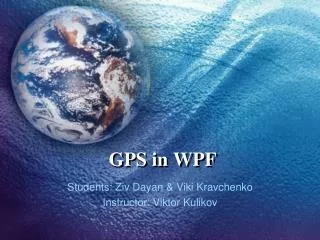
GPS Path Tracking Application in WPF: A Student Project
This WPF application enables users to record paths while walking, driving, or traveling anywhere using a GPS receiver. Users can mark their favorite locations such as cafes, parks, and schools, and display them on a map with customizable colors. The project utilizes the NMEA 0183 specification for GPS data, integrates with Google Static Maps API for map visuals, and allows data storage in binary or XML formats. This highly customizable solution is developed with a clear separation of appearance and behavior using XAML and C#.

GPS Path Tracking Application in WPF: A Student Project
E N D
Presentation Transcript
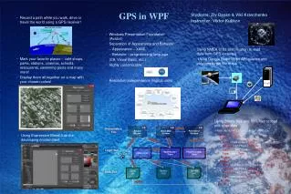
GPS in WPF • Students: Ziv Dayan & VikiKravchenko • Instructor: Viktor Kulikov Path Select Window Show Map Window Record Window getPath Presentation Tier • Record a path while you walk, drive or travel the world using a GPS receiver! • Mark your favorite places – café shops, parks, stations, cinemas, schools, restaurants, swimming pools and many more! • Display them all together on a map with your chosen colors! writeMarker createPolyline getData record path clsValidator Validate MakeHandler Class PolylineCreator Class Logic Tier • Windows Presentation Foundation (Avalon) • Separation of Appearance and Behavior • Appearance – XAML • Behavior – programming language (C#, Visual Basic, etc.) • Highly customizable • Resolution independence (logical units) Read from GPS Validate read/write save path binary .pth Markers XSD Markers XML • Using NMEA 0183 specification to read data from GPS receivers • Using Google Static Maps API queries and polylines to get the maps Data Tier read file • Using Binary files and XML files to load and store data <?xml version=”1.0” encoding=”utf-8” ?> <Markers> <Marker> <Name>Café Greg</Name> <Latitude>32.7763</Latitude> <Longitude>35.0249</Longitude> <Type>cafe</Type> </Marker> <Marker> <Name>Fishbach Computer Farm</Name> <Latitude>32.777</Latitude> <Longitude>35.0245</Longitude> <Type>computer</Type> </Marker> </Markers> • Using Expression Blend 3 as the developing environment