StreamStats:
StreamStats:. A Web Site for Stream Information. By Kernell Ries. Outline. Background Massachusetts StreamStats National StreamStats Prototype Presentations by StreamStats Team Implementation Plans and Unresolved Issues. Background. Need for Streamflow Statistics.

StreamStats:
E N D
Presentation Transcript
StreamStats: A Web Site for Stream Information By Kernell Ries
Outline • Background • Massachusetts StreamStats • National StreamStats Prototype • Presentations by StreamStats Team • Implementation Plans and Unresolved Issues
Need for Streamflow Statistics • Water resources planning, management, and permitting by Federal, State, local agencies • Instream flow determinations for controlling pollution and protecting habitat • Designing and permitting facilities such as wastewater-treatment plants, hydropower plants, and water-supply reservoirs • Designing structures such as roads, bridges, culverts, dams, locks, and levees
Problems in Providing Statistics • Published streamflow statistics for data-collection stations are scattered among hundreds of reports nationally • Many publications are out of date and/or out of print • Labor cost for information requests is high • Streamflow statistics are not available everywhere they are needed
Regression Equations • Used to estimate streamflow statistics for ungaged sites • Relate streamflow statistics to measured basin characteristics • Developed by all 48 USGS Districts on a State-by-State basis through the cooperative program • Often not used because of large efforts needed to determine basin characteristics • Users often measure basin characteristics inaccurately, increasing errors in estimates
Example Regression Equation • Regression equations take the form:Q100 = 0.471A0.715E0.827SH0.472 • where: A is drainage area, in square miles E is mean basin elevation, in feet SH is a shape factor, dimensionless
Massachusetts StreamStats provides- • Published streamflow statistics, basin characteristics, and other information for data-collection stations • Estimates of streamflow statistics, basin characteristics, and other information for user-selected points on ungaged streams
Massachusetts StreamStatshttp://ststdmamrl.er.usgs.gov/streamstats/
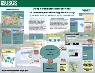
Web Application Components User Interface Streamflow Statistics Database Statistics Calculation Program GIS Database
User Interface • Displays ~ 120 map layers • Allows adding/subtracting layers one at a time • Zoom, pan, identify • Displays data-collection site locations • Allows selection of data-collection site locations and ungaged sites • Displays results in a Web browser window
Statistics Database Includes • Descriptive information, such as station name and number, coordinates, period of record • Previously published streamflow statistics for data-collection stations • Previously published basin characteristics, such as drainage area, total stream length, mean basin slope
GIS Database Includes • Map layers needed to determine drainage boundaries and areas • Map layers needed to measure basin characteristics in regression equations • Map layers needed to locate sites of interest, such as state and town boundaries, streams, and roads • Digital topographic maps (DRG’s) for detailed selection
Statistics Calculation Program • Determines drainage boundaries and measures basin characteristics for user-selected sites • Solves regression equations to obtain estimated streamflow statistics and provides prediction intervals as estimates of errors • Delivers basin characteristics, streamflow statistics, prediction intervals, and maps of user-defined basins to user interface
Benefits • Published statistics are readily available • Ungaged site process takes 5 to 15 minutes • Large collections of maps, equipment, and software are not necessary • Consistent information delivery • Little or no additional error is introduced • Only basic understanding of hydrology, computer science, geographic analysis is needed • Reduced information requests
National Prototype • Prototype will potentially work for any State • Easier to use and with more functionality than the MA application • Currently implemented only for parts of ID • Implementation planned for NH, VT, MA, ID, TN, and KS within a year • In cooperation with ESRI
Functionality • Zoom to street address, geographic name, or coordinates • Display of default base data layers for selected map scale ranges • Evaluate basin boundaries in the map frame • Print maps shown in the map frame • Download basin boundary and other map data • More analysis functionality (drainage-area ratio estimates, weighted estimates, etc.) is planned
Development Strategy • Program will run as a dll in ESRI software (ArcMap, ArcIMS, ArcSDE) • Programming done in MS Visual Basic and XML, based on the ArcGIS Hydro-Data Model and Tools • All GIS data will reside on a single server • New streamflow statistics database was developed • The National Flood Frequency Program (NFF) used to solve regression equations • Extensive pre-processing of basin characteristics to speed computations
StreamStatsDB • StreamStatsDB is used to manage streamflow and basin characteristics for data-collection stations
StreamStatsDB, cont’d • Linked to map in user interface showing site locations • Built using MS Access and Visual Basic • Contains fields for all streamflow and basin characteristics that are currently used, and allows new characteristics to be added • Data entered by District office personnel
National Flood Frequency Program • NFF will solve regression equations for StreamStats
Modifications to NFF • Ability to solve regression equations for any flow type • Calculation of prediction intervals • Calculation of drainage-area ratio estimates and weighting with regression estimates • Adding of data base attributes to allow use as a subroutine of StreamStats • Urban equations will not be available in StreamStats
Dean Djokic, Zichuan Ye (ESRI) • Prototype demonstration • Conceptual design • Integration with ArcHydro Tools
Jacqueline Coles (USGS) • Prototype system configuration • Web deployment
Alan Rea (USGS) • Data requirements and architecture • EDNA approach
Peter Steeves (USGS) • New England approach
Kernell Ries (USGS) • Implementation plans • Unresolved Issues • Summary
Implementation Plan • District offices will complete required work, usually through cooperative funding • StreamStats team will provide guidance and support to Districts • States will be put on line internally to check results • States will be made available to the public when results have been proven acceptable
District Responsibilities • Provide regression equations • Populate the streamflow statistics database • Develop any necessary GIS data • Test the application and summarize results • Potentially develop new regression equations, using GIS data to measure basin characteristics • Approve use of equations on Web
State Implementation Options • Implement regression equations first • Implement existing equations only • Develop new equations • Implement database for data-collection sites first • Populate with previously calculated statistics • Calculate new statistics • Implement database and regression equations at the same time
Long-Term Plan • Include additional States • Add drainage-area ratio estimates • Add batch processing • Add automated update of non-interpretive streamflow statistics • Add methods for regulated streams • Add sediment (and possibly other) data
Internal Issues • Integration with other USGS efforts, such as the National Map, NWIS-Web, SPARROW, TerraServer • Standardized measuring procedures and naming of basin characteristics • Policy for updating streamflow statistics for data-collection stations • Long-term support
External Issues • Links to other applications and data bases, such as EPA’s EnviroMapper, FEMA’s MSC Product Map Search, NRCS’s Lighthouse Project • Software updates (Arc 9, etc.) • Technical support of ArcHydro Tools
Summary • StreamStats uses cutting-edge technology to put stream information in the hands of users • Design is based on the ArcHydro Data Model and the functionality of the ArcHydro Toolset • Design is flexible and expandable • Implementation for States will be done through cooperative funding agreements • Full implementation will likely take several years
More information • National StreamStats web page • http://water.usgs.gov/osw/programs/streamstats.html • Massachusetts StreamStats web page • http://ststdmamrl.er.usgs.gov/streamstats/ • NFF Program web page • http://water.usgs.gov/software/nff.html