Download
1 / 12
120 likes | 264 Views
GIS in Natural Resource Education: Where are We Headed?. 9th Biennial Conference University Education in Natural Resources Warner College of Natural Resources — Colorado State University — March 22-24, 2012.

E N D
GIS in Natural Resource Education: Where are We Headed? 9th Biennial Conference University Education in Natural Resources Warner College of Natural Resources — Colorado State University — March 22-24, 2012 This presentation describes the idea of SpatialSTEMfor teaching map analysis and modeling fundamentals within a mathematical/statistical context that resonates with science, technology, engineering and math/stat communities The premise is that “maps are numbers first, pictures later”and we do mathematical things to mapped data for insight and better understanding of spatial patterns and relationships within decision-making contexts …moving from Where is What graphical inventories to Why, So What and What If within a problem-solving environment requires Spatial Reasoning skills of both GIS specialists and domain experts Presentation byJoseph K. Berry W.M. Keck Scholar in Geosciences, University of Denver Adjunct Faculty in Natural Resources, Colorado State UniversityPrincipal, Berry & Associates // Spatial Information Systems Email: jberry@innovativegis.com— Website: www.innovativegis.com/basis
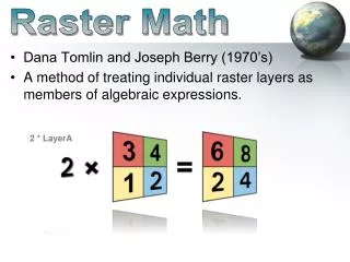
Making a case for SpatialSTEM The lion’s share of the growth has been GIS’s ever expanding capabilities as a “technical tool” for corralling vast amounts of spatial data and providing near instantaneous access to remote sensing images, GPS navigation, interactive maps, asset management records, geo-queries and awesome displays. In just forty years GIS has morphed from boxes of cards passed through a window to a megabuck mainframe that generated page-printer maps, to today’s sizzle of a 3D fly-through rendering of terrain anywhere in the world with back-dropped imagery and semi-transparent map layers draped on top— all pushed from the cloud to a GPS enabled tablet or smart phone. What a ride! Turning GIS Education on Its Head …engage “domain expertise” in GIS– outreach to other disciplines However, GIS as an “analytical tool” hasn’t experienced the same meteoric rise— in fact it might be argued that the analytic side of GIS has somewhat stalled over the last decade. This presentation describes a SpatialSTEMapproach for teaching map analysis and modeling fundamentals within a mathematical/ statistical contextthat resonates with science, technology, engineering and math/stat communities. The premise is that“maps are numbers first, pictures later” and we do mathematical things to mapped datafor insight and better understanding of spatial patterns and relationships within decision-making contexts. …from “Where is What”graphical inventories to a “Why, So What and What If” problem solving environment— “thinking with maps” SpatialSTEM Duane Marble December 1997 Spatial Reasoning (Berry)
The “-ists” and the “-ologists” Together the “-ists” and the “-ologists” frame and develop the Solution for an application. The“-ists” The“-ologists” — and — …understand the “tools” that can be used to display, query and analyze spatial data Data and Information focus …understand the “science” behind spatial relationships that can be used for decision-making Knowledge and Wisdom focus Application Space Geotechnology’s Core “-ists” “-ologists” Solution Space Technology Experts Domain Experts (Berry)
The “-ists” and the “-ologists” (a larger tent) Decision Makers utilize the Solution …under Stakeholder, Policy & Public auspices “Policy Makers” “Stakeholders” “Decision Makers” Application Space Geotechnology’s Core “-ists” “-ologists” Solution Space Technology Experts Domain Experts GIS Expertise Spatial Reasoning But current GIS offerings are designed for GIS Specialists… …forcing non-GIS students to become GIS’perts (Berry)
The Enlarging GIS Community (historical evolution) Systems Applications General Programmers GIS Developers System Managers Data Providers GIS Specialists General Users Public Users 1970s – a few hundred innovators establishing the foundation of geotechnology …a deep keel of knowledge in Science and Technology 1980s – several thousand pacesetters applying the technology to a small set of disciplines (RS, GIS) 1990s – hundreds of thousands GIS specialists and general users (RS, GIS, GPS) 2000s – millions of general and public users (RS, GIS, GPS, GeoWeb) …minimal S&T knowledge 2010s – billions of general and public users (RS, GIS, GPS, GW, Devices) (Berry)
Spatial Analysis Operations(Geographic Context) GIS as “Technological Tool” (Where is What) vs. “Analytical Tool” (Why, So What and What if) GIS Perspective: Spatial Analysis Reclassify(Position, Value, Size, Shape, Contiguity) Overlay(Location-specific, Region-wide) Distance(Distance, Proximity, Movement, Optimal Path, Visual Exposure) Neighbors(Characterizing Surface Configuration, Summarizing Values) Grid Map Layers Mathematical Perspective: Basic GridMath & Map Algebra ( + - * / ) Advanced GridMath (Math, Trig, Logical Functions) Map Calculus (Spatial Derivative, Spatial Integral) Map Geometry (Euclidian Proximity, Narrowness, Effective Proximity) Plane Geometry Connectivity (Optimal Path, Optimal Path Density) Solid Geometry Connectivity (Viewshed, Visual Exposure) Unique Map Analytics (Contiguity, Size/Shape/Integrity, Masking, Profile) Map Analysis Toolbox
Spatial Analysis Operations(Examples) Advanced Grid Math —Math, Trig, Logical Functions MapSurface Spatial Derivative 2500 Map Calculus —Spatial Derivative, Spatial Integral …is equivalent to the slope of the tangent plane at a location 500 y = e x The derivative is the instantaneous “rate of change” of a function and is equivalent to the slope of the tangent line at a point Surface Fitted Plane Curve SLOPE MapSurfaceFitted FOR MapSurface_slope Slope draped over MapSurface Spatial Integral 65% …summarizes the values on a surface for specified map areas (Total= volume under the surface) 0% Advanced Grid Math COMPOSITE Districts WITH MapSurface Average FOR MapSurface_Davg Surface Area …increases with increasing inclination as a Trig function of the cosine of the slope angle MapSurface_Davg SArea= Fn(Slope) Surface y = fn(x) The integral calculates the area under the curve for any section of a function. Curve (Berry)
Spatial Statistics Operations(Numeric Context) GIS as “Technological Tool” (Where is What) vs. “Analytical Tool” (Why, So What and What if) Spatial Statistics GIS Perspective: Grid Map Layers Surface Modeling (Density Analysis, Spatial Interpolation, Map Generalization) Spatial Data Mining (Descriptive, Predictive, Prescriptive) Statistical Perspective: Basic Descriptive Statistics (Min, Max, Median, Mean, StDev, etc.) Basic Classification(Reclassify, Binary/Ranking/Rating Suitability) Map Comparison (Joint Coincidence, Statistical Tests) Unique Map Descriptive Statistics (Roving Window Summaries) Surface Modeling (Density Analysis, Spatial Interpolation) Advanced Classification (Map Similarity, Maximum Likelihood, Clustering) Predictive Statistics (Map Correlation/Regression, Data Mining Engines) Map Analysis Toolbox (Berry)
Linking Data Space with Geographic Space Geographic Distribution Roving Window (weighted average) Geo-registered Point Data Spatial Statistics Continuous Map Surface Discrete Point Map Non-Spatial Statistics Surface Modeling techniques are used to derive a continuous map surface from discrete point data– fits a Surface to the data. Standard Normal Curve Average = 22.6 In Geographic Space, the typical value forms a horizontal plane implying the average is everywhere to form a horizontal plane …lots of NE locations exceed Mean + 1Stdev StDev = 26.2 X + 1StDev = 41.6 Histogram StDev= 18.7 X= 22.9 In Data Space, a standard normal curve can be fitted to the histogram of the map surface data to Identify the “typical value” (average) 80 0 30 40 50 60 70 10 20 Numeric Distribution +StDev Average (Berry)
Spatial Analysis Operations(Examples) Map Clustering: Elevation vs. Slope Scatterplot Cluster 2 Cluster 1 Cluster 2 Cluster 3 Elevation (Feet) Elevation (Feet) Slope draped on Elevation Two Clusters Slope (Percent) Slope (Percent) Cluster 1 Three Clusters X axis = Elevation (SNV Normalized) Y axis = Slope (SNV Normalized) Geographic Space Data Space Map Correlation: Spatially Aggregated Correlation Roving Window Scalar Value– one value represents the overall non-spatial relationship between the two map surfaces …1 large data table with 25rows x 25 columns = 625 map values for map wide summary Entire Map r = …where x = Elevation value and y = Slope value and n = number of value pairs …625 small data tables within 5 cell reach = 81map values for localized summary Localized Correlation Map Variable– continuous quantitative surface represents the localized spatial relationship between the two map surfaces (Berry)
The Softer Side of GIS (the NR experience) Spatial Reasoning, Dialog and Consensus Building Future Directions: • Social Acceptability as 3rd filter But Social Acceptability has become the critical third filter needed for successful decision-making. Historically Ecosystem Sustainability and Economic Viability have dominated Natural Resources discussion, policy and management. Public Involvement Banquet Table Podium Inter-disciplinary Science Team Table 1970s 2010s Increasing Social Science & Public Involvement (Berry)
So What’s the Point? • Current GIS education for the most part insists that non-GIS students interested in understanding map analysis and modeling must be tracked into general GIS courses that are designed for GIS specialists, • and that the material presented primarily focus on commercial GIS software mechanics • that GIS-specialists need to know to function in the workplace. 2) However, solutions to complex spatial problems need to engage “domain expertise” in GIS– outreach to other disciplines to establish spatial reasoning skills needed for effective solutions that integrate a multitude of disciplinary and general public perspectives. 3) Grid-based map analysis and modeling involving Spatial Analysis and Spatial Statistics is, in large part, simply extensions of traditional mathematics and statistics. 4) The recognition by the GIS community that quantitative analysis of maps is a reality and the recognition by the STEM community that spatial relationships exist and are quantifiable should be the glue that binds the two perspectives. Online Presentation Materials and References www.innovativegis.com/basis/Papers/Other/NReducation2012 Handout, PowerPoint and Online References …also see www.innovativegis.com/basis, online book Beyond Mapping III Joseph K. Berry — www.innovativegis.com (Berry)