Download
1 / 1
20 likes | 203 Views
Digitization and Georeferencing of Historical Images. B. Shambamuto 1 , J.C. Dixon 2 , J. Cothren 2 , J.B. Dixon 2 , C. Calhoun 2. 1 Wiley College, Marshall, TX. 2 University of Arkansas, Fayetteville, AR USA. IMPACT OF DATABASE ON ACADEMIC COMMUNITY.

E N D
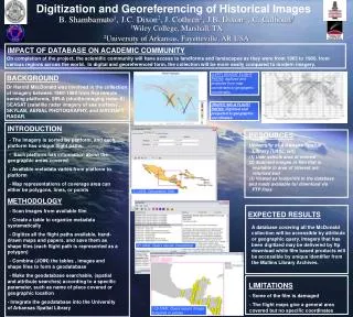
Digitization and Georeferencing of Historical Images B. Shambamuto1,J.C. Dixon2, J. Cothren2,J.B. Dixon2, C. Calhoun2 1Wiley College, Marshall, TX 2University of Arkansas, Fayetteville, AR USA IMPACT OF DATABASE ON ACADEMIC COMMUNITY On completion of the project, the scientific community will have access to landforms and landscapes as they were from 1965 to 1980, from various regions across the world. In digital and georeferenced form, the collection will be more easily compared to modern imagery. (LEFT) SEASAT FLIGHT PATHS: digitized and projected from map coordinates to geographic coordinates BACKGROUND Dr Harold MacDonald was involved in the collection of imagery between 1960-1980 from five remote sensing platforms, SIR-A (shuttle-imaging radar-A), SEASAT (satellite radar imagery of sea surface), SKYLAB, AERIAL PHOTOGRAPHY, and AIRCRAFT RADAR. (RIGHT) SIR-A FLIGHT PATHS: digitized and projected to geographic coordinates. INTRODUCTION RESOURCES • - The imagery is sorted by platform, and each platform has unique flight paths. • - Each platform has information about the geographic areas covered. • - Available metadata varies from platform to platform • - Map representations of coverage area can either be polygons, lines, or points • METHODOLOGY • - Scan images from available film • - Create a table to organize metadata systematically • - Digitize all the flight paths available, hand-drawn maps and papers, and save them as shape files (each flight path is represented as a polygon) • - Combine (JOIN) the tables , images and shape files to form a geodatabase • - Make the geodatabase searchable, (spatial and attribute searches) according to a specific parameter, such as name of place covered or geographic location • - Integrate the geodatabase into the University of Arkansas Spatial Library University of Arkansas Spatial Library (UASL, left) (1) User selects area of interest (2) Scanned images or film that is available in area of interest are returned and (3) Viewed as footprints in the database and made available for download via FTP links (1) UASL Geographic filter EXPECTED RESULTS A database covering all the McDonald collection will be accessible by attribute or geographic query. Imagery that has been digitized may be delivered by ftp download while film based products will be accessible by unique identifier from the Mullins Library Archives. (2) UASL Query results (metadata) LIMITATIONS - Some of the film is damaged - The flight maps give a general area covered but no specific coordinates ( (3) USAL Query results (Image footprints in yellow)