Download
1 / 90
1.02k likes | 1.92k Views
Explore Earth's tilt, seasons, axis, rotation, revolution, and climate patterns. Learn how the tilt affects day length and global wind patterns. Discover climate zones and factors influencing climate. Understand the Coriolis effect and meteorology basics.

E N D
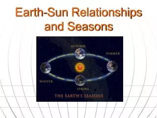
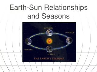
Earth’s Tilt and Seasons
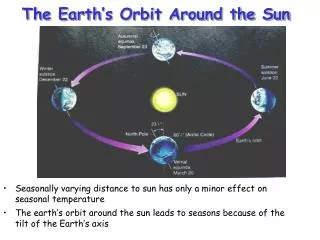
Axis: • imaginary line that passes through Earth’s center and the North & South Poles • Earth’s axis tilt = 23.5° • causes Earth’s seasons • causes ‘length’ of day to change throughout the year
23.5° 23.5° Plane of orbit
Rotation: • Earth’s spinning onits axis • causes night & day • Earth rotates every 24 hours
Revolution: • movement of one object around another • Earth revolves around the sun every 365.25 days
Orbit: • an object’s path as it revolves around another object • Earth’s orbit around the sun is slightlyelliptical, not perfectly circular
When we are tilted toward the sun, we have summer. • When we are tilted away from the sun, we have winter
23.5° 23.5° Plane of orbit
Equator: imaginary line encircling the Earth like a belt at 0° latitude • All lines of latitude are measured as north or south of the equator. Label your map!
Tropic of Cancer: latitude 23.5° N Tropic of Capricorn: latitude 23.5°S Label your map!
Arctic Circle: latitude 66.5° N Antarctic Circle: latitude 66.5°S Label your map!
Solstice: 2 days of the year when the noon sun is directly overhead at either 23.5° S or 23.5° N • Summer: longest “day” of year (daylight) • Around June 21st • Winter: shortest “day” of year (daylight) • Around Dec. 21st
Equinox: 2 days of the year when the noon sun is directly overhead at the equator (equal amt. of day & night) • Vernal (spring) • Around March 21st • Autumnal (fall) • Around Sept. 21st
Copy this diagram into your notes. Seasons simulator
Climate & Global Wind Patterns
Weather: current condition of Earth’s atmosphere at a particular time & specific place
Climate: average weather over a long period of time (decades/centuries)
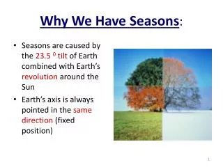
Because sun’s rays strike earth at different angles, we have unequal heating of the earth’s surface
Two factors that influence climate • Temperature • Precipitation
4 Factors influencing a climate’stemperatures • Latitude • Altitude • Distance from water • 4. Ocean currents
Latitude: • distance on a map measured north & south of the equator in degrees Polar Label your map! GAH! The spelling on this illustration is terrible. Stupid internet! Polar
3 BASIC CLIMATE ZONES • A. Tropical zone = HOT • near equator • b/t Tropic of Cancer (23.5°N) • and • Tropic of Capricorn (23.5°S)
Tropic of Cancer (23.5N) Tropic of Capricorn (23.5S) Label your map!
B. Temperate zones (2 ) have seasons, not always hot or cold b/t Tropic of Cancer (23.5°N) and Arctic Circle (66.5°N) and b/t Tropic of Capricorn (23.5°S) and Antarctic Circle (66.5°S)
Arctic Circle (66.5N) Tropic of Cancer (23.5N) Tropic of Capricorn (23.5S) Antarctic Circle (66.5S) Label your map!
C. Polar zones (2) = COLD b/t Arctic Circle (66.5°N) and North Pole (90°N) and b/t Antarctic Circle (66.5°S) and South Pole (90°S)
Arctic circle (66.5N) Antarctic circle (66.5S) Label your map!
2. altitude: distance above earth’s surface; measured from sea level higher altitudes = cooler temps. Mt. Kilimanjaro latitude = 3°S
3. distance from LARGE bodies of H2O (oceans or inland seas) closer to H2O = more moderate climate
4. ocean currents: • flow of water in a particular direction in the ocean • warm currents carry warm H2O; • cold currents carry cold H2O
Gulf Stream: warm H2O ocean current starts at tip of Floridaand warms eastern U.S. & western Europe
desert H2O Copy this diagram to show windward (wet) & leeward (dry) sides of mountain
2. prevailing winds: winds that blow in one general direction Aerosols in the atmosphere (video)
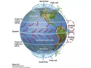
a. Trade winds • flow toward equator from about 30°N & 30°S latitude • blow from the east to the west • can bring storms like hurricanes across the ocean from Africa to the U.S. • used by trading ships to quickly get across the ocean from Europe to the New World
Label your map! 60°N 30°N 0° 30°S 60°S
b. Westerlies • blow between 30 ° and 60 ° latitude in both the N and S hemispheres • move from west to east • move weather across the U.S. and Canada
http://www.ssec.wisc.edu/data/us_comp/movie-large.php 60°N 30°N 0° 30°S 60°S
c. Polar Easterlies • Dry and extremely cold air from the poles • Flow between the poles and the Westerlies, in both N and S hemispheres. • Blow from east to west
Label your map! 60°N 30°N 0° 30°S 60°S
60°N 30°N 0° 30°S 60°S
The Coriolis Effect • caused by earth's rotation, currents seem to: • turn clockwise in theNorthern Hemisphere • turn counterclockwisein the Southern Hemisphere. • influences the direction of winds & ocean currents around the world
Meteorology Weather you like it or not! (4m) National Geographic.com Weather 101