Download
1 / 28
280 likes | 424 Views
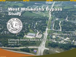
West Waukesha Bypass Study. Community Sensitive Solutions Advisory Group Meeting No. 5 January 31, 2011. Meeting Purpose. Update advisory group on the current status of the project Review the alternatives under consideration and their impacts Obtain your input on the alternatives

E N D
West Waukesha Bypass Study Community Sensitive Solutions Advisory Group Meeting No. 5 January 31, 2011
Meeting Purpose • Update advisory group on the current status of the project • Review the alternatives under consideration and their impacts • Obtain your input on the alternatives • Discuss upcoming activities
Remaining Alternatives -- North Section --No-Build Alternative --4-Lane Alternative
Remaining Alternatives -- Central Section -- No-Build Alternative --Three 2-Lane Alternatives -- One 4-Lane Alternative
2-Lane and 4-Lane Alternatives • South of Summit Avenue the study team is evaluating 2-lane and 4-lane options; all would include an off-road bike path • Three different two-lane alternatives under consideration • Incremental improvements (reconstruct the roadway, addressing existing problems except intersections; will incur right-of-way and relocation impacts) • Full reconstruction, on existing County TT alignment (completely reconstruct existing roadway including intersections; will incur right-of-way and relocation impacts) • Full reconstruction, off of existing County TT (follow mapped bypass route, reduces driveways that connect to County TT, reduces impacts to some residences; existing County TT would remain as a frontage road in spots) • The key issue is whether an improved 2-lane roadway can adequately handle anticipated future traffic volumes (year 2035)
Remaining Alternatives -- South Section --No-Build Alternative -- Three 2-Lane Alternatives -- One 4-Lane Alternative
Features of Alternatives South of Sunset Drive • Merrill Hills Road (Golf Course East Alternative) • Includes improvements to Hwy 59 between Merrill Hills Road and County X • Avoids environmental impacts in Pebble Creek corridor • Avoids Sunset /County X intersection; more direct route to Hwy 59 than Sunset-to-County X alternative • 10-11 residential relocations; dramatic increase in traffic adjacent to remaining 15 +/- residences • Hills near Sunset Drive require large “cut” and bridge over Sunset Drive • Higher cost than Pebble Creek corridor alternative
Features of Alternatives South of Sunset Drive (cont.’d) • Pebble Creek Corridor • This is the alignment included in city, county and regional plans since the 1970’s • Most direct route to Hwy 59 • No crossing of Pebble Creek is required • Lower cost than Golf Course East, about the same as Sunset-to-X • Highest impact to primary environmental corridor • 0 to 2 residential impacts • Close to some residences on Hawthorne Hollow Drive • Potential impacts to state threatened and endangered species (Butler’s garter snake, Blandings turtle, long-eared sunfish) • Wetland impacts vary from 3 to 15 acres of wetland
Features of Alternatives South of Sunset Drive (cont.’d) • Sunset-to-County X Alternative • Follows existing county trunk highways • Takes advantage of recent widening of County X • Indirect connection to Hwy 59 • 5-8 residential relocations on Sunset Drive • Adds more traffic to Sunset Drive/County X intersection • About the same cost as Pebble Creek corridor alternative; lower cost than Golf Course East • Wetland impact 7 acres, and two bridges over Pebble Creek • Possible state threatened or endangered species impacts (Butler’s garter snake, Blandings turtle, long-eared sunfish)
Traffic Impacts • New traffic info from SEWRPC • Study team asked SEWRPC to project future traffic volumes if 4 lanes from I-94 to Summit Ave and 2 lanes from Summit to Hwy 59 • Key finding is that 14,000 to 19,000 vehicles per day would use County TT south of Summit Avenue in year 2035; County and WisDOT use 15-17,000 vehicles per day as threshold for considering four lanes • Using SEWRPC projections, study team assessed how traffic would operate during peak hours on a two-lane roadway and a four-lane roadway • Two-lane level of service “D” or “E”; four-lane level of service “B” and “C” • At intersections: • signalized intersections at Madison and Sunset would operate OK with a 2-lane or 4-lane alternative • unsignalized intersections would “fail” on a 2-lane undivided alternative (unless a median is added at unsignalized intersection like Kame Terrace, MacArthur) • unsignalized intersections would operate better on a 4-lane alternative
Traffic Impacts 14,000 15,000 Golf Course East
Traffic Impacts 14,000 16,000 14,000 15,000 Golf Course East PebbleCreek
Traffic Impacts 14,000 14,000 16,000 19,000 Sunset-to-X 14,000 15,000 Golf Course East PebbleCreek
Intersection Level of Service Definition • LOS A is the highest level of service that can be achieved. Intersection approaches are open, turns are easily made, and nearly all drivers find freedom of operation. Average delays are less than 10 seconds. • LOS B represents stable operation. At signalized intersections average delays are 10 to 20 seconds. At unsignalized (stop signs) intersections, average delays are 10 to 15 seconds. • LOS C still represents stable operation, but periodic backups of a few vehicles may develop. Most drivers begin to feel restricted. At signalized intersections, average delays are 20 to 35 seconds. At unsignalized intersections, average delays are 15 to 25 seconds. • LOS D represents increasing traffic restrictions. Delays may be substantial during short peaks but no excessive backups. At signalized intersections, average delays are 35 to 55 seconds. At unsignalized intersections, average delays are 25 to 35 seconds. • LOS E represents the highest operating capacity of the intersection. At signalized intersections, average delays are 55 to 80 seconds. At unsignalized intersections, average delays are 35 to 50 seconds. • LOS F represents jammed conditions, the intersection is over capacity and safe gaps in the traffic flow are minimal. At signalized intersections, average delays exceed 80 seconds. At unsignalized intersections, average delays exceed 50 seconds.
Madison St. is currently unsignalized
Residential Relocations • North of Summit Avenue: no relocations and minimal right-of-way acquisition • Summit Avenue to Sunset Drive: • Off-alignment • 2-lane/4-lane: 2 relocations • On-alignment • 2-lane: 6-8 relocations • no 4-lane on-alignment option • South of Sunset Drive • Golf Course East • 2-lane: 9 relocations • 4-lane: 11-12 relocations • Pebble Creek: 0-2 relocations; no difference between 2- and 4-lane • Sunset Drive • 2-lane: 1-3 relocation • 4-lane : 6-8 relocations
Cost Estimate • 4-Lane on mapped bypass route • Golf Course East: $56 million • Pebble Creek: $48 million (pending soil borings) • Sunset-to-X: $46 million • 2-Lane on mapped bypass route (4 lanes north of Summit Ave) • Golf Course East: $36 million • Pebble Creek: $32 million • Sunset-to-X: $29 million • Improved 2-Lane on existing County TT (4 lanes north of Summit Ave) • $33-34 million
What’s Next • Prepare draft Alternatives Section for public and government agency review (DNR, EPA, etc.) • Begin preparing other sections of the Draft Environmental Impact Statement (EIS) • Hold Public Informational Meeting #3 on February 10th (Waukesha West cafeteria), 4-8pm • Context Sensitive Solutions advisory group meeting #6 in spring • Draft EIS approved in Spring or Summer 2011 • Public Hearing shortly after Draft EIS approved • Final EIS in Fall 2011 • Complete study at end of 2011