Download
1 / 91
910 likes | 932 Views
Plate tectonics is a scientific revolution that explains volcanoes, earthquakes, sea floor spreading, mountain chains, and the occurrence of same fossils on different continents. This concept integrates evidence from multiple branches of science and was first suggested based on evidence from cartography, geology, and paleontology. Despite initial rejection, accumulating evidence such as the fossil record, Earth's crust and mantle, magnetism, and paleomagnetism eventually led to the acceptance of plate tectonics.

E N D
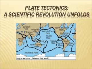
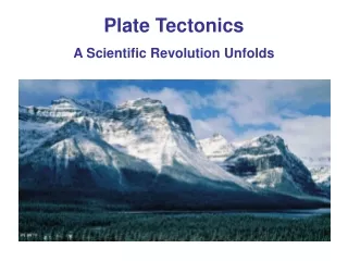
Plate Tectonics A Scientific Revolution Unfolds
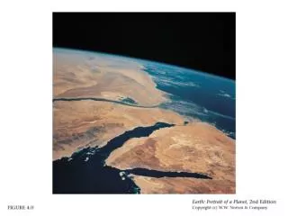
Why? Why is Mount Everest over 29000 feet high?
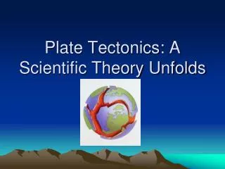
Plate Tectonics The unifying concept of the Earth sciences The outer portion of the Earth is made up of about 20 distinct “plates” (~ 100 km thick), which move relative to each other Plate tectonics explains: Volcanoes Earthquakes Sea floor spreading Mountain chains Occurrence of same fossils on different continents
Plate Tectonics Integrates evidence from many branches of science First suggested based on evidence from cartography, geology and paleontology Fully embraced after evidence from geophysical measurements However, the proof of plate tectonics was a long rambling road
Atlantic Coastline 300-400 years ago (after accurate maps became available) it was noticed that the coastline on both sides of the Atlantic could fit together like a jigsaw puzzle
Atlantic Coastline The fit was even better when you took the continental slope into consideration In 1858, Antonio Snider-Pellegrini, an American published a sketch showing this fit
Gondwanaland In the 1890s, the Austrian Geologist Eduard Suess suggested that the present day southern continents once been formed in a super continent which he called Gondwanaland The name comes from the Gondwana region in India
Gondwanaland Gondwanaland included Antarctica, South America, Africa, Madagascar, Australia-New Guinea, New Zealand and Indian (and today we include Arabia)
Gondwanaland Unfortunately, Suess did not have any evidence other than the jigsaw puzzle fit He could not explain how Gondwanaland split up into the modern continents However, he got to be on a stamp
Continental Drift Proposed by the prominent geologist Alfred Wegner in 1912 based on his observation of drifting sheets of ice The concept is that large-scale horizontal movements of the Earth’s continents are responsible for the major topographical features such as mountains and ocean basins Called his super-continent “Pangaea” Wegner spent the next two decades, until his death, promoting continental drift
Rejection of Continental Drift Talk about an idea whose time had not arrived! Most scientist ridiculed Alfred Wegener’s idea Not even the public believed it possible No proof that continents move No “driving mechanism” that could move the continents. “Why should the continents move?”
Accumulating Evidence Fossil record Earth’s crust and mantle Magnetism and the Earth’s magnetic field Paleomagnetism Magnetic reversals The topography of the seafloor Age of the seafloor Seafloor spreading Polar wandering
Fossil Record The fossil record had revealed that the geology and paleontology matched on opposite sides of the Atlantic Ocean
Fossil Record In fact, there are matching fossil records that span across all of the continents Without continental drift, this is hard to explain
Crust and Mantle The Earth’s crust and uppermost mantle are solid, somewhat brittle and elastic This outmost solid layer is called the lithosphere It is thinnest under the oceans, averaging 50 kilometers (km) thick The lithosphere under the continents can be up to 100 kilometers thick
Crust and Mantle The layer below the lithosphere is called the asthenosphere and it extends to a depth of 300 kilometers The rock is not rigid and can flow plastically due to the high temperature and moderate pressures The existence of the plastic asthenosphere made plate motion more feasible
Magnetism Most iron-bearing minerals are at least weakly magnetic Each magnetic mineral has a Curie temperature, the temperature below which it remains magnetic Above the Curie temperature the mineral is not magnetic The Curie temperature varies from mineral to mineral, but it is always below the melting temperature of the mineral
Earth’s Magnetic Field The Earth has a magnetic field This why a compass points to the north The simple presence of iron in the Earth’s core is not enough to account for the Earth’s magnetic field The high temperatures in the Earth’s core are far above the Curie temperature for any magnetic mineral
Earth’s Magnetic Field It is believed that the Earth’s magnetic field originates in a layer called the outer core The outer core is a metallic fluid consisting mainly of iron This metallic fluid is in motion and the convection currents act like a giant dynamo, converting mechanical energy into magnetic energy
Paleomagnetism A hot magma is not magnetic As a magma cools and solidifies, the iron-bearing minerals (such as ferromagnesian silicates) crystallize Eventually, the minerals cool below the Curie temperature and the iron-bearing minerals become magnetic
Paleomagnetism Like tiny compass needles, these magnetic minerals align themselves parallel to the lines of force of the Earth’s magnetic field This remnant magnetism, which is also called paleomagnetism, points to the north pole like a sign post But...
Magnetic Reversals About a century ago, a sequence of lava flows were found in France where some of the flows had the north and south poles reversed Therefore, the north pole and south pole must have repeatedly swapped positions
Magnetic Reversals These magnetic reversals have occurred though out the history of the Earth They occur on an irregular basis ranging in time from tens of thousands of years to millions of years
Magnetic Striping on Seafloor In the 1950s, the Atlantic seafloor was found to consist of alternating stripes of normal and reversely magnetized rocks
Topography of the Atlantic Also, in the 1950s, it was discovered that an underwater mountain range ran north-south in the middle of the Atlantic Ocean The Mid-Atlantic Ridge rises as high as 2 kilometers above the abyssal plain
Atlantic Ocean Sea Floor In the 1960s, samples were collected from the Atlantic seafloor using special ships with drill rigs The rocks of the Atlantic seafloor were discovered to be basalt Basalt contains radioactive isotopes (such as U235) which can be dated
Atlantic Ocean Sea Floor It was discovered that the youngest rocks of the Atlantic Ocean seafloor are found along the mid-oceanic ridge And that farther you move away from the ridge, the older the rocks become on either side of the ridge The oldest rocks are along the continental boundaries
Plates that Move In 1965 Wilson proposed the concept that the crust of the Earth is a mosaic of interacting plates – hence “plate tectonics” These plates move relative to each other The continents ride on these plates Geologic features, such as mountains, volcanoes and earthquakes occur along the plate boundaries
Plates Move Slowly Plates move at different speeds: Measured using GPS and magnetic data Slow spreading: 30 mm/yr Fast spreading:100 mm/yr Or about the thickness of a fingernail in one day
Plates Move Slowly Plate movement is best described as chaotic
Plates that Move The red dots show that most major earthquakes occur along plate boundaries
Plates that Move The black triangles show that most volcanoes occur along plate boundaries
3 Types of Plate Boundaries In 1965, the Canadian Geologist, J. Tuzo Wilson, proposes that tectonic plates interact in three different ways along their boundaries 1. Transform 2. Divergent 3. Convergent
Divergent Plate Boundaries Usually start within continents Can grow to become ocean basin
Divergent Plate Boundaries A. Rifting occurs where tensional forces thin the crust, magma ascends and volcanoes form B. The crust is pulled apart, forming a valley
Divergent Plate Boundaries C. A long, narrow lake or sea forms D. Eventually, an expansive ocean basin and ridge are created
Divergent Plate Boundaries Can see the spreading on the island of Iceland
Continental Rifts Two examples are the East African and Rio Grande Rift Valleys This can be the beginning of ocean formation (although it may not get that far) Rifting often begins at a triple junction
Continental Rifts Note that uprise and decompression of the underlying asthenosphere results in magma formation The crust responds by brittle fracture
Continental Rifts Early rift sediments are downfaulted into the developing rift (graben) Erosion takes place on the sides of the rift valley
East African Rift Zone Perhaps the most interesting and spectacular plate tectonic rift zone on the land surface Ol Doinyo Lengai Ruwenzori
East African Rift Zone The East African Rift has a north-south orientation with the African Plate moving to the west and the Somali Subplate moving to the east
East African Rift Zone A triple junction, where three plates are pulling away from one another: the Arabian Plate, and the two parts of the African Plate (the Nubian and the Somalian) splitting along the East African Rift Zone
Rio Grande Rift The Rio Grande Rift Valley extends north from Mexico, near El Paso, Texas through New Mexico into central Colorado The rift is now essentially quiet tectonically, but significant deformation and faulting with major offsets was responsible for the formation of the rift during the past 30 million years
Rio Grande Rift The geology has been described as a "taffy-like" thinning of the lower crust, with upper crust faulting in many places, to produce the rift valley
Rio Grande Rift “Two features of the region most clearly exemplify the Southwest's geologic-climatic-demographic circumstances. These features constitute two "natural geographic corridors" or focal areas concerning the relationship between people and the Southwests physical environment: Arizona's Mogollon Rim Corridor and New Mexico's Rio Grande Rift Corridor”
Is the Earth Expanding? NO! The Earth is maintaining a constant diameter New crust is created at mid-oceanic ridges The old crust sinks back into the Earth at subduction zones alongconvergent plate boundaries
Convergent Boundaries There are three types of convergent plate boundaries Oceanic–Oceanic Japanese Islands Oceanic–ContinentAndes Mountains Continent–ContinentHimalaya Mountains We will look at each type