Download
1 / 33
330 likes | 569 Views
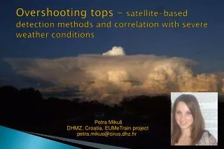
Overshooting tops – satellite-based detection methods and correlation with severe weather conditions. Petra Miku š DHMZ, Croatia, EUMeTrain project petra.mikus@cirus.dhz.hr. Outline. Introduction Methods of OT detection using satellite imagery Relationship between OT and severe weather

E N D
Overshooting tops – satellite-based detection methods and correlation with severe weather conditions Petra Mikuš DHMZ, Croatia, EUMeTrain project petra.mikus@cirus.dhz.hr
Outline • Introduction • Methods of OT detection using satellite imagery • Relationship between OT and severe weather • Data and methods • Examples • Conclusion and future work
Introduction: Overshooting top (OT) • a domelike protrusion above a cumulonimbus anvil • forms when a thunderstorm's updraft protrudes its equilibrium level • exists for less than 30 minutes and has a maximum diametar of ~ 15 km • penetrating convective storms affect on the transport of various chemical species (especially water vapor) from the troposphere into the stratosphere • generates gravity waves which can produce significant turbulence Figure: Diagram of a supercell thunderstorm, which shows the overshooting top rising above the anvil cloud
Examples: Overshooting tops Photo: Looking east from about 60 miles away, we see a line of towering cumulus clouds and a large supercell storm. Note the great amount of anvil overhang and the large overshooting dome at the summit of the updraft. This particular storm was producing a tornado that stuck downtown Ft. Worth, TX on March 28, 2000. Photo by Bluestein Photo: Supercell thunderstorm with overshooting cloud top and anvil overhang, looking southeast from about 40 miles away. This storm produced baseball hail, but no known tornadoes, along a track in southeast Oklahoma and southwest Arkansas
Introduction: Detection of OT using satellite imagery • visible channel imagery – OT as the lumpy textured appearance • can be observed only during the day
objective satellite – based detection of OT: • WV-IR BTD (Schmetz,1997; Setvak, 2010) • greater than zero degrees are related to convective cloud with high vertical extension • often identifies OT regions with a spatial extent that is significantly larger than that of commonly observed OTs • often produce a significant number of false OT detection • “IRW – texture” (Bedka, 2010) • combination of 11µm IR channel, a numerical weather prediction model tropopause temperature forecast, OT size and BT criteria (defined through analysis of 450 thunderstorm events) • IR brightness temperature minima < 215K • OT ≤ 15 km diameter
Figure : A) Contrast – enhanced Aqua MODIS 0.65 μm visible channel imagery, B) Color- enhanced Aqua MODIS IRW imagery, C) IRW – texture overshooting top detections, D) WV – IRW brightness temperature differences between 2 and 3 K (purple) and > 3 K (blue) (Bedka et al., 2010)
Introduction: Relationship between overshooting cloud top and severe weather • frequently produce hazardous weather (Bedka et. Al, 2010) • often associated with cloud to ground lightning (Machado et al., 2009) • often associated with significant turbulence (Lane et al., 2003) • Table : The number of events where overshooting tops were found to occur near to the location of tornado, severe wind and large hail events recorded within ESWD (SEVIRI European Domain) and SPCD (GEOS – 12 U.S. Domain) (Bedka, 2010).
Motivation • Deep convective storms with OTs often produce hazardous weather conditions, such as heavy rainfall, damaging winds, large hail, cloud-to-ground lightning and tornadoes • OTs also generate gravity waves which can produce significant turbulence • These events can cause considerable property damages, influence everyday activities and even endanger the human lives
Data and methods • The OTs are detected from MSG data using BTD methods • Compared locations and times of appearance of the OTs with data measured by the automatic stations • Compared OT detections according the “IRW-texture” with data from automatic stations • Parallax correction • apperent displacement of cloud location in satellite imagery • depends on the height of the cloud top (important especially for high Cb clouds), its geographic location and position of the satellite • Method: each automatic station is shifted by the computed values of parallax shift for certain cloud top height
Parallax correction • Parallax correction for automatic stations (cloud height is constant – based on soundings data) • MSG satellite position: 0° • Parallax correction tables for 80 different cloud heights for NEimage section for the 0° position (http://www.convectionwg.org/parallax.php)
Criteria WV-IR IR brightness temperature < 215K >4K O3-IR >13K CO2-IR >3.5K COMB (WV-IR & O3-IR) >4K & >13K Satellite-based overshooting top detection methods • Brightness temperature difference (BTD) methods: • IR=10.8 µm • WV = 6.2 µm • O3 = 9.7 µm • CO2 = 13.4 µm • some studies showed that this BTD methods are usefull for determining cloud top heights of convective clouds (Kwon et al.)
OT and their relationship with severe weather conditions Zagreb
Example: OT vs. severe weather Zagreb, 01.07.2009. OT -13:45 UTC (Bedka, 2010) Blue: temperature: 23.8°C(13 UTC) – 21.4°C(15 UTC) Green: relative humidity Orange: precipitation: 1.8 mm during 30min Red: maximum wind speed: 16.2m/s; 14:06 UTC
Example: 24.05.2009 – 18:45 UTC Karlovac Karlovac
Example: OT vs. Severe weather Karlovac, 24.05.2009. OT -18:45 UTC (Bedka, 2010) Red: temperature: 23.8°C(19 UTC) – 18.6°C(20 UTC) Green: relative humidity Orange: precipitation: 12.3 mm during 25 min Blue: maximum wind speed: 17.4m/s; 19:09 UTC 24.05.2009, 18:00 – 20:00 UTC: Temporal distribution of lightning discharge – maximum around 19:45 UTC
Reflectivity in dBZ Height in km
Vert. Int. Liquid in mm Rainfall Rate in mm/hr • It has been concluded that all investigated methods indicate deep convection (but not necessarily OTs) !
Future work • Comparison of OT detections by all 4 (5) methods and automatic station data will be made – 2009 and 2010 detections already available! • OT validation database with OT signatures found in the HRV channel