Drainage
Drainage. Introduction. Water is component of all landscape designs that cannot be ignored. Water issues include: Too much Not enough Water being at an undesirable point Water flowing across an undesirable point Frost heave Too much water can be handled by drainage.

Drainage
E N D
Presentation Transcript
Introduction • Water is component of all landscape designs that cannot be ignored. • Water issues include: • Too much • Not enough • Water being at an undesirable point • Water flowing across an undesirable point • Frost heave • Too much water can be handled by drainage. • Not enough water can be resolved by using irrigation. • Drainage can also be used to move water from unwanted areas. • Drainage structures can be used to reroute water. • Drainage can also be used to reduce the effects of frost heave.
Site Analysis • Before starting to survey a site for drainage purposes it is important to evaluate the site. • If the site adjoins a waterway, do not remove the vegetation adjacent to and along the stream bank. • This vegetation is an essential buffer zone that will help maintain the water quality and curb erosion problems. • Check your survey or plat for the location of nearby flood plains. • If the land is in a flood plane, it is reasonable to expect the area will be inundated with water at some point. • It is important that no structures, especially homes, are built within a designated flood plane.
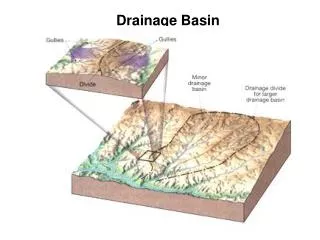
Site Analysis--cont. • Also check the map for drainage easements. • They should be labeled "d.e." on the plat and are usually located along property lines. • A drainage easement indicates that water will be probably flow along the easement after rainfall. • Erosion can be a problem along drainage easements. • Structures, fences, roads, etc. should not be constructed within drainage easements.
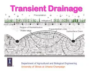
Drainage • Drainage is the natural or artificial removal of surface and sub-surface water from a given area. • Drains can be either surface or subsurface.
Need For Drainage • A landscape design that does not properly control runoff may cause damage to and devaluation of the property. • To prevent damage or devaluation of property, three questions must be answered. • What is the elevation of the design property in relation to adjacent properties. • Will water run onto the property, if so, were does it enter and were does it exit? • How will the landscape plan change the drainage at the site. • Drainage is needed to handle rooftop, driveway, and overland run off. • Four main issues to consider when caring for soil and grass roots are fertilization, drainage, aeration, and thatch control.
Eight Drainage Principles • Water flows downhill • Whenever it rains you have the potential for runoff. • The greater the intensity of the rain--the greater the potential for runoff. • Reducing the permeability of the soil increases runoff. • Increasing the non-permeabile area will increase runoff. • Water or silt on walkways during, or after a rain, is an indication of poor design. • A good landscape plan includes drainage in the plan. • Drainage plans rely upon slope, pipes, berms or other structures to control the direction the water flows.
Slope • Any area that is exposed to rainfall should always have some slope to direct the flow of water. • Water will puddle on flat, horizontal surfaces. • The amount of slope varies with the surface and the conditions of the site. • Turf areas = 2 - 3% • Paved areas = 2% • Foundations = special requirements One recommendation is a six inch drop within the first 10 feet.
Surface Drains • Surface drainage is controlling the flow of water using slope and shaped surfaces. • Shaped surfaces • Swales • Ditches • Berms • Surface drainage works best with small sites or for sites with a small amount of runoff.
Subsurface Drain • Subsurface drain is a system of collecting and disposing of rain water. • Common means of collection are a drain grate or perforated pipe.
Drain Outlet • Both surface and sub surface drains must have an outlet. • Modification of existing outlets is usually not very problematic, changing the location of an outlet may cause problems. • One alternative is to direct the water towards the street. • May require a permit. • Greater problem if the drain is a redirect and not the natural path. • Part of drainage plan that most municipalities require for development.
Drain Outlet--cont. • If codes do not allowed the redirection of water to the street, what are the options? • Unless you already have a landscape drainage system in place (allowing you to route the runoff into that system), you have two (2) options. 1. Channel the water to a location on the site (but make sure it’s not a neighbor's!) where it's less troublesome and where it can percolate into the ground.
Drain Outlet-cont. 2. Build a pond and direct the water into it. A pond may be constructed of stone or concrete A storm detention cell may be a code requirement. or natural.
Estimating Runoff Before a decision is made on the type and size of drainage structure or storage structure that is needed, the peak runoff rate and total volume of runoff must be determined. • The peak rate of runoff is required when sizing drainage channels and pipes. • The total amount of runoff is needed to size a pond.
Estimating Peak Runoff Rates • Several different methods are available. • Rational • Useful for estimating peak runoff rates from small areas. • Does not estimate volume of runoff. • USDA-NRS Technical Release 55 (TR-55) • Most popular method • Two methods • Tabular method • Graphical discharge method • US Army Corps of Engineers HEC-1 Model
Rational Method • The rational method is useful for estimating peak runoff rates from small <20 acre areas that are relatively uniform in topography and vegetation. • Peak runoff rates are important when sizing drainage structures, especially pipes. • Rational method uses a simple equation: The difficulty is getting accurate values for each variable.
Runoff Coefficient (C) • The runoff coefficient (C) is defined as the ratio of the peak runoff rate to the rainfall intensity. • The runoff coefficient mathematically indicates whether the runoff is likely to be high or low for the watershed. • The value of C depends on the type and characteristics of the watershed. • Values for “C” are usually determined from tables.
Rainfall Intensity (I) • The rainfall intensity used in the rational method is based on a specific rainfall duration and recurrence interval. • The recurrence used depends on the importance of the project. • Terraces and waterways are designed for a 10-year recurrence. • Spillways for dams may require a design based on a recurrence interval of 100 years or more. • The rainfall intensity can be determined from an intensity-duration-recurrence interval chart.
Rainfall Intensity, Duration & Recurrence Interval To find the correct value for rainfall intensity from the chart, the time of concentration must be known.
Time of Concentration (TOC) • The time of concentration for a watershed is defined as the time required for water to flow from the most remote point of the watershed to the outlet. • The peak rate will occur when the entire watershed contributes to the runoff. • The time of concentration is a function of drainageway length and slope. • Tables are available for TOC.
Area The area used is the number of acres in the watershed above the outlet. • Watershed area can be difficult to determine. • When a map is available a planimeter can be is used for this purpose. • Another method is placing a grid over the map and counting squares. • If the map is digital, mapping software can calculate area.
Rational Method Example Determine the peak runoff for a1- 1/2 acre lot that has grass planted on heavy soil with an average slope of 3%. The client says a 50 year reoccurrence interval is appropriate. The drainageway is 850 feet long and has a slope of 1.25 %. The first step is determining the C value. C = 0.18 to 0.22 Use 0.22
Example--cont. • The next step is to determine an appropriate value for the rainfall intensity. • The time of concentration is used to determine the intensity. A drainageway of 850 feet at 1.25% slope = 7 min • This example shows one of the problems of using tabular data. • What do you do when the data falls in between columns and/or rows? • In this case the lower number was used knowing that this will cause the calculated peak flow to be slightly higher.
Example--cont. With a TOC of 7 minutes and a 50 year interval, the IDR graph can be used to estimate rainfall intensity. I = 10 in/hr
Example--cont. Solving for peak runoff:
Mixed Watershed • The previous example assumed that the entire watershed had the same surface and slope. • This seldom happens, therefore the equation must be modified to accommodate mixed watersheds. • This is accomplished by calculating a “Weighted C”.
Mixed Watershed Example • Determine the peak runoff for a watershed that consists of .75 acres of impervious surface, 3.4 acres of lawn at 1.8 % slope and sandy soil and 2.2 acres of lawn at 0.75% slope and heavy soil. The drainageway is 400 feet long with a slope of 1.2%. • The first step is to determine the weighted C.
Mixed Watershed Example--cont. The next step is to determine the time of concentration and rainfall intensity. With a drainageway length of 400 feet and a slope of 1.2% the best number for TOC is 6 minutes.
Mixed Watershed Example--cont. • With a TOC of 6 minutes and a reoccurrence interval of 100 years, the rainfall intensity can be determined from the chart. • Rainfall intensity = 12 in/hour
Mixed Watershed Example--cont. • The peak runoff rate from the mixed watershed is: