Download
1 / 12
160 likes | 523 Views
WinGIS 2010. Geographic Information System & Microsoft Bing Maps. Key Features. WinGIS 2010. Desktop GIS Vector and raster data Integrated database Multiuser features Import, export (SHP, DXF, CSV, KML, …) GPS support ISO module Thematic maps Raster t ransformation

E N D
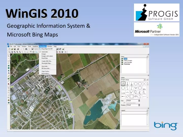
WinGIS 2010 Geographic Information System & Microsoft Bing Maps
Key Features WinGIS 2010 Desktop GIS Vectorandrasterdata Integrated database Multiuser features Import, export(SHP, DXF, CSV, KML, …) GPS support ISO module Thematicmaps Raster transformation Developer tools (SDK)
ISO Module / ThematicMaps WinGIS 2010
Microsoft Bing Maps as „embeddedmodule“in WinGIS WinGIS 2010 Bing Maps as „layer“ Online accesswithcaching road / terrainmaps Ortho / satelliteimages Hybrid maps Geocoder DB-Geocoder Use-orientedcosts (transactions) orflatrate Vectordatalocal / aerialimages in the „cloud“
Geocoder / Database Geocoder WinGIS 2010
Microsoft Bing Maps WinGIS 2010 New area-wideorthoimagesfor Europe and USA Online untilmid-year 2012 Quality (resolution): 20-30 cm / Pixel Vexcel „UltraCam“
Bing Maps Silverlight WebControl WinGIS 2010 Creatingmaps in WinGIS XML conversion Publishing on theweb (overlayofvectordataand Bing Maps) Database support
Bing Maps – Bird‘s Eye & Streetside View WinGIS 2010
Sensor / Telemetry Data Interface WinGIS 2010 Weather / soil / machinedata Real-time Localizationandvisualization in WinGIS DB support Publishing on the web
Developer Tools (SDK) WinGIS 2010 COM / ActiveX interface Simple accessandintegration Database connection Extensive functionlibrary Directaccesstomenuanduserinterface Integrated GIS control in theapplication(„Canvas“ mode)
Products & Projects WinGIS 2010 AGROffice/ DokuPlant (agriculturesoftware) LoGIStic (e.g. harvestlogistic) PipeGIS (pipelinemanagement) PROGIS MapServer (ORF – realityshow „Taxi Orange“) FOMUMIIS (Environment andriskmanagment) BAU-MATIC (buildingandcommunitymanagment) TREE-MATIC (forestapplikation) OIS – Objectinformationsystemforfirebrigades andothers
WinGIS 2010 PROGIS Software GmbH http://www.progis.com office@progis.com Bernhard Aigner GIS Software Development wingis@progis.com Online Shop http://shop.progis.com