Download
1 / 40
450 likes | 761 Views
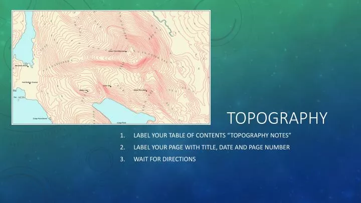
Topography. Label your table of contents “Topography Notes” Label your page with title, date and page number Wait for directions. Engage: Understanding Topography. Draw a box in your notes Close your hand in a fist. In pen, trace over the lines of your knuckle on one finger.

E N D
Topography Label your table of contents “Topography Notes” Label your page with title, date and page number Wait for directions
Engage: Understanding Topography Draw a box in your notes Close your hand in a fist. In pen, trace over the lines of your knuckle on one finger. Now open your hand and sketch what the lines look like in the box in your notes. Wait for directions
Topography Learning Objectives Identify structures on a topographic map. Use a topographic map to describe the elevation of landforms.
What is a topographic map? • A topographic map is a special kind of map that provides 3 dimensional information in a drawing. • Natural structures like mountains, valleys, plains, lakes, and rivers are shown on a topographic map. • You will also find manmade structures like roads, boundaries, radio towers, and major buildings • Topographic maps are used by engineers as they look for coal, oil, and gas. They can be used to plan residential and commercial . And they are used by the military and for recreational purposes like hiking and camping.
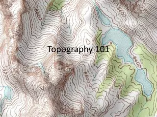
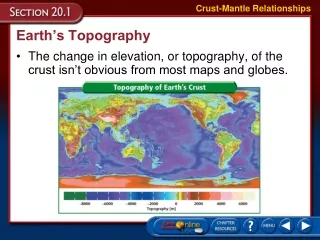
Topography Vocabulary • Topography is the shape, or features, of the land. • Contour Lines are lines that show an area’s elevation, slope, and relief.
Let’s keep going! 100m
Now we’re at 200m. 200m 100m
Shall we march on? 200m 100m
We’ve made it to 300m! 300m 200m 100m
On to the peak! 300m 200m 100m
We’re on the peak, but what’s our elevation? 300m 200m 100m
Any ideas? Let’sadd contour lines for every 50 meters and see if that helps. 300m 200m 100m
We know that we are above 350m, but less than 400m. 350m 300m 250m 200m 150m 100m 50m
Let’s head down the hill, it’s getting late! 350m 300m 250m 200m 150m 100m 50m
Now what’s our elevation? If you said somewhere between 200m and 250m you are right! 350m 300m 250m 200m 150m 100m 50m
Let’s try this again! 350m 300m 250m 200m 150m 100m 50m
What’s our elevation now? If you said 50m or just under, you’re right! 350m 300m 250m 200m 150m 100m 50m
Let’s now look at the same hill, but the way we might see it from an airplane!
If you said more than 150 meters, but less than 200 meters your right!
Think you know our elevation now? More than 300meters But less than 350meters
If we were standing on the peak, what would be our elevation? • More than 350 meters, less than 400 meters
More than 100 meters, less than 150 meters
What do you notice about this map and the Airplane view? Anything similar? Differences?
Understanding Contour Lines • Contour lines never cross, because each line represents an exact elevation. • Circles show highest and lowest points. (Contour lines form closed circles around mountaintops, hilltops, and the centers of depressions, which are sunken areas in the ground). • Contour interval is the difference in elevation from one contour line to the next.
Contour lines& contour intervals • Contour lines are drawn at specific intervals known as the contour interval. • What is the contour interval on this map? • 10 meters • Are you ready to read your own map?
Slope is how steep the landform is. GPS stands for Global Positioning System – a satellite navigation system used to determine a specific location anywhere on the globe. Relief is the difference between a high point and low point. Elevation is the height above sea level of a land form.
Understanding Elevation Interesting Fact: Sanger is 669 feet above sea level. The city of New Orleans is 6.5 feet below sea level. What does sea level mean?
Understanding Slope Slope is how steep the landform is. Steeper Slope (or gradient) Gradual Slope (or gradient)
Understanding Relief Relief is the difference between a high point and low point. 2500-1500 = 1000 The difference between A and B is a relief of 1000! A B
Understanding GPS GPS stands for Global Positioning System – a satellite navigation system used to determine a specific location anywhere on the globe. GPS receivers are now integrated in many mobile phones. U.S. Air Force Senior Airman runs through a checklist during Global Positioning System satellite operations. Artist's conception of GPS Block II-F satellite in Earth orbit.