Download
1 / 13
280 likes | 990 Views
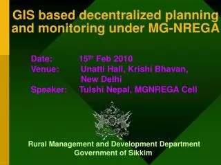
GIS based decentralized planning and monitoring under MG-NREGA. Date: 15 th Feb 2010 Venue: Unatti Hall, Krishi Bhavan, New Delhi Speaker: Tulshi Nepal, MGNREGA Cell. Rural Management and Development Department Government of Sikkim .

E N D
GIS based decentralized planning and monitoring under MG-NREGA Date: 15th Feb 2010 Venue: Unatti Hall, Krishi Bhavan, New Delhi Speaker: Tulshi Nepal, MGNREGA Cell Rural Management and Development Department Government of Sikkim
MG-NREGA GIS Initiatives • GIS based Monitoring system • Sub panchayat village base maps • Integration with socio economic data • SMS based micro monitoring system • GIS based Asset Management System
GIS based Monitoring System • GIS Base Maps prepared upto Sub-Panchayat level in 2008 • Maps prepared using 1:25000 SOI Toposheets • GIS Platform using latest software and hardware used • Terrain features over-layed from NASA maps • Integrated with Socio Economic Data from DESME Census 2006 and Census of India-2001 • Will facilitate targeting the backward areas, rural planning and livelihood interventions
Districts: 4 Blocks: 26 Gram Panchayat Units (GPU): 163 Sub-Panchayat(GPW): 891
Rural Poverty Mapping Most Backward Villages (More than 60% Households are BPL) WEST Deythang Parengaon Suntoley Deythang-Maneydara Ferek Nazar-Bertok SouthEast Manghim Beng Bering Thasa Khairbotey
MGNREGS GIS Maps at GP Level Based on Monthly Progress Report (MPR) of March – 2009, maps of jobcards issued at Village level
SMS based Micro Monitoring System GRS will send the MGNREGA progress update data through SMS. SMS will be sent twice a month. This SMS will be received as an email The received data will be updated into the database. This data will be later used to update the GIS maps. These GIS Maps will be made available in the official website
GIS based Asset Management System Each Block has already been provided with a hand held Garmin GPS On a monthly basis the Block office will prepare an inventory of MG-NREGA assets using GPS Based on these GPS points, GIS map will be prepared This map will help to keep track of different MG-NREGA assets
Thank You Mt. Khangchendzonga - The guardian deity of Sikkim