Download
1 / 32
320 likes | 465 Views
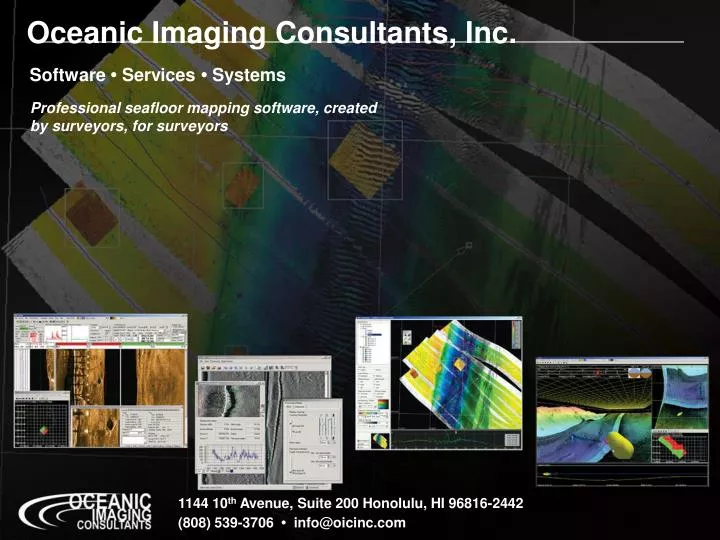
Oceanic Imaging Consultants, Inc. Software • Services • Systems. Professional seafloor mapping software, created by surveyors, for surveyors. 1144 10 th Avenue, Suite 200 Honolulu, HI 96816-2442 (808) 539-3706 • info@oicinc.com. GeoDAS: Geophysical Data Acquisition System.

E N D
Oceanic Imaging Consultants, Inc. Software • Services • Systems Professional seafloor mapping software, createdby surveyors, for surveyors 1144 10th Avenue, Suite 200 Honolulu, HI 96816-2442 (808) 539-3706 • info@oicinc.com
What is GeoDAS? • Geophysical Data Acquisition System Not the sonar… …but rather the survey system.
GeoDAS Development • Begun in 1994 • Purpose-built software for quantitative seafloor mapping • Designed for new breed of digital sonars: EdgeTech DF-1000, Ultra, etc. • POSIX-compliant, UNIX OS, C/C++ • Adapted by USN in 1995 • Ported to Windows in 1998
GeoDAS:Geophysical Data Acquisition System Data goes in, pictures come out • Data Input OIC Software Output Navigation Media Sidescan Printers Sub-Bottom Bathymetry Final Maps Magnetometry
GeoDAS Design Philosophy • Never lose data – 24/7/365 logging • Always log RAW data • Process data in real-time • Time-stamp to 1 ms • Geo-code (mosaic) in real-time • Built-in measurement, targeting, database, reporting, mission utilities
What can GeoDAS do for you? • Interface to sensor(s) • Log Raw Data & NAV • Enhance Imagery • Suppress Artifacts • Calculate altitude • Mark Targets • Show Coverage • Display Charts • Archive Data • Print Data
What ELSE can GeoDAS do for you? • Real-time integration of • Sensor navigation & attitude • with • Real-time processed sonar data • Means: • Real-time mosaicking
Supports Data Acquisition & Real-Time Processing from a Wide Range of Sensors: • Sidescan • All Benthos/Datasonics • All Edgetech • All Klein • Tritech • C-Max • Imagenex • Edo • SeaScan (Korea) • All MSTL • Any analog 2/4 channel
Supports Data Acquisition & Real-Time Processing from a Wide Range of Sensors: • Sidescan • Multi-beam • All RESON SeaBat • All SIMRAD EM series • Odom Echoscan • Seabeam/Elac • Atlas Hydrosweep
Supports Data Acquisition & Real-Time Processing from a Wide Range of Sensors: • Sidescan • Multi-beam • Interferometric • All SeaMARC Series • All Ultra Deepscan • RDI BSSS • TAMU-TAMU • Submetrix • AMS 50/60/120 • Benthos C3D (soon)
Supports Data Acquisition & Real-Time Processing from a Wide Range of Sensors: • Sidescan • Multi-beam • Interferometric • Optical • Raytheon Laser Linescan
Supports Data Acquisition & Real-Time Processing from a Wide Range of Sensors: • Sidescan • Multi-beam • Interferometric • Optical • Raytheon Laser Linescan • Electronic Still Cameras
Supports Data Acquisition & Real-Time Processing from a Wide Range of Sensors: • Sidescan • Multi-beam • Interferometric • Optical • Raytheon Laser Linescan • Electronic Still Cameras • “Streak LIDAR” • laser imaging plus • bathymetry!
After SAS Before SAS Additional Processing Options:SAS • GeoDAS for Synthetic Aperture Sonar, with DTI & Ultra (UK)
GeoDAS comes in a variety of packages: • Rack-Mount: • Dual processor; removable 36 GB HDD, MO or tape drive; 1280x1024 graphics, 1 GB RAM, Gigabit Ethernic; 18.1” screen; Windows 2000; Options: Quad processors, media drives, HDD, multi-port Ethernet, up to 2GB RAM • Lunch-Box: • Single processor, 18GB HDD; CD-RW; 1280x1040 graphics; 256MB RAM; 17.1” screen; removable keyboard; 10/100 Ethernic; Windows 2000 or NT; Option: second HDD or MO • Laptop: • Single processor; 60GB HDD; 768MB RAM; 6 serial ports; 10/100 Ethernic; 1024x768 graphics; Windows 98, 2000 or NT
New GeoDAS Features: • Electronics Charts: DNC, S-57, BSB, ARCS
New GeoDAS Features: • Survey / way-point Layout (2-D)
New GeoDAS Features:SmartSonar • Issues: • Sensor complexity overwhelms operators • Too much to adjust: range, gain,pulse-width, etc • Operators may not be present (AUV) • how do we tune for unknown terrain? • Better raw data would give better input to ATAR • And give better raw data for survey • SAS makes ATAR mandatory • If we can detect in raw element data, may not even need SAS • Status: • CEROS (Centers of Excellence for Research in Ocean Sciences) (DARPA $$) funded development of automatic sonar tuning, and target recognition • Scheduled for release Fall of 2005
New GeoDAS Features: ROVer’s Eye Seabed visualization for Mission Planning / Execution ROVer’s Eye GUI, showing Klein5500 data over Reson 8101 bathymetry
An example of Survey Planning and Execution with GeoDAS and ROVer’s Eye
Mission Planning & Execution: Step 1: Select your region of interest • Point and Click on a location on one of several user selectable base maps
Mission Planning & ExecutionStep 2: Zoom in • Zoom in to map limits to refine selection
Mission Planning & ExecutionStep 3: Refine selection from chart • Charts, if available, are auto-loaded to help define area • (DNC, S-57, BSB, etc.)
Mission Planning & ExecutionStep 4: Name/Define Project • Supply a project name, description, sampling/logging requirements, and refine position/ROI
Step 5: Background bathymetry loaded in ROVer’s Eye: • Digital Bathymetric DataBase, Variable res. (DBDBV) included with GeoDAS, along with World Vector Shoreline data
Step 5 Option: User-supplied Data • Optionally, user supplies their own hi-res bathy data
Step 6: Add a vehicle and point of View • Optionally adjust “bird’s” height
Step 7: Add Look-ahead Profile • Look-ahead view, w/adjustable range, min/maxZ, & warnings
Step 8: Add HUD • Display graphics for heading, Pitch, Roll & Position
Start Your Survey! • Update model on the fly with real-time data from vehicle
GeoDAS Summary: • GeoDAS available now, 100+ installations • Sidescan • Sub-bottom • Multibeam • Laser Linescan • Synthetic Aperture Sonar • 24/7/365 Raw data logging • Capable of handling up to 18MB/sec • Realtime processing: • Artifact removal, shading corrections • Full nav. support, user selectable co-ords. • Full attitude & geocoding at 30 Hz • Realtime and Post-processed mosaics • Options: • Desktop, ROVer’s Eye, OICclass, OICPipeTrack, OIC CleanSweep