Natural Resource Working Group:
130 likes | 247 Views
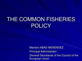
This initiative focuses on improving natural resource management and monitoring in Namibia through the utilization of GIS technology and community-based strategies. Key activities include mapping conservancy boundaries, implementing event books for data collection, conducting game counts, and providing technical support and training to community game guards across various regions. Collaboration with local entities like NACSO, MET, and IRDNC ensures holistic management approaches. Continuous development of training materials and support systems aims to foster sustainable practices and enhance the effectiveness of the Community-Based Natural Resource Management (CBNRM) programme.

Natural Resource Working Group:
E N D
Presentation Transcript
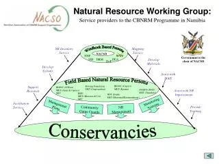
NR Inventory Service Mapping Service WWF Monitoring Systems NR Management Community Game Guards Windhoek Based Persons NACSO NNF Develop Materials Assist with M&E SSS DRM DEA DoF Develop Systems Provide Training Field Based Natural Resource Persons Facilitation Service Support Research IRDNC (Caprivi) MET (Katima) Rössing Foundation MET (Ongwendiwa) IRDNC (N/West) MET (Outjo & Opuwo) SRT Assist with NR Improvement NNDFN (NNC) MET (Tsumkwe) RISE MET (Khorixas & Uis) SRT NDT (South) MET (Mariental/Keetmanshoop) Management Plans Conservancies Natural Resource Working Group: Service providers to the CBNRM Programme in Namibia Government is the chair of NACSO
NR Management Mapping Natural Resource Management & Monitoring Monitoring NR Inventory Management plans Research Community Game Guards Areas of Activity
Monitoring • Event books introduced in Omatendeka and follow-up in Ehirovipuka. • Follow-up in all East Caprivi conservancies – this was a mid-year review for 6 conservancies/emerging conservancies. • Evaluation of Tsiseb (RISE) • Initiated event book at Otjimboyo (Swakop MET support) • Filing system initiated in Caprivi
Mapping • Boundaries for two new conservancies in process of being mapped in Otjouzondjupa. • Boundary maps and descriptions have been completed for 3 conservancies in Kunene – Ozondundu, Okangundumba and Anabeb. • Tracks and features mapped in Sorris Sorris – supported by MET. • Mapping support to NACSO partners – e.g. Lodge development in north-west. • Ortho-photos processed for the north.
Game Counts • Counts undertaken in Caprivi conservancies. NRWG in partnership with IRDNC provided technical support. • North-west count.
Support to MET • Incident book for protected areas in north-east. • Follow-up GIS support to Katima and Rundu. • Briefing document on the impacts of trophy hunting in the north-west. • Busy working with DSS and P&W Management Manual for THE UTILIZATION OF GAME IN CONSERVANCIES • Establishing GIS for MET Tsumkwe office. • Processed ortho-photos for rhino census.
Central Windhoek Node: • Provides roll-out systems and baseline-data • Provides technical support • Provides and facilitates training • Provides incentives for data sharing • Maintains data standards, directory structures, metadata • Acquires support for GIS development and provides grants to regional nodes • Coordinates regional GIS activities • Regional User Nodes: • Essentially end users – practical people who occasionally use GIS in their daily work • Depend on central support for training, baseline data, etc. Support strategy for GIS in Namibia
Other Activities • Participation in WSSD through GISD alliance • Benefits include: • Raising profile of CBNRM • Software • Geo-spatial resources • Webmapping and training