Directions to 36th Engineer Group Headquarters - Building 2885
Find step-by-step driving directions to reach the 36th Engineer Group Headquarters located at Building 2885 in Fort Benning, including landmarks and street names along the route.

Directions to 36th Engineer Group Headquarters - Building 2885
E N D
Presentation Transcript
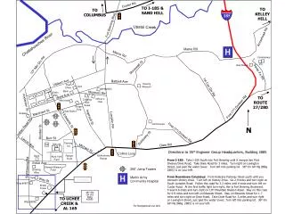
Custer Rd 185 H H TO I-185 & SAND HILL TO KELLEY HILL TO COLUMBUS Fort Benning Blvd Upatoi Creek Arrowhead Rd Chattahoochee River Marne Rd Marne Rd Commissary 10th Mtn Div Rd PX Gas Station Stonewall St Sante Fe Rd Vibbert Ave Baltzell Ave Infantry Museum Post Office Gym WHINSEC 1st Cav Div Rd Bank Wold Ave Morrison Rd Olsen Hall TO ROUTE 27/280 Officer’s Club Clothing and Sales Mini-mall Anderson St First (1st) Division Rd Burger King Marchant St Gas Station Subway Ingersoll St Lumpkin Rd Edwards St Golf Course Indian Head Rd N Riordan St First (1st) Division Rd Dublinsky St Burr St Parking Lot Bldg #4 Dixie Rd #6 Lavoie Ave Michael St Directions to 36th Engineer Group Headquarters, Building 2885 From I-185: Take I-185 South into Fort Benning until it merges into First Division/Dixie Road; Take Dixie Road for 3 miles. Turn right on Lexington Street, just past the water tower. Turn left into parking lot. 36th En GP HQ (Bldg 2885) is on your left. From Downtown Columbus: From Veterans Parkway travel south until you intersect Victory Drive. Turn left on Victory Drive. Go 2.9 miles and turn right on South Lumpkin Road. Follow this road for 3.2 miles until it ends and turn left on Custer Road. At the first traffic light turn right, this is Fort Benning Boulevard. Travel 0.6 miles and turn right on 10th Mountain Division Road. Stay on this road for 0.9 miles and turn left on Edwards Street. Stay on Edwards Street for 1.7 miles and turn right on Dixie Road. Take Dixie Road for .5 miles and turn right on Lexington Street, just past the water tower; Turn left into parking lot. 36th En GP HQ (Bldg. 2885) is on your left. Collins Loop McAndrews Range Ranger Field Bank Alvin York Field Eckel Ave Sightseeing Rd Stewart/Watson Field 250’ Jump Towers Bowling Alley Martin Army Community Hospital Gym See Detail Way St Bldg #2827 Water Tower 36th EN GP HQ Bldg #2885 TO UCHEE CREEK & AL 165 Bldg #2895 For Navigational Use Only
36th EN GP HQ 36th EN GP Warrior Dining Facility Parking