Download
1 / 10
130 likes | 319 Views
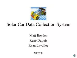
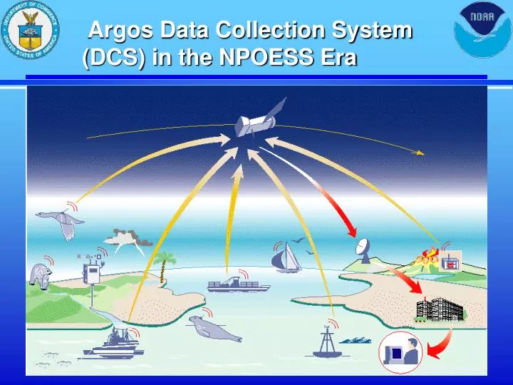
Argos Data Collection System (DCS) in the NPOESS Era. Argos Data Applications. Land Stations 10%. Ocean Floats 11%. Fisheries 9%. Moored Buoys 5%. Hazmat 4%. Ships 5%. Birds 7%. Drifting Buoys 27%. Marine Animals 7%. Land Animals 6%. Expeditions 9%. Major Users.

E N D
Argos Data Applications Land Stations 10% Ocean Floats 11% Fisheries 9% Moored Buoys 5% Hazmat 4% Ships 5% Birds 7% Drifting Buoys 27% Marine Animals 7% Land Animals 6% Expeditions 9%
Major Users • Department of Commerce/NOAA • OAR • NWS • NMFS • Department of Defense • Foreign Governments • Researchers/Universities
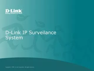
METOP DMSP 0830 1330 0930 0530 POES Local Equatorial Crossing Time DMSP Tomorrow (2005) • 4-Orbit System • 2 US Military • 1 US Civilian • 1 METOP BackgroundSatellite Evolution DMSP/POES NPOESS METOP POES NPOESS NPOESS Today • 4-Orbit System • 2 US Military • 2 US Civilian DMSP 0730 0530 1330 1330 0930 0830 0530 POES Local EquatorialCrossingTime Local Equatorial Crossing Time NPOESS Lite DMSP Future (2008-2018) • 3-Orbit System • 2 US Converged • 1 US “Lite” • 1 METOP
National Polar-orbiting Operational Environmental Satellite System • 2008-2018 …. Timeframe • Converges Civil and Defense Requirements • Leverages EU Cooperation • Opportunity for Argos enhancements
Current Program Status • NOAA/CNES Letter of Intent recognizing interest in continued cooperation beyond NOAA-N’ • NOAA/CNES meetings in March, June, October 2002 to discuss Argos requirements for NPOESS • NPOESS Contract Awarded
DCS Requirements Identification • Argos • User Surveys • 1995 requirements flying in 2008 / NOAA N' • Conducting survey of wildlife / low power applications • User Group Conferences • DBCP • International Argos Users Conference March 2001 • User Visits • Transmitter Manufacturers • Universities • Ocean U.S.
Future Argos DCS Requirements • Qualitative vs. Quantitative • JCOMM Cross-cutting issue/NESDIS Sr Scientist • More data transmission capability • Recommends workshop to define future requirements • DBCP baseline survey of developments in satellitecommunication systems • Commercial market not optimized for Ocean Observations
Argos User Role • “Brain-Storm” Possible Enhancements • Document Anticipated Requirements • Establish Argos Interest Group for NPOESS? - Robert.Bassett@noaa.gov
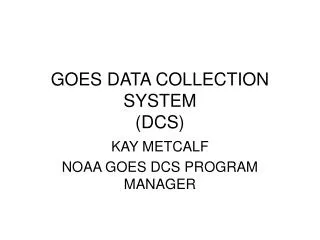
NPOESS Payloads NPOESS Lite 0930 NPP NPOESS Instruments 0530 0930 1330 TBD 1030 IPO Developed Visible/IR Imager Radiometer Suite (VIIRS) X X X (AVHRR) X Cross-track IR Sounder (CrIS) X X (IASI/HIRS) X Conical MW Imager/Sounder (CMIS) X X X Ozone Mapper/Profiler Suite (OMPS) X X (GOME) X GPS Occultation Sensor (GPSOS) X X X (GRAS) Space Environmental Sensor Suite (SESS) X X X (SEM) Aerosol Polarimeter Sensor (new) X Leveraged Advanced Technology MW Sounder (ATMS) X X (AMSU/MHS) X Data Collection System (DCS) X X X Search and Rescue (SARSAT) X X X Earth Radiation Budget Sensor X Solar Irradiance Sensor (TSIS) X Radar altimeter (ALT) X Advanced Scatterometer (ASCAT) X METOP 10