Download
1 / 1
10 likes | 182 Views
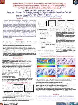
Low-level liquid cloud. Developing cloud. Mature cloud. Drizzling, but no rain. Raining. Enhancement of Satellite-based Precipitation Estimates using the Information from the Proposed Advanced Baseline Imager (ABI) Part II: Drizzle Detection and Warm Rain Retrieval.

E N D
Low-level liquid cloud Developing cloud Mature cloud Drizzling, but no rain Raining Enhancement of Satellite-based Precipitation Estimates using the Information from the Proposed Advanced Baseline Imager (ABI) Part II: Drizzle Detection and Warm Rain Retrieval Ruiyue Chen, Fu-Lung Chang, Zhanqing Li Cooperative Institute for Climate Studies (CICS) University of Maryland College Park, MD Ralph Ferraro, Robert Kuligowski NOAA/NESDIS/Center for Satellite Applications and Research Introduction Traditional IR and microwave techniques have problems in detecting rain associated with warm cloud tops (i.e., “warm rain”), which is very important for both synoptic and climate scale precipitation analyses. This investigation presents an algorithm to detect drizzle and retrieve warm rain with cloud information including cloud droplet effective radius (DER) profile, cloud top temperature, and liquid water path (LWP). The cloud information is obtained through applying Chang and Li’s [2002, 2003] algorithm to the NASA Moderate Resolution Imaging Spectroradiometer (MODIS) on the AQUA satellite, which also carries the Advanced Microwave Scanning Radiometer (AMSR-E). The microwave observations of AMSR-E contain information on precipitation. By analyzing the products of MODIS and AMSR-E, we will show that the vertical variation of cloud DER is effective to identify raining/non-raining clouds, and warm rain can be retrieved with this cloud information. The algorithm could be applied to the GOES-R ABI, which has all the required channels. Warm Rain Retrieval d a b c Fig. 3 Mean rain rate for a) mean vertical DER variation in 2um interval b) mean DER at cloud base in 2um interval c) mean LWP on 0.08mm interval d) mean cloud top temperature in 2oC interval • Fig. 3 shows warm rain rate is correlated with cloud top temperature, LWP, DER profile, and DER at cloud base • Cloud top temperature represents the available supersaturated water vapor for droplet growth • LWP represents the amount of liquid phase water for rain production • DER profile represents the droplet growth rate • DER at cloud base represents the droplet size at cloud base • Regression with AMSR-E rain rate results • 20 is raining critical value of DER at cloud base • 30 is up-limit of cloud top temperature • represents the efficiency of rain production from cloud LWP N Y Motivation • Warm rain is derived from warm top cloud and does not involve ice-phase processes. It is generally one order of magnitude smaller than cold rain but occurs much more frequently. • Warm rain plays an important role in atmosphere and water circulation. • IR techniques depend on cloud top temperature and can not detect warm rain. • Passive microwave depends on cloud ice scattering and can not detect warm rain over land. Over ocean, it depends on rain emission and physically sensitive to warm rain, but it may miss many light warm rain with small area coverage due to its large field of view and low sensitivity. • This study estimates warm rain from cloud information retrieved by Chang and Li’s algorithm [2002 2003]. The algorithm is calibrated with passive microwave retrieved rain rate from low level overcastcloud over ocean. N Y Fig. 4 Algorithm for drizzle detection and warm rain retrieval A comparison with IR and Passive Microwave techniques Data and Method MODIS data (low level liquid cloud on 01/01/2003 over40oN~60oS ) • Optical depth is retrieved with a visible channel (0.64μmfor land surface, 0.86μm for ocean surface). • Cloud top temperature is retrieved with IR window channel (11μm). • 3.7μm, 2.1μm, 1.6μm, and the visible channel are utilized to retrieve DER profile, which is defined by re1(DER at cloud top) andre2(DER at cloud base) • The DER profile is utilized to calculate LWP with a b • DER at cloud base shows a wider spectrum than DER at cloud top. DER at cloud base is small for developing cloud and large for mature cloud. • AMSR-E data • AMSR-E Rain rate estimation on 01/01/2003from GPROF algorithm. c d Fig.1 Probability Density Function of re1 and re2 Fig.5 Global distribution within 1x1 degree grid boxes of a) cloud top temperature b) Rain rate from AMSR-E c) Fraction of cloud with drizzle but no rainfall d) Warm rain rate from MODIS cloud information MODIS cloud parameters are matched to AMSR-E footprint covered by low level, liquid, and overcast cloud • IR techniques utilize cloud top temperature and miss all warm rain • Microwave techniques measure cold rain globally & part of warm rain (overcast/heavy) over ocean • Average AMSR-E rain rate is 0.09mm/hr and occurs within 26% of grid boxes • Average MODIS warm rain rate is 0.013 mm/hr and occurs within 52% of grid boxes • 38% of grid boxes have MODIS warm rain but no AMSR-E rain. These boxes contribute 0.007 mm/hr warm rain to MODIS. This means AMSR-E misses more than 54% warm rain, because AMSR-E must also miss some warm rain in the other 14% grid boxes that contain MODIS warm rain. Raining/Non-raining Cloud Identification a c b Fig.2 Occurrence frequency of DER for raining/non-raining cloud a) DER at cloud top b) DER at cloud base c) Vertical DER variation References Chang, F.-L., Z. Li, 2003, Retrieving the vertical profiles of water-cloud droplet effective radius: Algorithm modification and preliminary application, J. Geophy. Res., 108, D(24), 4763, 10.1029/2003JD003906. Chang, F.-L., Z. Li, 2002 Estimating the vertical variation of cloud droplet effective radius using multispectral near-infrared satellite measurements, J. Geophy. Res., 107, 10.1029 /2001JD0007666, pp12. • The larger DER, the more opportunity of raining. DER at cloud base (re2) larger than 20um indicates rain. • Physically, means droplet at cloud top drizzles, but it may evaporate and can not form rain unless the DER at cloud base is large enough