PROTOTYPE FLOW
IN21B-1054. ICAN Ontology. Mappings. MIDA Ontology. OCA Ontology. X Ontology. IN21B-1054. Interoperability Between Coastal Web Atlases Using Semantic Mediation: A Case Study of the International Coastal Atlas Network (ICAN)

PROTOTYPE FLOW
E N D
Presentation Transcript
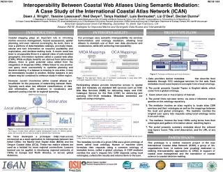
IN21B-1054 ICAN Ontology Mappings MIDA Ontology OCA Ontology X Ontology IN21B-1054 • Interoperability Between Coastal Web Atlases Using Semantic Mediation: A Case Study of the International Coastal Atlas Network (ICAN) • Dawn J. Wright1, Yassine Lassoued2, Ned Dwyer2, Tanya Haddad3, Luis Bermudez4, Liz O’Dea5, Declan Dunne2 • Department of Geosciences, Oregon State University, dawn@dusk.geo.orst.edu; 2)Coastal and Marine Resources Center, Cork, IRELAND, Y.Lassoued@ucc.ie, D.Dunne@ucc.ie, N.Dwyer@ucc.ie 3) Oregon Coastal Management Program, Portland, OR, tanya.haddad@state.or.us; 4) Southeastern Universities Research Association, (SURA),bermudez@sura.org; 5) Washington Department of Ecology, Olympia, WA, lode461@ecy.wa.gov • American Geophysical Union Fall Meeting, December 15, 2009, San Francisco, CA • Session IN21B: Strategies for Improved Marine and Synergistic Data Access and Interoperability … INTRODUCTION INTEROPERABILITY PROTOTYPE FLOW Coastal mapping plays an important role in informing marine resource management, hazard assessment, spatial planning, and even national sovereignty. As such, there is now a plethora of data/metadata catalogs, pre-made maps, tabular and text information on resource availability and exploitation, and decision-making tools. A recent trend has been to encapsulate these in a special class of web-enabled geographic information systems called a coastal web atlas (CWA). While multiple benefits are derived from tailor-made atlases, there is great potential value added from the integration of disparate CWAs. CWAs linked to one another can query more successfully to optimize planning and decision-making. If a dataset is missing in one atlas, it may be immediately located in another. Similar datasets in two atlases may be combined to enhance study in either region. Our prototype uses semantic interoperability via services harmonization and ontology mediation, allowing local atlases to maintain use of their own data structures and vocabularies, while still achieving interoperability. Mapping Example: ICAN: “Seabed” is similar to OCA: “Seafloor” MIDA Mappings OCA Mappings CSW WMS WFS CSW WMS WFS CSW WMS WFS X … Figure 4.Prototype architecture and future directions • Data providers deliver metadata records that describe their datasets through OGC catalogue services for the web. Each metadata record uses keyword concepts from a local ontology. • The portal presents Coastal Topics in English labels, which come from a global ontology. • Users select one or more topics of interest. • The portal finds narrower terms, via Jena 2 inference engine queries on the ontology repository. • The mediator invokes an atlas registry to locate atlas CSW services and their ontologies as well as the mappings between the local and global ontologies. The mediator rewrites the original user query into requests using local ontology terms from each atlas. • The mediator invokes the local CSWs using terms from their ontologies and gathers information about matching layers. • The portal presents summary metadata about the relevant map layers found: Title, brief description, and the URL of any WMS. Figure 2. The approach makes use of controlled vocabularies in local atlas OWL ontologies mapped to terms in a super ontology However, current inventories within coastal atlases are insufficient for the purposes of networking between them. Typically each atlas has different classifications of data and information, with variations in vocabulary and approach posing a barrier to regional querying. Participating atlases provide interactive access to spatial data and metadata via standard GIS services such as OGC Web Map Services (WMS) for delivering maps, and OGC Catalogue Service for the Web (CSW) for delivering and querying ISO-19139 metadata. Metadata semantics are captured using ontologies. Global atlas Global • <PropertyIsLike wildCard="%“ singleChar="_" escape="\"> • <PropertyName>keyword</PropertyName> • <Literal>HumanResponsesToCoastalChange%</Literal> • </PropertyIsLike> Local atlases … • <Or> • <PropertyIsLike wildCard="%“ singleChar="_" escape="\"> • <PropertyName>keyword</PropertyName> • <Literal>CoastalProtection%</Literal> • </PropertyIsLike> • <PropertyIsLike wildCard="%“ singleChar="_" escape="\"> • <PropertyName>keyword</PropertyName> • <Literal>CoastalDefenceStructure%</Literal> • </PropertyIsLike> • </Or> … MIDA Figure 1. Established coastal web atlases such as the Marine Irish Digital Atlas, and the Oregon Coastal Atlas address coastal management topics for distinct spatial areas, but currently do not have the ability to network their inventories. Figure 3. The semantic mediator re-writes query terms so that local data can be found using terms in the super ontology We have developed a prototype (http://ican.ucc.ie/) envisioned as a seed application to interoperate between two initial CWAs: the Marine Irish Digital Atlas (MIDA) and the Oregon Coastal Atlas (OCA). These two mature atlases are used as a testbed for more regional connections. Lessons learned can be applied in developing regional networks of CWAs in Europe and North America, or across global distances. PARTICIPANTS The metadata records of a given CWA use a given ontology of terms called local ontology. Human or machine users formulate their requests using a common ontology of metadata terms, called a global ontology. A CSW mediator rewrites the user’s request into CSW requests using local ontologies, collects the results and returns them to the user. This prototype is a central research project of the new International Coastal Atlas Network (ICAN), a group of 30+ organizations from 14 nations (and growing) dedicated to seeking interoperability approaches to CWAs in support of coastal zone management and the translation of coastal science to coastal decision-making.