Working with Elevation Services
Explore the capabilities of ArcGIS Online World Elevation Services and Terrain 3D cache for 3D visualization and geoprocessing. Learn about data sources, tools, and client applications, modes of use, and technical aspects. Access public domain elevation data and geoprocessing services, including creating on-the-fly products. Discover different usage modes such as visualization, data values, and geoprocessing. Connect and use services in ArcGIS Online, ArcMap, and ArcGIS Pro. Access resources like FAQs, recorded seminars, and join the World Elevation group for more insights.


Working with Elevation Services
E N D
Presentation Transcript
Working with Elevation Services Cody Benkelman
Outline • ArcGIS Online World Elevation & 3D Elevation Cache for Pro • What is included? • Data and Tools • How can I use it? • Modes of use • Client Applications • What are the details? • Technical and Legal
ArcGIS Online World Elevation & “Terrain 3D” for 3D Visualization • ArcGIS Online World Elevation • Supports analysis & visualization • Accessed using REST calls defined by REST API (2D AOI, polyline, or points…) • Terrain 3D cached elevation service • Optimized to quickly generate an oblique 3D perspective view (multiresolution) • Not intended for analysis • Automatically connected into ArcGIS Pro
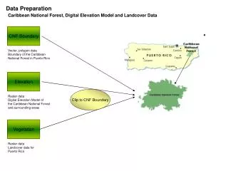
Contents ArcGIS Online World Elevation Data sources, Functions, and Geoprocessing Services
World Elevation Services - Data Sources Public domain elevation data – 2+ TB (LZW compressed TIF) 1 km Bathymetry (GEBCO) 250m GMTED 90 m SRTM & EarthEnv-DEM90 60 m NED (AK) 50 m OS (UK) 30 m SRTM (most of world) 30 m NED (North America) 10 m (USA, Norway, Austria) 3 m (partial USA, Denmark, Finland) 2 m (partial UK) …more coming each year
Services (as viewed in ArcMap) • Image service: elevation values & derived products • Terrain • TopoBathy • Dedicated NED 30m (USA) • Server-side Geoprocessing (GP) services • Profile • Summary Statistics • Viewshed • Watershed (Hydro) • Trace Downstream (Hydro)
Contents – World Elevation as an image service Elevation products available on demand using Raster Functions as Processing Templates Default is Terrain (orthometric height, 32 bit float) 9 Functions to create on-the-fly products
Modes of Use ArcGIS Online World Elevation
“How can I use these services?” • Usage Modes • Visualization • Data Values • Geoprocessing • Client Applications • ArcMap, ArcGIS Pro, ArcGIS Online, Custom web apps • End Users vs. Developers
Usage Modes • Visualization • Hillshade (Grayscale, Elevation Tinted) • Slope Map & Aspect Map
Usage Modes • Visualization • Hillshade (Grayscale, Elevation Tinted) • Slope Map & Aspect Map • Data Values • Orthometric & Ellipsoidal Height - for Orthorectification, Local Analysis… • Slope & Aspect
Usage Modes • Visualization • Hillshade (Grayscale, Elevation Tinted) • Slope Map & Aspect Map • Data Values • Height • Slope & Aspect • Server-side Geoprocessing Services • Viewshed, Profile, Statistics, Watershed, Trace Downstream
Client Applications • ArcGIS Online web map
Client Applications • ArcGIS Online web map • ArcGIS Pro, ArcMap (10.1.1 or later)
Client Applications • ArcGIS Online web map • ArcGIS Pro, ArcMap (10.1.1 or later) • Custom web applications • Cartography • Data for elevation analysis • Custom geoprocessing • ArcGIS API’s vs. OGC (WMS, WCS – limited functionality)
Connecting and Using • Start in ArcGIS Online Group: “Elevation Layers” • Base image service is “Terrain” • Or choose layer preconfigured with Raster Function
Connecting and Using • Start in ArcGIS Online Group: “Elevation Layers” • Base image service is “Terrain” • Or choose layer preconfigured with Raster Function • Start in ArcGIS Online Web Map • “Add” from Living Atlas, “Terrain” • OR Start in ArcMap/ArcGIS Pro • “Add Data” from ArcGIS Online, “Terrain”
Connecting and Using • Start in ArcGIS Online Group: “Elevation Layers” • Base image service is “Terrain” • Or choose layer preconfigured with Raster Function • Start in ArcGIS Online Web Map • “Add” from Living Atlas, “Terrain” • OR Start in ArcMap/ArcGIS Pro • “Add Data” from ArcGIS Online, “Terrain” • Authentication required • ArcGIS, AGOL map: • ArcGIS Online Subscription Account • Custom REST-based apps • Acquire token • Pass token in REST request
Using geoprocessing services For frequently used analytical tasks, data manager can publish geoprocessing services. No need to export a copy of the data – User defines processing parameters Server extracts imagery & runs process Summary result returned to user (JPG image, table of points, feature class, etc.)
Details… ArcGIS Online World Elevation
Terms of Use • ArcGIS Online Subscription account • Services with no cost in terms of AGOL Credits: • Image services & functions (elevation, hillshade etc.) • ElevationSync analysis: Profile • Geoprocessing services that will consume Credits: • Hydrology analysis: Trace Downstream and Watershed • Elevation analysis: Profile, Summarize Elevation, and Viewshed • 1 credit per 1000 features!
Resources Open for questions… World Elevation group on ArcGIS Online: http://esriurl.com/6548 FAQs for World Elevation services: http://esriurl.com/ElevationFAQ Recorded Seminar: Elevation Analysis with ArcGIS Online http://esriurl.com/ElevationLTS For developers: AGOL elevation analysis: https://developers.arcgis.com/rest/elevation/ Export AOI: http://esriurl.com/ImageServiceREST Community Elevation Contributions: http://esriurl.com/CommunityElevation cbenkelman@esri.com
Please take our Survey Your feedback allows us to help maintain high standards and to help presenters Find your event in the Esri Events App Find the session you want to review Scroll down to the bottom of the session Answer survey questions and submit