Download
1 / 38
520 likes | 912 Views
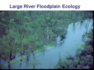
River Ecology and Environmental Flows. Eric S. Hersh The University of Texas at Austin Center for Research in Water Resources Arc Hydro River Workshop December 1, 2010. Outline. Context within Arc Hydro River Motivation Environmental Flows Flow Biota Habitat. Arc Hydro River.

E N D
River Ecology and Environmental Flows Eric S. Hersh The University of Texas at Austin Center for Research in Water Resources Arc Hydro River Workshop December 1, 2010
Outline • Context within Arc Hydro River • Motivation • Environmental Flows • Flow • Biota • Habitat
Arc Hydro River Maidment and Brown, 11/24/2010 • river network component • 3D river channel • flood modeling and mapping component • river ecology and morphology component • characterization of stream habitat • mapping of fish and biota distributions • morphological description of stream environments • characterization of the sediment characteristics of the river, its bed and banks
Arc Hydro River • river network component • 3D river channel • flood modeling and mapping component • river ecology and morphology component • Goal: to facilitate the characterization, classification, mapping, and bioassessment of fish and biota in the riverine and riparian zones to support conservation and wise use
? The study of ecology requires (and adds) complexity and nuance
Outline • Context within Arc Hydro River • Motivation • Environmental Flows • Flow • Biota • Habitat
Too little water Too much water Water environment Water quality
Flow Biota Habitat … and water quality
Ecosystem Services • Fish and wildlife: biodiversity, conservation, habitat • Endangered species protection • Fisheries (commercial and recreational) • Navigation • Hydropower • Recreation • Ecotourism • Waste assimilation • Water supply • Food supply • Flood and drought mitigation • Nutrient delivery • Sediment transport • Coastal salinity regulation • Aesthetics
Arc Hydro River From Robert Vertessy, CSIRO, Australia
Outline • Context within Arc Hydro River • Motivation • Environmental Flows • Flow • Biota • Habitat
Instream Flows Dr. Thom Hardy, Texas State University Instream Flows is the art and science of collecting data in systems we cannot adequately sample using methods developed by committees of technically unqualified participants for organisms we know very little about in order to form concepts about processes we do not fully understand that we represent as mathematical abstractions that we cannot precisely analyze to determine their responses to indeterminate stresses we cannot accurately predict now let alone in the future all in such a way that society at large is given no reason to suspect the extent of our ignorance.
Environmental Flows definition Brisbane Declaration 2007 “The quantity, timing, and quality of water flows required to sustain freshwater and estuarine ecosystems and the human livelihoods and well-being that depend on these ecosystems”
Texas Legislative Background • Freshwater inflow needs for bays & estuaries (1980s) • Senate Bill 1: water resource planning & management (1997) • Senate Bill 2: the science bill (2001) • Instream flow data collection and evaluation program • Methodologies to determine flow conditions in Texas rivers and streams necessary to support a sound ecological environment • Senate Bill 3: the implementation bill (2007) • The who, when, and how of eflowimplementation in Texas • TCEQ must adopt the recommended standards by June 2011
Outline • Context within Arc Hydro River • Motivation • Environmental Flows • Flow • Biota • Habitat
Rate of Change Magnitude Duration Timing the natural flow regime Not depicted: frequency
flow components (NRC 2005)
Current Treatment of Streamflow • NHDPlus attributes • ESRI Community Hydro Base Map • USGS Streamstats • The Nature Conservancy’s Indicators of Hydrologic Alteration (IHA) • USGS Hydrologic Assessment Tool (HAT)
Outline • Context within Arc Hydro River • Motivation • Environmental Flows • Flow • Biota • Habitat
The Water Environment • Distinct types of water data, each with its own character • Physical data describe the movement of water and its properties • Chemical data describe the constituents moving with, in, and through the water • Biological data describe the organisms inhabiting the water environment. Surveys Sensors Continuous Longitudinal Studies Samples Discrete Lateral phys/ chem biol vs.
The Data Cube S = f {x,y,z,t,v} Time, T “When” t A data value D “Where” s Space, S Vi “What” Variables, V
S = f {x,y,z,t,v} taxonomy 1a. generic data cube 1b. physical phenotype Measurements, traits, and characteristics, such as length, mass, sex, or count. 1d. biological 1c. chemical
Ontologies & Semantic Mediation eg: ‘reservoir inflow’ vs. ‘discharge’ http://test.hydroseek.net/ontology/CUAHSIOntologyMay2009.html
BioODM v.1.2 Eric S. Hersh, UT-CRWR 9/25/2009 Size Organism Weight Units (has traits, ID) Taxonomy Group (characteristics, statistics) Sample Method Site Habitat (specific location) (substrate, cover, hydraulics, characteristics) Source Document Domain (provenance, contact info) (link to pdf, geography) (general location) Datum
The hydroinformatics maturity ladder NODC, NCAR EOL Marine Biol. Aquatic Biol. FishBase, NTL, FBIS, private/internal NSF- NEON, LTER, NCEAS; NatureServe, GBIF Ecol. Info Decreasing maturity (Digital Libraries) 1990s; moderate commercial & open source; widespread investigation Conceptualized in 2000s by CUAHSI, an NSF-sponsored university partnership HIS GIS Maintains a mature commercial market. ESRI revenue of ~$800 million/year
metadata standards data centers • USGS National Biological Information Infrastructure (NBII) • Ecological Markup Language (EML) – data discovery/ flexible, vs. WaterML – data discovery and integration/ structured • Long-term Ecological Research sites (LTER) • National Center for Ecological Analysis and Synthesis (NCEAS) • National Ecological Observation Network (NEON) - sensors data models/ databases catalogs • NatureServe Biotics4 PDM • North Temperate Lakes LTER • NOAA NW Fisheries Science Center Aquatic Resources Framework • TetraTech EDAS • NZ NIWA Freshwater Biodata Information System • Ontario Ministry of Natural Resources Flowing Water Information System • Global Biodiversity Information Facility (GBIF) • FishBase – 33 million hits/mo
-Sabine River: 165 samples collected at 8 study reaches over 8 days in 2006; 147 samples yielded fish, averaging 40 fish per sample -5,811 fish were observed, representing 58 species -Across all sites, 889 Centrarchids (sunfish, bass, and crappies) were observed with a relative abundance of 22% ± 24% -The only non-native observed was the inland silverside (Menidiaberyllina). 192 total, ranging from 0-90% of the sample population with a mean of 3% ± 12% Distribution: Originally found in coastal waters and upstream in coastal streams along the Atlantic and Gulf coasts; widely introduced into freshwater impoundments (Hubbs et al. 1991) http://www.bio.txstate.edu/~tbonner/txfishes/menidia%20beryllina.htm
Inland Silverside Menidia beryllina Non-native species distribution
Outline • Context within Arc Hydro River • Motivation • Environmental Flows • Flow • Biota • Habitat
The 4-D Nature of Lotic Ecosystems Ward, JNABS, 1989
Fluvial coordinates • Rectangular coordinates (x,y,z) • Fluvial coordinates: • Dynamic wrt hydrology, geomorphology, but additional value derived • e.g.: was a DO sample taken near the surface? In the water column? At the sediment-water interface? In the pore space?
Habitat Complexities • 3-D channel representation • ArcScene? • Morphometry and geomorphology • Time-enabled feature class in ArcGIS 10? • Sediment, substrate, vegetation, cover • Observations and/or spatial data? Both/neither? • What is a river? • Ephemeral, intermittent, canals? NHDPlus as guidance? • GW-SW interaction, hyporheic zone • Interaction/ exchange with Arc Hydro Groundwater?
Concluding Thoughts with regards to river ecology… Arc Hydro River could provide a physical template for the riverine and riparian environment which would enable the storage and sharing of observations of the lotic ecosystem and thus would support analyses of flow-biota-habitat linkages