Download
1 / 21
210 likes | 416 Views
Case-Study : Use of satellite remotely sensed data integrated with livelihood information in support of food security monitoring and early warning in the Sool & Sanaag pastoral region of Somalia. Gideon Galu (USGS/FEWS NET) ( ggalu@fews.net ) Mohammed AwDahir (FEWS NET/FSAU)

E N D
Case-Study: Use of satellite remotely sensed data integrated with livelihood information in support of food security monitoring and early warning in the Sool & Sanaag pastoral region of Somalia Gideon Galu (USGS/FEWS NET) (ggalu@fews.net) Mohammed AwDahir (FEWS NET/FSAU) (mawdahir@fews.net)
Study Objective Demonstrate the use of satellite and available field information: Drought, Flood and Land-Cover Change Monitoring & its impact on Pastoral Livelihoods….
Justification Sool & Nugaal Pastoral Communities were at the brink of collapse…. (UN Inter-Agency Assessment Mission Report, 2003) This humanitarian crisis situation was linked to persistent drought affecting primary source of livelihoods of the local communities: transhumant pastoralism… (FSAU, 2001 & Horn Relief,2006) ……. seven failed rainfall seasons
Study Approach: Satellite + Field data inputs.. Determination of Drought Severity, Extent and Cycle(s) NOAA/NDVI (1982-2004) and MODIS/NDVI WRSI/Rangeland products (NEW) CPC/Rainfall Estimates Determination of Environmental Change and impact Landcover time-series change analysis (Landsat: 1986 - 2000) Human settlements and migration patterns Water points location and distribution Impact assessment of the recent drought on livelihoods Affected populations Income-sources Conclusion
Resources… http://www.fsau.org http://www.fews.net http://earlywarning.usgs.gov/ADDS +
Study Area : Sool & Sanaag Source: FSAU/FEWS NET
Food and Income Sources and Expenditure Source: FSAU/FEWS NET
Why Use Satellite Observation Trends? Satellite are good at monitoring change…and NOTAbsolute quantities…..
Threshold Threshold NDVI Departure from Normal(%): Drought Monitoring • 10 year severe drought-cycle (1981/3,1991/3, 2001/3). • Short-lived recovery periods. • Drought threshold of NDVI % dep. ≤ -10% for at least 2 years. Source: USGS/FEWS NET and FSAU publication
1996 – 2006 Rangeland/WRSI Anomalies (%) : Sool & Gebi Plateau Drought Monitoring Complete to partial failure Normal Failure WRSI Anom ≤ 50%, is failure for at least 2 years Source: USGS/FEWS NET
1996/2006 Rainfall Performance : Sool & NugaalFrom droughts to floods, a recurrent cycle? El-Nino 1997/8: Severe floods, Disease, Livestock Trade Ban 2004: Severe floods 2005/6: Brief Recovery Period ? 2001/3: Severe Droughts; 7-Failed Rainfall Seasons 2000: Brief Recovery Period Source: USGS/FEWS NET
2001/4 Rainfall Performance : Sool & Nugaal PlateauFrom droughts to floods, a recurrent cycle? • Complete to partial rainfall failure from Gu 2001 - Deyr 2003 • Drought threshold of RFE % dep. ≤ -50% for at least 2 years
Water Resource Monitoring Water is the most pressing humanitarian need…….. Cost of water rose by 350% Source: USGS/FEWS NET and UN Inter-Agency Assessment Report (2003)
The dominant land use / land cover types in this area are Shrublands, Woodlands, and Herbaceous Vegetation. Negative change in vegetation cover Landsat : 1986 – 2000 Sool & Nugaal Plateau Negative Land Cover Change Preliminary Analysis Results: …using simple band differencing method done using satellite images of the area acquired in 1986 and 2000, almost 38% (22,550 Km2) of the Sool Plateau has experienced negative change (RCMRD,2006)
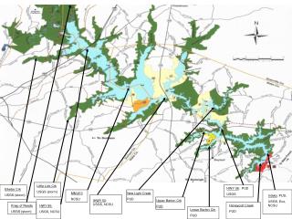
Proliferation of Water-points with MODIS/NDVI Background(Data Source: USGS/EDC, GTZ, SWIMS, SWALIM/Toposheet) More Dense in the relatively drier parts of the region Source: USGS/FEWS NET
Seasonal Livestock Migration Patterns(Data Source: FSAU/FEWS NET) Source: FSAU/FEWS NET
Estimated Population Distribution using Landscan (2005)(Data Source: Oak Ridge National Laboratory-ORNL)
Environmental Study of Degradation in the Sool Plateau & Gebi ValleySupported by Oxfam Netherlands: NOVIB • Confirms Land degradation possible due to: • Recurrent Drought & floods • Proliferation of water points • Increased Human settlements • Deforestation • Overgrazing Degraded prime grasslands of Bocooda Deforestation through charcoal burning at Galool (2005)
Impact on Livelihoods in 2001/3 • Livestock loss due to droughts/floods; 60 - 70% in 2001/3 • Decline in livestock sale prices;60 – 70 % • Decline in milk production ;little/no • Increased expenditure;water up by 350% • Inability to recover due to absence of successive good seasons; • Recurrent disasters have a negative impact on coping mechanisms as they limit coping options; increased charcoal burning, remittances and debts. • Environmental degradation limiting the capacity of land to support livestock and other productive activity; • Change in livelihood systems or destitution due to disasters ?
Impact on Livelihoods? Recurrent Droughts and Floods undermine livelihoods… Effects of Hazards on Income sources Environmental ‘Hazards’ Typical Year Land Degradation
CONCLUSION • Demonstrated potential use of freely available SRS and Field Information (LZ) in monitoring recurrent droughts, floods… • Potential wide application, in GHA pastoral regions.. • Need for long-term development initiative in these chronically food insecure areas..