Download
1 / 1
10 likes | 113 Views
Conserving San Francisco Bay's Waterbirds : three decades in a rapidly changing landscape. Vanessa Tobias 1 , Catherine Burns 2 , Cheryl Strong 3 , Orien Richmond 4 , Jill Demers 2 , John Takekawa 5 , and Emilio Laca 1

E N D
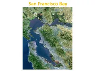
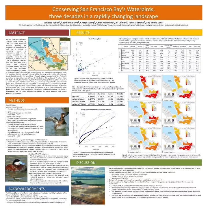
Conserving San Francisco Bay's Waterbirds: three decades in a rapidly changing landscape Vanessa Tobias1, Catherine Burns2, Cheryl Strong3, Orien Richmond4, Jill Demers2, John Takekawa5, and Emilio Laca1 1UC Davis Department of Plant Sciences, 2San Francisco Bay Bird Observatory, 3Don Edwards San Francisco Bay National Wildlife Refuge, 4Refuges Inventory & Monitoring Program, 5USGS Western Ecological Research Center. Contact email: vtobias@ucdavis.edu Table 2: Changes in average abundance of birds over all seasons, relative to 1980s counts. Positive values indicate increases since the 1980s; negative values indicate decreases. Percent change is calculated as the difference divided by average abundance from the 1980s, multiplied by 100%. The San Francisco Bay estuary provides critical habitat for over one million waterbirds annually. Although the landscape has been altered for well over a century by increasing levels of urbanization, and by the historic establishment of evaporator ponds for salt production, it remains heavily used by waterbirds. The area also hosts the west coast’s largest tidal wetlands restoration project; the South Bay Salt Pond Restoration Project is implementing a plan ABSTRACT METHODS RESULTS DISCUSSION ACKNOWLEDGEMENTS Map: www.southbayrestoration.org to convert thousands of acres of salt ponds into tidal and managed wetland habitat. While the restoration to tidal marsh will increase habitat for many species, it also will reduce the overall habitat available for waterbirds. Through adaptive management, the Project is committed to maintaining historic levels of waterbirds in this landscape. To inform these efforts, the USFWS, San Francisco Bay Bird Observatory, USGS and UC Davis have partnered to assess changes in bird population levels and community composition for nine waterbird guilds. Data collected during the early 1980s were compared with current data to identify significant changes that have occurred over 30 years. We identified significant increases in populations for some guilds, such as gulls, and declines at all or some locations for other guilds such as divers, terns and grebes. We provide recommendations for the Project’s development and for future adaptive management to ensure abundant and diverse waterbird communities. Figure 1: Modern aerial and ground data used to calculate a correction factor to be applied to historical aerial counts. The dashed line shows the ground count if no correction is applied. Table 1: Components of the model to convert aerial counts to ground counts. Model selection indicated that RUDU was the only species that was significantly different from other species. • Data Collection • Modern Ground Surveys: • Counted waterbirdsfrom the nearest drivable levee • Used spotting scopes and binoculars • Years: 2006 – 2012 • Modern Aerial Surveys: • Counted waterfowl from fixed-wing aircraft • Years: 2006 – 2012 selected to match ground counts • Historical WaterbirdSurveys: • Counted waterbirds from fixed-wing aircraft • This dataset was found by USFWS personnel as a set of hand-written data-sheets in a box, 20 years after datawere collected. • Entered datasheets into a database and verified collection methods with original observers • Years: 1981 – 1986 • Data selection/pond & species matching for model development • We paired waterfowl ground and aerial survey data collected on the same day at the same pond. Paired surveys were conducted in the following years: 2006-2012. • Only waterfowl were included because the modern aerial survey does not record shorebirds. • We removed any observations where the difference between predicted and observed counts were in the top 5 percentile (i.e. outliers). We did this to reduce the influence of data points where movement of birds was likely to have occurred. y = x Photo: Dick Daniels carolinabirds.org Figure 2: Calculated historical ground counts generated by the statistical model in figure 1, using the historical waterbird dataset for the aerial counts. • Statistical Model Development • We developed a model to convert aerial to ground counts • We used a generalized linear model framework with a quasipoissondistribution • Variables included species identity and numbers of birds counted in ground and aerial surveys of ponds. • Observations where the aerial or ground count was zero and the paired aerial or ground count was nonzero were removed under the assumption that they represented movement of birds rather than differences in visibility. • Application of model to historic waterbird surveys • We used the model to convert the historical aerial waterbird abundance values into estimated ground abundance values. • We used bootstrap methods to calculate a 95% prediction interval for the calculated ground survey counts Figure 3: Selected maps comparing historical (left panels) and modern (right panels) average abundance of various guilds in South Bay Salt Ponds. Values represent the average number of birds in a guild expected for a survey in any season. • We identified increases in populations for some guilds, such as gulls, dabblers, and shorebirds, and declines at all or some locations for other guilds such as divers, terns and grebes. • Changes in bird numbers are likely the result of changes in pond management and habitat availability: • Restoration of tidal influence to salt production ponds • Changes in the remaining salt production ponds • Management for wildlife • Changes in landscape- and flyway-level populations need to be considered as well. • Recommendations for the project’s development and for future adaptive management to ensure abundant and diverse waterbirdcommunities: • Manage ponds at a variety of water levels and salinities, across the landscape. • Provide for isolated roosting habitat near foraging habitat. For example, provide insular levees adjacent to mudflats for shorebirds. • Monitor management actions and the effects on waterbirduse of ponds. • Use the locally collected data in the larger context of populations of birds in the Pacific Flyway to determine benefits for and impacts on local waterbirds. • Recognize that not all ponds are created equal in the eyes of waterbirds. Careful management decisions need to be made when restoring ponds to tidal marsh or when attempting to manage them for specific species or guilds. Photo: Dick Daniels carolinabirds.org Paul Kelly and Roy Lowe confirmed historical waterbirdmethods. Paul Kelly, Roy Lowe, & Tom Harvey collected the historical waterbird dataset. Josh Scullen(SFBBO) summarized bird counts and created maps. Nicole Athearn (USGS), Christina Donehower (SFBBO), and Caitlin Nilsen(SFBBO) coordinated and performed ground counts. Funding for this project was provided by USFWS Region 8 Inventory & Monitoring Program. Photo: Jitze Couperus, via http://sfbay.scc.ca.gov/