Download
1 / 16
160 likes | 179 Views
Explore the latest developments in the coupling of IFS with dynamics for mesoscale convection, including nighttime convection, advection of mesoscale systems, and revision of the convective boundary-layer. Improve the representation of shallow and congestus convection, address biases in weather forecasts, and enhance the performance of the IFS model.

E N D
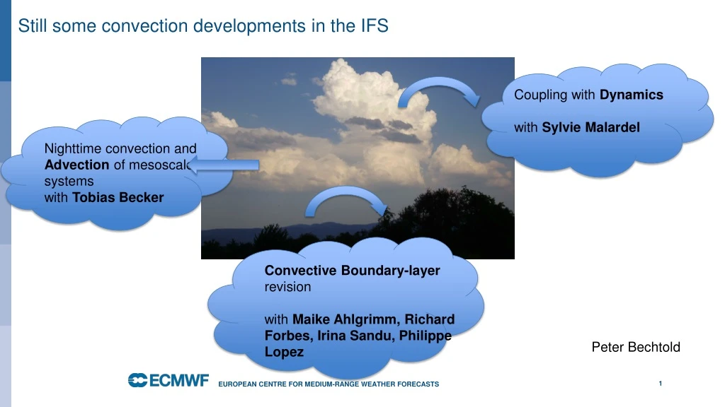
Still some convection developments in the IFS Coupling with Dynamics with Sylvie Malardel Nighttime convection and Advection of mesoscale systems with Tobias Becker Convective Boundary-layer revision with MaikeAhlgrimm, Richard Forbes, Irina Sandu, Philippe Lopez Peter Bechtold European Centre for Medium-Range Weather Forecasts
The TOA Swnet and the effect of revised convective mixed phase (average good but..) (shallow+congestus) • Cu too reflective • Sc not enough (lack of liq water) • Dry bias West Pacific DJF SST change Li et al. JGR 2013 European Centre for Medium-Range Weather Forecasts
qt frequency shallow [0-1] Revision of the convective cloudy boundary-layer • No iteration of vertical diffusion scheme, No statistical cloud scheme, • Same test parcel for convective boundary-layer height as in convection • Rewritten diffusion momentum solver • Shallow convection does moist transport, improved stability of shallow convection for Stratocumulus (mass fluxes) • Consistent coupling to cloud scheme through detrainment and subsidence terms • Revised and sequential cloud saturation adjustment (no double call of cloud scheme) • 6% faster IFS Kdiff Rad Kdiff Sc Kdiff Mdry MCu Use inversion strength –Pascal Marquet moist static energy European Centre for Medium-Range Weather Forecasts
The MAGICS ship transect Comparing Obs, LES and 3D IFS California Hawaii European Centre for Medium-Range Weather Forecasts
Clouds in coupled climate simulations European Centre for Medium-Range Weather Forecasts
Mesoscale convective systems, their propagation and the diurnal cycle Figure: Sequence of Meteosat 10 infrared and TRMM rainfall radar sequences over Sahel and reforecast for 8 Aug 2017 at 4 km with and without deep convection parametrization mm/3h European Centre for Medium-Range Weather Forecasts
August 2017 Ensemble representation SPP see Ollinaho et al. QJRMS 2017 Figure: Pdf of perturbed convection parameters and standard deviation (spred) of total precipitation during August from 15-member ensemble runs mm/3h European Centre for Medium-Range Weather Forecasts
Lightning and the diurnal cycle Figure: The lightning product has been developed by P. Lopez (MWR 2019) and uses the CAPE, frozen water content and cloud base height from the convection European Centre for Medium-Range Weather Forecasts
Direct convection-dynamics coupling via mass flux divergence European Centre for Medium-Range Weather Forecasts Malardel and Bechtold, QJRMS 2019
Direct convection-dynamics coupling: change in q-tendencies (K/day) Dynamics Convection K/day K/day Difference European Centre for Medium-Range Weather Forecasts
Direct convection-dynamics coupling: squall line on small Planet dx=2 km Convection permitting Param Param+coupling European Centre for Medium-Range Weather Forecasts
Precipitation verification against Synop observations: 4 km, 9 km August 2016 European Centre for Medium-Range Weather Forecasts
CAPE and CIN before and after precipitation Tobias Becker European Centre for Medium-Range Weather Forecasts
Precipitation and propagation European Centre for Medium-Range Weather Forecasts
Conclusions • Revision of convective PBL (3 years), hopefully operational post-Bologna 2020/2021 • Start working on TKE (Mete France, KNMI) to get more energetic constraint on diffusion coefficients • Physics-dynamics coupling difficult and likely less important for systematic convection (heating) errors • At 4 km neither convection permitting nor parametrized is ideal • Continue working on night-time underestimation of convection and advection • West Pacific dry bias in coupled mode European Centre for Medium-Range Weather Forecasts
Mesoscale convective systems, their propagation and the diurnal cycle Figure: Sequence of Meteosat 10 infrared and TRMM rainfall radar sequences over Sahel and reforecast for 8 Aug 2017 at 4 km with and without deep convection parametrization mm/3h European Centre for Medium-Range Weather Forecasts