Download
1 / 21
210 likes | 320 Views
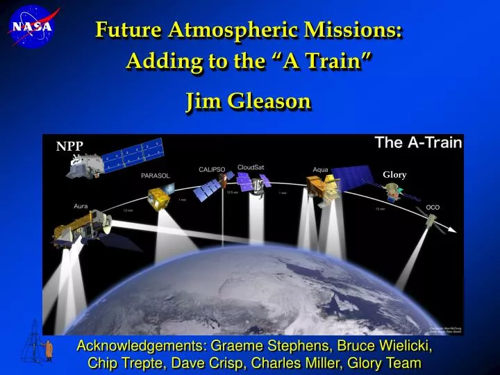
Glory. Future Atmospheric Missions: Adding to the “A Train” Jim Gleason. NPP. Acknowledgements: Graeme Stephens, Bruce Wielicki, Chip Trepte, Dave Crisp, Charles Miller, Glory Team. 1:38 PM. Aura. OMI - Cloud heights OMI & HIRLDS – Aerosols MLS& TES - H 2 O & temp profiles

E N D
Glory Future Atmospheric Missions:Adding to the “A Train”Jim Gleason NPP Acknowledgements: Graeme Stephens, Bruce Wielicki, Chip Trepte, Dave Crisp, Charles Miller, Glory Team
1:38 PM Aura OMI - Cloud heights OMI & HIRLDS – Aerosols MLS& TES - H2O & temp profiles MLS & HIRDLS – Cirrus clouds The Afternoon Constellation NPP VIIRS - Clouds & Aerosols CrIS/ATMS- Temperature and H2O Sounding OMPS - Ozone 1:30 PM 1:30 PM 1:15 PM Glory Cloudsat OCO CALIPSO Aqua PARASOL OCO - CO2 column CALIPSO- Aerosol and cloud heights Cloudsat - cloud droplets PARASOL - aerosol and cloud polarization OCO - CO2 MODIS/ CERES IR Properties of Clouds AIRS Temperature and H2O Sounding
NPP is not in a control box CALIPSO Control Box Aqua Cloudsat CALIPSO PARASOL Aura Cloudsat will “orbit”CALIPSO, both loosely following Aqua
CALIPSO(formerly Picasso-CENA) Cloud-Aerosol Lidar and Infrared Pathfinder Satellite Observation IIR 20 km 10 Laser WFC 0 Distance LITE measurements over convection • 2-wavelength (532 and 1064 nm) polarization-sensitive LIDAR that provides 30 m vertical resolution profiles of aerosols and clouds. • Imaging infrared radiometer (IIR) that provides calibrated infrared radiances at 8.7 µ, 10.5 µ and 12 µ. These wavelengths are optimized for combined IIR/lidar retrievals of cirrus particle size. • High-resolution wide field camera (WFC) that acquires high spatial resolution imagery for meteorological context (620 to 670 nm).
Cloudsat • 94 GHz Cloud Profiling Radar (CPR) • Nadir-viewing • 500 m vertical resolution • 1.2 km cross-track, 3.5 km along track • Sensitivity: -30 to -36 dBZ Data Products • Radar reflectivity • Visible and near-IR radiances • Cloud base and top heights • Optical depth • Atmospheric heating rates • Cloud water content • Cloud ice content • Cloud particle size • Precipitation Occurrence
NPOESS Preparatory Project: NPP • Sun - synchronous, polar • Altitude - 824 km nominal • Inclination - 98 degrees • Ascending node - 10:30 a.m. • Launched – April 2008 Instruments • Cross Track Infrared Sounder (CrIS) • Advanced Technology Microwave Sounder (ATMS) • Visible Infrared Imaging Spectrometer (VIIRS) • Ozone Mapping and Profiler Suite (OMPS)
Ozone Mapping Profiler Suite Status • Brass Board Main Electronics Box complete • Flight Unit #1 Assembly underway Description • Purpose: Monitors the total column and vertical profile of ozone • Predecessor Instruments: TOMS, SBUV, GOME, OSIRIS, SCIAMACHY • Approach: Nadir and limb push broom CCD spectrometers • Swath width: 2600 km Algorithm Status: Using TOMS/SBUV heritage approaches for Nadir Instruments Limb profile still in development using new space-based limb observation data
(Limb Profiler) (Nadir TC) OMPS Scanning Track
Orbiting Carbon Observatory - OCO OCO is an ESSP Mission LRD: 2008 Instruments- 3 Grating Spectrometers O2 - A Band at 0.76µ CO2 at 1.58, 2.06 µ Swath 10 pixels, 1x1.5 km CO2 Simulation Map • Make global, space-based observations of the column integrated CO2 • Provide independent data validation approaches to ensure high accuracy (1 ppm, 0.3%) • Combine satellite data with ground-based measurements to characterize CO2 sources and sinks on regional scales on monthly to interannual time scales
The Orbiting Carbon Observatory (OCO) OCO will acquire the space-based data needed to identify CO2 sources and sinks and quantify their variability over the seasonal cycle Approach: • Collect spatially resolved, high resolution spectroscopic observations of CO2 and O2 absorption in reflected sunlight • Use these data to resolve spatial and temporal variations in the column averaged CO2 dry air mole fraction,XCO2over the sunlit hemisphere • Employ independent calibration and validation approaches to produce XCO2 estimates with random errors and biases no larger than 1 - 2 ppm (0.3 - 0.5%) on regional scales at monthly intervals
CO2 2.06 m CO2 1.61m O2 A-band Clouds/Aerosols, Surface Pressure Column CO2 Clouds/Aerosols, H2O, Temperature Making Precise CO2 Measurements from Space • High resolution spectra of reflected sunlight in near IR CO2 and O2 bands are combined to retrieve the column average CO2 dry air mole fraction, XCO2 • 1.61 m CO2 bands – Column CO2 with maximum sensitivity near the surface • O2 A-band and 2.06 m CO2 band • Surface pressure, albedo, atmospheric temperature, water vapor, clouds, aerosols • Why high spectral resolution? • Enhances sensitivity, minimizes biases
Glint Spot Ground Track Local Nadir OCO Observing Strategy • Nadir Observations: tracks local nadir • + Small footprint (< 3 km2) isolates cloud-free scenes and reduces biases from spatial inhomogeneities over land • Low Signal/Noise over dark ocean • Glint Observations: views “glint” spot • + Improves Signal/Noise over oceans • More interference from clouds • Target Observations • Tracks a stationary surface calibration site to collect large numbers of soundings • Data acquisition schedule: • alternate between Nadir and Glint on 16-day intervals • Acquire ~1 Target observation each day
Calibration/Validation ProgramAssures Measurement Accuracy Calibration • Pre Launch • Instrument Subsystem • Observatory-level • On-Orbit • Routine (Solar, Limb, Dark, Lamp) • Special (Stellar, Solar Doppler) • Vicarious Validation • Laboratory spectroscopy • Spectral line databases for CO2, O2 • Ground-based in-situ measurements • NOAA ESRL Flask/Tower Network • Wofsy (Harvard), Ciais (CNRS Aerocarb) • Solar-looking FTS measurements of XCO2 • Measure same bands as flight instrument Routine Calibration WLEF Tower WLEF FTIR
Glory mission provides timely key data for climate change research The Glory Mission Objectives are to: • Quantify the role of aerosols as natural and anthropogenic agents of climate change by flying APS • Continue measuring the total solar irradiance to determine its direct and indirect effects on climate by flying TIM
Existing aerosol retrievals from space are inadequate Glory APS strategy: fully exploit the information content of the reflected sunlight Classification of passive remote sensing techniques by 1. Spectral range 2. Scattering geometry range 3. Number of Stokes parameters Hierarchy of existing/planned instruments: AVHRR MODIS, MISR, VIIRS Glory APS Glory APS will be a bridge to NPOESS era measurements. • The measurement approach developed for the Glory mission is to use • multi-angle multi-spectral polarimetric measurements because: • Polarization is a relative measurement that can be made extremely accurately. • Polarimetric measurements can be accurately and stably calibrated on orbit. • The variation of polarization with scattering angle and wavelength allows aerosol particle size, refractive index and shape to be determined. • Appropriate analysis tools are available.
Glory APS summary Type: Passive multi-angle photopolarimeter Fore-optic: Rotating polarization-compensated mirror assembly scanning along orbit-track +50.5° to –63° (fore-to-aft) from nadir Aft-optic: 6 bore-sighted optical assemblies, each with a Wollaston prism providing polarization separation, beamsplitters & bandpass filters producing spectral separation, and paired detectors sensing orthogonal polarizations Directionality: ~250 views of a scene Approx. dimensions:60 x 58 x 47 cm Mass/power/data rate:53 kg / 36 W / 120 kbps Spectral range: 412–2250 nm Measurement specifics:3 visible (412, 443, 555 nm), 3 near-IR (672, 865, 910 nm), and 3 short-wave IR (1378, 1610, 2250 nm) bands; three Stokes parameters (I, Q, and U) Ground resolution at nadir: 6 km SNR requirements:235 (channels 1 – 5, 8, and 9), 94 (channel 6), and 141 (channel 7) Polarization accuracy: 0.0015 at P = 0.2, 0.002 at P = 0.5 Repeat cycle: 16 days APS angular scanning APS spectral channels
Summary of the “A” Train • The Formation • Aqua (1:30 PM )and Aura (1:38 PM)) must maintain ground track on the WRS (±20 km) using frequent burns (once every 3 months) • Cloudsat and CALIPSO ~20 seconds (~140 km) behind Aqua within a control box 40 seconds wide. Near end of mission, CALIPSO drifts (left) across MODIS swath. • PARASOL is roughly lined up Aqua about 3 minutes behind • Aura is 15 minutes behind Aqua (crossing time is 1:38 PM) • OCO is 15 minutes ahead of Aqua (1:15) • NPP same crossing time, higher orbit • The Science • Unprecedented cloud science • Unprecedented climate/aerosol/chemistry science • Correlative measurements • Challenges • Variety of vertical and horizontal resolutions which will be challenging to match • Community is not used to using multi-instrument systems
New Mission Planning Air Quality Mission Workshop Boulder, CO February 2006 Satellite observations as crucial for the future of AQ management: • Air quality characterization for retrospective assessments and forecasting to support air program management and public health advisories; 2. Quantification of emissions of ozone and aerosol precursors; 3. Long-range transport of pollutants extending from regional to global scales; 4. Large puff releases from environmental disasters. http://www.acd.ucar.edu/Events/Meetings/Air_Quality_Remote_Sensing/index.shtml
Air Quality Mission WorkshopReport to National Research Council Decadal Survey Measurement Requirements: Species measured; Tropospheric ozone, CO, NO2, HCHO, SO2, and aerosols Horizontal resolution and coverage; better than 10 km (preferably 2-5 km), coverage must be at least on a continental scale for observation of regional pollution episodes, and must further extend on a global scale for observation of intercontinental transport and large puff releases. Temporal resolution and coverage: Hourly resolution or better Enables characterization of (1) the synoptic-scale development of pollution episodes, (2) the diurnal variation of emissions, (3) the state of atmospheric composition for purposes of inverse modeling and data assimilation (forecasting), and (4) large puff releases. http://www.acd.ucar.edu/Events/Meetings/Air_Quality_Remote_Sensing/index.shtml
Air Quality Mission WorkshopReport to National Research Council Decadal Survey Measurement Requirements: Vertical resolution: The ability to observe the boundary layer from space is a major priority for air quality applications. For trace gases, multispectral methods involving a combination of nadir-sounding UV/Vis, near and thermal IR, and limb microwave can be used to infer boundary layer information on ozone, CO and others, as well as providing some vertically-resolved measurements for the middle and upper troposphere. Vertical resolution in the free troposphere is important for observing long-range transport, as this transport often involves layers of ~1 km thickness that may retain their integrity over intercontinental scales. Orbital Requirements: Considered LEO, MEO, GEO, and L-1 Orbits have different advantages and disadvantages for air quality observations. There are important trade-offs among quantitative (and achievable) requirements on • horizontal resolution and coverage, • temporal resolution, • vertical resolution. http://www.acd.ucar.edu/Events/Meetings/Air_Quality_Remote_Sensing/index.shtml
Air Quality Mission WorkshopReport to National Research Council Decadal Survey Workshop participants reached a consensus that multi-spectral sentinel missions (GEO or Lagrangian (L-1) orbit) that have high spatial and temporal resolution, and provide some species concentrations within the boundary layer, would be most beneficial to the AQ community. At the present time, GEO meets this measurement capability with the least amount of risk The greatest societal benefit from a U.S. perspective would be derived from placing such a satellite in an orbit capable of observing North America. The NOAA GOES-R operational suite of measurements from GEO will have some AQ relevant capability for ozone, carbon monoxide and aerosol. New generation of dedicated AQ satellite missions that will also be part of an integrated observing system including air monitoring networks, in situ research campaigns, and 3-D chemical transport models. http://www.acd.ucar.edu/Events/Meetings/Air_Quality_Remote_Sensing/index.shtml