Download
1 / 87
880 likes | 1.08k Views
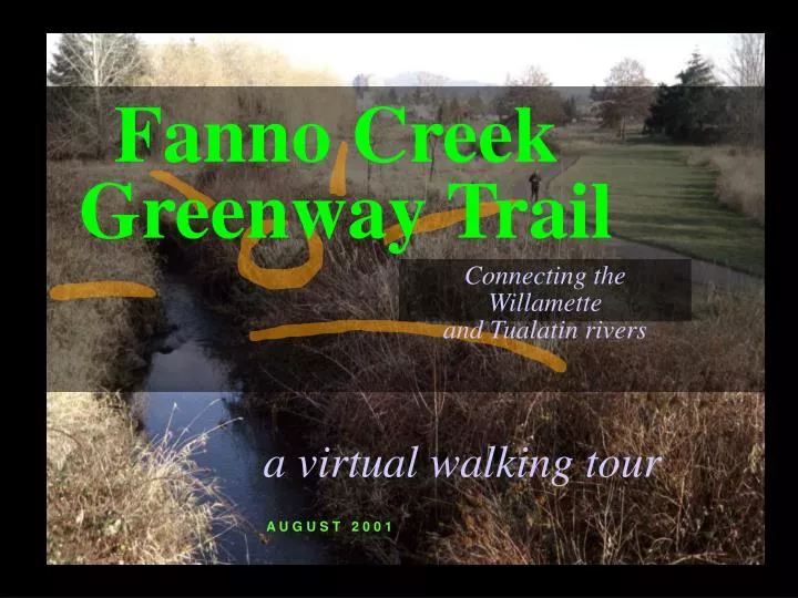
Fanno Creek Greenway Trail. Connecting the Willamette and Tualatin rivers. a virtual walking tour. A U G U S T 2 0 0 1. Fanno Creek Greenway Trail. The Fanno Creek Greenway Trail is an important link in the regional trails and greenways network.

E N D
Fanno Creek Greenway Trail Connecting the Willamette and Tualatin rivers a virtual walking tour A U G U S T 2 0 0 1
Fanno Creek Greenway Trail The Fanno Creek Greenway Trail is an important link in the regional trails and greenways network.
A major tributary of the Tualatin River, Fanno Creek meanders approximately 15 miles through Portland, Beaverton and Tigard, emptying into the Tualatin at Durham. This urban watershed encompasses about 32 square miles with numerous tributaries, wetlands and springs, that provide critical fish and wildlife habitat for more than 140 species of birds, mammals and other wildlife.
The Fanno Creek Greenway Trail is a ribbon of water, vegetation and trail gracefully weaving through the city, taking visitors from the shores of the Willamette River in southwest Portland to the confluence of Fanno Creek and the scenic Tualatin River.
1 1 Willamette Park to Hillsdale (2 miles) 2 Hillsdale to Garden Home (4 miles) 3 Garden Home to Denney Road (2.5 miles) 4 Denney Road to Scholls Ferry Rd (1.5 miles) 5 Scholls Ferry Rd to Hall Blvd (2.5 miles) 6 Hall Blvd to Durham City Park (2.5 miles) This tour covers over 15 miles and is divided into 6 segments
1Willamette Park to Hillsdale A. Pedestrian Route B. Bike Route P o r t l a n d
Willamette River Greenway Trail in Willamette Park (looking north)
On SW Nebraska (at Macadam) looking east to Willamette River
trail entrance Looking west on SW Iowa (at SW Virginia) towards George Himes Park in the Corbett Terwilliger / Lair Hill Neighborhood
Terwilliger path Heading to Terwilliger path from George Himes Park at SW Capitol Highway and SW Terwilliger Boulevard
Hillsdale Town Center heading west on SW Beaverton Hillsdale Highway to Red Electric Route
At Stephens Creek Natural Area heading south on Bertha Boulevard
Leaving Willamette Park heading south on Miles Court to Butterfly Park
2 Hillsdale to Garden Home A. Bike/Ped (Red Electric) Route B. Pedestrian Route C. Bike Route Portland to unincorporated Washington County
Heading west on SW Capitol Hwy, past the Red Electric Café (formerly Bertha Station on the Red Electric line)
Heading west on Red Electric right-of-way near SW Fairvale Drive
Intersection of SW Oleson Road and Vermont Street (heading west on Vermont to Oregon Episcopal School)
3Garden Home toDenney Trailhead unincorporated Washington County to Beaverton
Bridge over Fanno Creek heading west to Vista Brook Park
Oregon Electric Trail footpath through park View from Vista Brook Park
Trail on Oregon Electric right-of-way crossing SW 90th Ave
Heading west with paved trail ending ahead at SW 92nd Avenue & Allen Boulevard
Heading west, crossing SW Allen Boulevard at Scholls Ferry Road
Parking lot over trail at Beaverton Maintenance Operations Center
Landscape enhancement between Greenwood Inn and 217 view from potential trail alignment
Hwy 217 Heading south along SW 105th Ave (south of Greenwood Inn) heading towards SW Denney Boulevard
new trailhead Heading south, crossing SW Denney Road with view to Trailhead
4Denney Road toScholls Ferry Road Beaverton
Trailhead SW Denney Road to Scholls Ferry Road (1.5 mi)