
TopFusion
TopFusion. Download. http://www.topofusion.com/registered.php Registration Name: Office of Surface Mining WR Case sensitive Registration Code: 1471 Run from window Execute file Launch TopoFusion (enter registration again) Remain at initial screen

TopFusion
E N D
Presentation Transcript
Download • http://www.topofusion.com/registered.php • Registration Name: Office of Surface Mining WR • Case sensitive • Registration Code: 1471 • Run from window • Execute file • Launch TopoFusion (enter registration again) • Remain at initial screen • At your home office IT staff may need to install
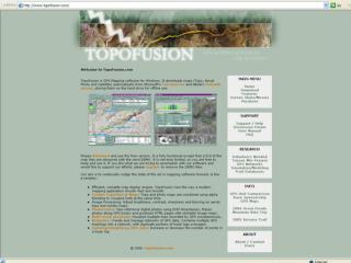
Tileset Selector Toolbar Fileview Selector Active File List
How does it work? • Maps (Instructor leads on screen tour) • Topographic • Aerials (T) • Color (C) • Map scale • 3D • Coordinates on menu bar
How does it work? • Options • Preferences • 3-D settings • Pan Map • Zoom Box • Select point • Mark Point • Draw Track • Toggle view waypoints and tracks
How does it work? • Find your house • Topo • Aerial • 3D • From Aerial Mark Waypoint at your house • Save in file: C:\GPS\New.gpx • Use Mark Waypoint, change coordinates to: N40 25 29.4 W80 02 17.5 • Name Point Parkway Center • Save in file: New.gpx
How does it work? • Measure distance from your house to parkway center using Draw Track • Measure the width of buildings • Explore on you own – 10 minutes • Find you favorite place • File view selector • Active file list
How does it work? • Open C:\GPS\Parkway.gpx • Center on map • Zoom in and out • Profile and Playback tool demo • Print Screen or use export function • Copy to word document • Save as shape files for ESRI products
Topo and Aerial Info? • To get map dates: http://terraserver-usa.com/ • To get USGS Quadrangles: http://www.topozone.com/viewmaps.asp
Examples • Stationary point • Senex