Download
1 / 18
180 likes | 347 Views
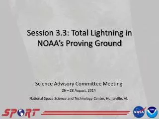
Session 3.3: Total Lightning in NOAA’s Proving Ground. Science Advisory Committee Meeting 26 – 28 August, 2014. National Space Science and Technology Center, Huntsville, AL. 1. Overview. What is total lightning? History and relevance with SPoRT How is this applied to the Proving Ground?

E N D
Session 3.3: Total Lightning in NOAA’s Proving Ground Science Advisory Committee Meeting 26 – 28 August, 2014 National Space Science and Technology Center, Huntsville, AL
1 Overview • What is total lightning? • History and relevance with SPoRT • How is this applied to the Proving Ground? • Results and Successes • Future Work
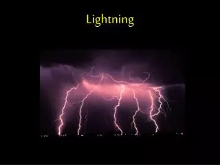
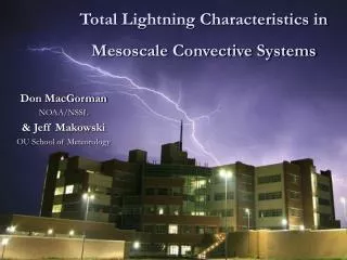
2 Total Lightning in a Flash 12 Flashes • Total lightning • Cloud-to-ground plus intra-cloud flashes • More observations that cloud-to-ground alone • Rapid increases = Lightning Jumps • Precursors to severe weather • Much more though • Lightning safety • Aviation applications 1442 UTC Total Lightning 3.4° Reflectivity, ~20 kft 64 Flashes 1450 UTC 1451 UTC
3 History and Relevance • Original core SPoRT activity • 2003 with NASA’s North Alabama Lightning Mapping Array (NALMA) • Expanded to NASA’s KSC and Washington D.C. networks • Relevance to SPoRT • Forecasters: Improve severe weather decision support • NASA’s NALMA NASA directly addresses this issue • Collaboration highly active 11 years later • Effort has resulted in training, assessments, and new products Lightning jump example submitted by WFO Morristown, TN
4 Ties to the Proving Ground • SPoRT is a leader in operational use of total lightning • Proving Ground preparing forecasters for the Geostationary Lightning Mapper (GLM) • LMAs demonstrate GLM well • PG could not use AWG proxy • Not real-time, only one network • SPoRT developed the pseudo-GLM (PGLM) product in 2009 • Synergistic with SPoRT core activities • De facto demonstration product for Proving Ground Sample PGLM imagery in AWIPS II Sample PGLM imagery in NAWIPS for National Centers
5 What is the Pseudo-GLM? • Convert LMA data to flashes • Assign to GLM resolution grid (8 km) • Sum all flashes in grid box • Drawbacks • Not an exact proxy for GLM • GLM optical, PGLM uses VHF • Actual GLM display may differ • Advantages • Real-time, any LMA • Excellent training tool • Integrate lessons learned y x
6 Preparing the Forecaster Community Collaborative LMA • Expanding partnerships • More LMAs • Strong support from Visiting Scientist Proposals Operational end user Sterling Mt. Holly Wakefield State College Boulder Cheyenne Denver CWSU Aviation Weather Center Storm Prediction Center Albuquerque WFO & CWSU Huntsville Morristown Nashville Houston WFO & CWSU SMG Melbourne
7 Preparing the Forecaster Community • End user specific training • Integrate with formal Proving Ground activities … • Hazardous Weather Testbed, Aviation Weather Testbed, Operations Proving Ground • Active coordination with Satellite Liaisons • Proving Ground support for National Centers and OCONUS • … but also SPoRT specific activities National Center PGLM module Hazardous Weather Testbed PGLM module
8 Hazardous Weather Testbed • SPoRT activity since 2009 • Provide data, products, training • Responses have led to: • New color curves • Max density product • Moving trace tool with MDL • Forecasters appreciate: • Rapid update • Ability to “triage” storms • Storm dynamics insight Forecaster quote: “The strongest updraft this evening showed marked ramp up of flashes to 40 just as the storms 50 dBZ core reached 26.25. Although the storm didn’t reach severe criteria, it was beneficial that the Flash Extent Density updates in 1 minute intervals, which lets the warning forecaster monitor for rapid updraft development between radar volume scans. This storm resulted in a report of dime size hail.”
9 National Centers • SPoRT first to reach out to National Centers to prepare for GLM • 2012 VSPs to Aviation Weather Center and Storm Prediction Center • Needed different display • PGLM mosaic in NAWIPS • All available LMAs in one file • Interactive process • Altered color curve • Changing file format Effective range rings “Quick look” network status Sample PGLM mosaic image in NAWIPS.
10 National Center Example • PGLM showed spatial extent • Lightning well behind line • Could impact how AWC issues Convective SIGMETS (i.e., expanded coverage) • Aviation Weather Testbed 2013 • PGLM observations versus radar and NLDN • Noted NLDN in the main line Strong convection with trailing stratiform region Note active lightning behind convective line NLDN only in main core NAWIPS radar reflectivity PGLM Mosaic over Central Florida
11 2014 SPoRT Assessment: Results • Numerous new partners • First effort to bring lightning to CWSUs and operational use of new networks • Formal report pending, based on 40 surveys • Key Results: Strong support for data, confidence in use from training, and diverse applications • Take away: GLM has large potential impact in operations once launched Forecaster Confidence Impact of Total Lightning Reported Activities
12 SPoRT 2014 Assessment: Examples • Cheyenne Frontier Days Rodeo • Largest outdoor rodeo in world • 10 days, 200+ thousand visitors total • “The WFO was providing weather support to the Laramie County Emergency Manager on the evening of June 20th. Convection developed south of Cheyenne, moving north producing some total lightning. The activity remained greater than 15 miles from Frontier Park and [the data] proved extremely useful in enhancing situational awareness and forecast confidence throughout the event. • CWSU Denver • Greatest use monitoring Terminal Radar Approach Control (TRACON) routes • “… useful to monitor storms to brief the Traffic Management Unit on gate [air route] open / closure decisions.” • “Total lightning source density enabled [ZDV to issue] a warning to the Traffic Management Coordinator that a hole southeast of Denver in a thunderstorm line was closing, and would impact [aircraft] arrivals.”
13 Additional Successes • SPoRT continues to expand operational use of total lightning • Numerous collaborations for data and WFO participation • “Non-traditional” partners: National Centers, CWSUs, aviation • Community coming to SPoRT for aid: Alaska Region, possible ENTLN • Provided subject support to upcoming COMET module • Diversified operational use • Recent assessment highlighted numerous uses and can apply to GLM! • More than lightning jumps and severe weather! • Lightning safety, aviation, impact decision support, flood warnings • Publications • Total lightning in Moore tornado – Published • 3 more pending (The PGLM, Long flashes, AWC applications)
14 Future Activities / Opportunities • Continue training support • Report assessment results • Decision support, such as AWIPS II • Post GLM launch applications • Integration with ground networks • Evaluation and verification • Downscale GLM data with ground observations • Automated safety algorithms • International opportunities • Support NASA’s SERVIR group • Support Meteosat’s GLM work with operational expertise PGLM in AWIPS II (top) with tracking tool (top inset) with the corresponding radar reflectivity (bottom) for the 20 May 2013 Moore, Oklahoma tornado at 1950 UTC.
15 Questions? (Above) Total lightning in AWIPS II at WFO Melbourne showing a 40 km long flash. (Above) PGLM mosaic in NAWIPS for National Centers. (Right) PGLM and radar in AWIPS II for the Hazardous Weather Testbed.
16 Questions • Text should be 24-point Calibri with dot bullets • Sub-bullets should be 18-point Calibri with a dash bullets • Avoid use of secondary sub-bullets • Put in as many pictures as you like and wrap text around pictures as needed HEY!! Lightning here too!!! Lightning jump detection PGLM Flash Initiation Density PGLM Flash Extent Density Forecaster Quote: “… the flash extent density, along with the lightning jump algorithm showed that the storm moving east of Denver was again intensifying.” GLM domain for GOES-East and –West showing the total lightning climotology from the OTD and LIS (1995-2005)
17 National Center Feedback • Aviation Weather Testbed • First effort to bring total lightning to National Centers • Show quotes • Show Ed’s FL example, and 2013 Houston flight track example