Creating Dry Earth Models for Soil Moisture Estimation in Arid Regions
This paper introduces a novel methodology using DRY Earth Models (DREAMS) to estimate soil moisture in arid terrains from satellite radar altimetry data, enabling remote measurement in regions with limited ground truth. A detailed overview of the SMALT processing scheme is provided, along with comparison/validation with other remote sensing techniques. The freely available SMALT products offer valuable insights into arid/semi-arid soil moisture levels. Key steps, like model masking and production chain development, are outlined, showcasing the potential of this approach. 8

Creating Dry Earth Models for Soil Moisture Estimation in Arid Regions
E N D
Presentation Transcript
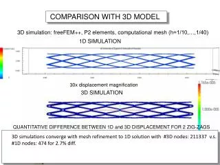
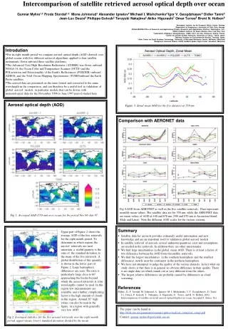
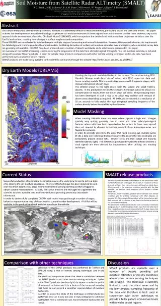
comparison with those produced Abstract Soil surface moisture is a key scientific parameter; however, it is extremely difficult to measure remotely, particularly in arid and semi-arid terrain. This paper outlines the development of a novel methodology to generate soil moisture estimates in these regions from multi-mission satellite radar altimetry. Key to this approach is the development of detailed DRy Earth ModelS (DREAMS), which encapsulate the detailed and intricate surface brightness variations over the Earth’s land surface, resulting from changes in surface roughness and composition. These DREAMS are complicated to build and require multiple stages of processing and manual intervention. However, this approach obviates the requirement for detailed ground truth to populate theoretical models, facilitating derivation of surface soil moisture estimates over arid regions, where detailed survey data are generally not available. DREAMS have been produced over a number of deserts worldwide and a selection are presented in this paper. An overview of the SMALT processing scheme, covering the progression of the data from altimeter sigma0 through to final soil moisture estimate, is included along with example SMALT products. In order to validate these products comparisons with other remote sensing techniques and in-situ data have been performed over a number of desert regions. SMALT products are made freely available to the scientific community through the website http://tethys.eaprs.cse.dmu.ac.uk/SMALT Dry Earth Models (DREAMS) Creating the dry earth models is the key to this process. This requires fusing ERS1 Geodetic Mission recalculated sigma0 values with ERS2 repeat arc data and hence creating models. This is a multi-stage process with 6 separate stages, with manual intervention at each stage. The DREAM shown to the right covers both the Gibson and Great Victoria deserts. In the production version these deserts have been subset to ensure no contamination of results from non-desert areas can occur. The processing chain has been developed in such a way as to allow easy addition and removal of desert areas depending as required. All DREAMS are created at a resolution of 10 arc seconds to fully exploit the high alongtrack sampling frequency of the surface directly below the satellite by the altimeter. Soil Moisture from Satellite Radar ALTimetry (SMALT)R G. Smith1, M.K. Salloway1, P. A.M. Berry2, M Dowson3, W. Wagner4, A Egibo5, J. Benveniste61: Earth and Planetary Remote Sensing Laboratory, De Montfort University, Leicester, LE1 9BH email:pamb@dmu.ac.uk2: School of Civil Engineering and Geosciences, Cassie Building, Newcastle University, NE17RU3: Arnesbury Ltd, The Granary, St Peters Road, Arnesbury, Leicestershire, UK5:. STARLAB, Carrer de Teodor Roviralta, 45 08022 Barcelona, Spain6: European Space Agency, Earth Observation Applications Department, ESRIN, Via Galileo Galilei, I-00044, Frascati (RM), Italy Model Masking When creating DREAMS there are areas where sigma0 is high and changes spatially very quickly, generally due to salars and other paleo-hydrological features, where salts have been deposited on the surface. In these cases sigma0 does not respond to changes in moisture content, these anomalous areas are flagged for exclusion. In order to correctly determine the areas that need masking out, multiple cycles of ERS-2 data over individual tracks are analysed to ensure that any anomalies are consistently present (below left). Smaller areas are then subset and features identified (below right). The differences produced between the DREAM and ERS-2 track sigma0 are then checked for improvement after utilising this masking technique. SMALT release products Current Status Successful production of soil moisture estimates requires the underlying terrain to get to a state of as close to 0% soil moisture as possible. Therefore this technique has been designed to work over the driest desert areas, areas where other remote sensing techniques often struggle to obtain useable measurements. As such, the SMALT products are envisaged to supplement the scientific datasets available over arid/semi-arid areas providing previously unavailable information. In order to derive a fully completed DREAM each model must go through a number of stages, below is a representative map of desert models currently under development. A full list will be available in the product handbook available soon from the website. The SMALT products will be freely released at two resolutions over a number of arid/semi-arid region. The maximum resolution of these products will vary from region to region, although as stated above 18 arc seconds is the maximum resolution possible with the data available. An example ERS-2 timeseries of this product is shown below left. The second, lower resolution, product will be released 6 arc minute resolution grid to facilitate comparison with other datasets, an example ERS-2 timeseries of this product will be shown below right. Both products will be released as text files in the format as shown in the example below centre. The altimeter is able to derive detailed nadir soil moisture estimates alongtrack but is unable to obtain results away from the orbit track. This, coupled with the repeat measurement of 35-days means that these products are seen as complementary to other remote sensing datasets such as SMOS and scatterometry. # SMALT_ENVK_G_14_20_26549S_137050E.SMA -26.549999S 137.0500E # ENVK V1.00 Res 0.100000 01 07 2013 10:51 GRID # DD| MM| YYYY| SMC| Cycle| Latitude| Longitude| Orbit| Count| ASD| TSD| SZ0| 17 10 2002 2.22 010 -26.5500 137.0500 3291 011 003.414006 037.554066 015.628181 00:34:58 30 01 2003 4.34 013 -26.5500 137.0500 4794 004 004.751484 019.005938 016.912498 00:34:56 06 03 2003 2.89 014 -26.5500 137.0500 5295 009 003.918981 035.270828 016.108888 00:34:55 10 04 2003 3.52 015 -26.5500 137.0500 5796 006 004.315722 025.894329 016.500000 00:34:58 15 05 2003 4.93 016 -26.5500 137.0500 6297 015 005.024072 075.361076 017.288000 00:34:54 02 10 2003 4.98 020 -26.5500 137.0500 8301 014 005.045231 070.633240 017.315714 00:35:05 06 11 2003 2.81 021 -26.5500 137.0500 8802 007 003.869149 027.084042 016.054285 00:35:01 11 12 2003 2.54 022 -26.5500 137.0500 9303 010 003.672083 036.720833 015.875000 00:35:04 15 01 2004 1.94 023 -26.5500 137.0500 9804 009 003.157739 028.419647 015.351112 00:35:03 19 02 2004 2.81 024 -26.5500 137.0500 10305 008 003.867440 030.939522 016.062500 00:35:02 29 04 2004 4.04 026 -26.5500 137.0500 11307 004 004.604992 018.419970 016.764999 00:35:02 08 07 2004 3.49 028 -26.5500 137.0500 12309 010 004.303134 043.031342 016.500000 00:35:07 12 08 2004 3.25 029 -26.5500 137.0500 12810 011 004.156662 045.723274 016.373635 00:35:07 16 09 2004 3.19 030 -26.5500 137.0500 13311 007 004.115657 028.809601 016.300001 00:35:04 25 11 2004 3.17 032 -26.5500 137.0500 14313 005 004.102679 020.513395 016.267999 00:35:05 Comparison with other techniques Discussion Validation of the SMALT products was performed by TuWien and STARLAB using a host of remote sensing techniques and in-situ data. The results of comparisons show that there is correlation between the SMALT products and other remote sensing techniques. Spikes in the SMALT products (see box right) do appear to relate to period of increased moisture and it is a factor of the temporal sampling that these do not present a smoother representation of moisture fluctuation. In order to assess the limits of the technique a limited study was performed over an in-situ test site in Italy compared to altimeter backscatter, here a correlation was found between backscatter and rainfall. SMALT products are available over a number of deserts providing soil moisture estimates in very dry conditions where other remote sensing techniques can struggle. The technique is currently limited to only the driest areas and by the low temporal sampling frequency of the data and therefore is best used in conjunction with other techniques to provide a fuller picture of moisture levels within wider desert regions.