Download
1 / 1
10 likes | 154 Views
NOAA CoastWatch/OceanWatch Ocean Color Activities: Contributions to Ocean Color Radiometry-Virtual Constellation. S. Ramachandran 2 , K. Hughes 1 (PRINCIPAL GOVERNMENT INVESTIGATOR) , Y.S. Kim 3 , M. Wang 1 1 NOAA/NESDIS/STAR, 2 SP-Systems Inc, 3 DELL/Perot Systems Government Services.

E N D
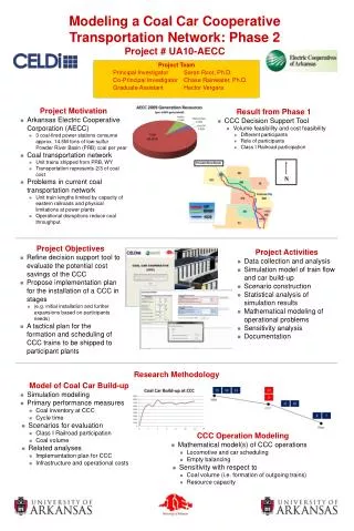
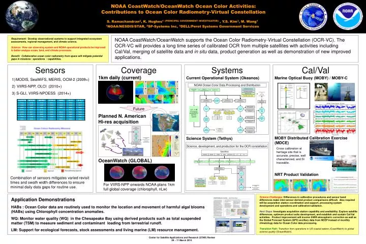
NOAA CoastWatch/OceanWatch Ocean Color Activities:Contributions to Ocean Color Radiometry-Virtual Constellation S. Ramachandran2, K. Hughes1(PRINCIPAL GOVERNMENT INVESTIGATOR) , Y.S. Kim3, M. Wang1 1NOAA/NESDIS/STAR, 2SP-Systems Inc, 3DELL/Perot Systems Government Services GCOM C-1 OCM2 C-1 NPP C-2 MODIS MERIS LSU Wallops Island CDA (WCDA) Miami Prince Albert, Canada (PAC) Gatineau, Canada (GNC) OSU R/V KA IMIKAI-O-KANALOA MET Ozone Sensor CAL Sensor Attribs Atm Corr MET Ozone Sensor CAL Sensor Attribs Atm Corr Satellites Software process Hardware system Climatology Modeled Near Real Time (NCEP GFS) Static Data Source Ancillary input data Approximate ground cover when Satellite altitude at; 800 Km 500 Km Tethys Developmental System L1 - L2 (L2gen) L2CWHDF (CW HDF Converter) Row data STAR Restricted Science Community L3MAP (CW Regions) Washington D.C STAR Firewall System Row data L1 data Row data Requirement: Develop observational systems to support integrated ecosystem assessments, regional management, and climate science. Science: How can observing system and NOAA operational products be improved to better analyze ocean, land, and climate processes. Benefit: Collaborative ocean color radiometry from space will mitigate potential gaps in missions / operations / capabilities. NOAA CoastWatch/OceanWatch supports the Ocean Color Radiometry-Virtual Constellation (OCR-VC). The OCR-VC will provides a long time series of calibrated OCR from multiple satellites with activities including Cal/Val, merging of satellite data and in situ data, product generation as well as demonstration of new improved applications. Cal/Val Sensors Coverage Systems 1km daily (current) Current Operational System (Okeanos) Marine Optical Buoy (MOBY) / MOBY-C • MODIS, SeaWiFS, MERIS, OCM-2 (2009+) • VIIRS-NPP, OLCI (2010+) • 3) S-GLI, VIIRS-NPOESS (2014+) NOAA Ocean Color Data Processing and Distribution Software process NASA EDOS System MERIS L2 (Reduced Resolution) SeaWIFS L1A Hardware system User Community Data Source Ancillary input data Developed Algorithm Parallel Test System (Okeanos) Operational System (Okeanos) Development System (Tethys) CoastWatch Web Server Archive (CLASS) FTP (Okeanos) Future L1 - L2 (L2gen) L1 - L2 (L2gen) L0 – L1B Processing NOAA/ESPC*/ NRTPE** System Browser CGI/ httpd Distribution server (Okeanos) Planned N. American Hi-res acquisition MySQL/ PostgreSQL DB Archive (CLASS) FTP (Okeanos) Climatology Modeled Near Real Time (NCEP GFS) Static L2CWHDF (CW HDF Converter) L2CWHDF (CW HDF Converter) Distribution server (Okeanos) FTP (Okeanos) L3MAP (CW Regions) L3MAP (CW Regions) STAR Restricted Science Community Distribution Server (Okeanos) MOBY Distributed Calibration Exercise (MDCE) Science System (Tethys) Science, development, and production for the OCR constellation Cross calibration at heritage site that is accurate, precise, well characterized, and SI traceable. Satellites OceanWatch (GLOBAL) Tethys Developmental System Washington D.C STAR Firewall System NRT Product Validation L1 - L2 (L2gen) Combination of sensors mitigates varied revisit times and swath width differences to ensure minimal daily data gaps for routine use. L2CWHDF (CW HDF Converter) For VIIRS-NPP onwards NOAA plans 1km full global coverage (chlorophyll, nLw) L3MAP (CW Regions) STAR Restricted Science Community6 Science Challenges:Differences in calibration procedures and sensor band differences make inter-sensor derived product comparisons difficult. Also required will be acquisition station coordination and support, processing system development and operations and calibration/validation. Next Steps: Investigate acquisition station capability and availability; Explore satellite differences, optimum product suite development, and establish and sustain Cal/Val activities. Product improvement will involve SWIR atmospheric correction as well as the Global Forecast System (GFS) ancillary data from NCEP instead of monthly climatology data for Ocean Color data processing. Transition Path: Transition from operations in US coastal waters (CoastWatch) to global science quality (OceanWatch). Application Demonstrations HABs : Ocean Color data are routinely used to monitor the location and movement of harmful algal blooms (HABs) using Chlorophyll concentration anomalies. WQ: Monitor water quality (WQ) in the Chesapeake Bay using derived products such as total suspended matter (TSM) to measure sediment and contaminant loading from terrestrial runoff. LM: Support for ecological forecasts, stock assessments and living marine (LM) resource management.