Download
1 / 69
690 likes | 793 Views
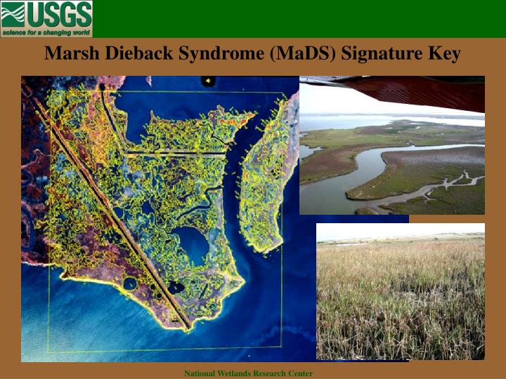
Marsh Dieback Syndrome (MaDS) Signature Key. National Wetlands Research Center. Marsh Dieback Syndrome (MaDS) Signature Key

E N D
Marsh Dieback Syndrome (MaDS) Signature Key National Wetlands Research Center
Marsh Dieback Syndrome (MaDS) Signature Key The objective of this signature key is to provide a consistent method for photointerpreters to delineate important features of healthy and affected marsh. This key will assist the user in understanding marsh classification using high-altitude color infrared photography as applied to the Marsh Dieback Syndrome. The process of developing a key iterates between field observations and laboratory analysis of the photography. Ground level field observations were carried-out primarily during the winter of 2001 with additional observations made at other times. Ongoing oblique, low-altitude monthly aerial observations have been conducted continuously since the summer of 2000. Whenever possible, the photos in this signature key refer to the same dates and locations in order to provide consistency across the scale of photography. National Wetlands Research Center
Marsh Dieback Syndrome (MaDS) Signature Key Impacted by Brown Marsh: Non-impacted Areas: Wetland Upland IEM US UB BM2 OW USBM UR AB USDM USS USS1 USS3 USS4 EM IUS UF1 UF3 UF4 UF SS SS1 SS3 SS4 SSg IOW UU FO FO1 FO3 FO4 IAB RS Modifiers: x s h o k BACK TO INTRODUCTION National Wetlands Research Center
Non-Impacted BACK National Wetlands Research Center
Impacted BACK National Wetlands Research Center
Classification Modifiers BACK National Wetlands Research Center
EM Emergent Marsh EM example (Aerial Photography) EM example (Oblique Photo) EM example (Ground Photo) BACK National Wetlands Research Center
EM_CIR BACK
EM_OBL BACK
EM_GRD BACK
SS Scrub Shrub SS1 example (Aerial Photography) SS1 example (Oblique Photo) SSg example (Aerial Photography) SSg example (Oblique Photo) SSg example (Ground Photo) BACK National Wetlands Research Center
SS1_CIR BACK
SS1_OBL BACK
SSg_CIR BACK
SSg_OBL BACK
SSg_GRD BACK
FO Forest FO1 example (Aerial Photography) FO1 example (Oblique Photo) FO1 example (Ground Photo) BACK National Wetlands Research Center
FO1_CIR BACK
FO1_OBL BACK
FO1_GRD BACK
AB Aquatic Bed BACK National Wetlands Research Center
OW Open Water OW example (Oblique Photo) OW example (Ground Photo) OWx example (Oblique Photo) BACK National Wetlands Research Center
OW_OBL BACK
OW_GRD BACK
OWx_OBL BACK
US Unconsolidated Shore US example (Oblique Photo) US example (Ground Photo) BACK National Wetlands Research Center
US_OBL BACK
US_GRD BACK
RS Rocky Shore RSk example (Ground Photo) BACK National Wetlands Research Center
RSk_GRD BACK
USS Upland Scrub Shrub USS1 example (Ground Photo) BACK National Wetlands Research Center
USS1_GRD BACK
UF Upland Forest UF1 example (Aerial Photography) UF1 example (Oblique Photo) UF1 example (Ground Photo) BACK National Wetlands Research Center
UF1_CIR BACK
UF1_OBL BACK
UF1_GRD BACK
UR Upland Range UR example (Aerial Photography) UR example (Ground Photo) BACK National Wetlands Research Center
UR_CIR BACK
UR_GRD BACK
UB Upland Barren UB example (Aerial Photography) UB example (Oblique Photo) BACK National Wetlands Research Center
UB_CIR BACK
UB_OBL BACK
UU Upland Urban UU example (Aerial Photography) UU example (Ground Photo) UUo example (Aerial Photography) BACK National Wetlands Research Center
UU_CIR BACK
UU_GRD BACK
UUo_CIR BACK
IEM Slightly impacted emergent marsh vegetation. IEM example (Aerial Photography) IEM example (Oblique Photo) IEM example (Ground Photo) BACK National Wetlands Research Center
IEM_CIR BACK
IEM_OBL BACK
IEM_GRD BACK