Download
1 / 1
10 likes | 619 Views
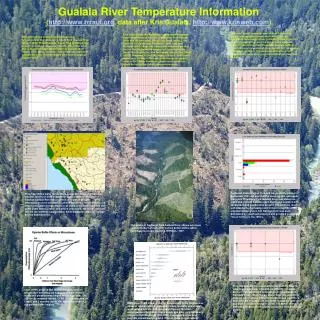
Gualala River Temperature Information ( http://www.rrraul.org , data after Kris Gualala, http://www.krisweb.com ).

E N D
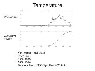
Gualala River Temperature Information (http://www.rrraul.org, data after Kris Gualala, http://www.krisweb.com) This chart shows seasonal maximum of the floating weekly average water temperature (MWAT) of the Wheatfield Fork Gualala River, including Fuller Creek (fc). The data suggest that only the Fuller Creek statiould suppn (fc606) and a small Wheatfield tributary (wf228) coort rearing of coho salmon juveniles (62.30 F according to Welsh et al., 2001). The mainstem Wheatfield Fork temperatures are acutely stressful or lethal for steelhead as well. This chart shows the maximum floating weekly average water temperature at stations in the North Fork Gualala River and its tributaries. While Doty Creek (doty), Little North Fork Gualala (lnf), Robinson Creek (rob) and McGann Gulch (mcg) may have water temperatures that are not limiting salmonid production, most mainstem North Fork Gualala (nf) and the middle reach of Dry Creek (dry12) exceeded 62.3o Fahrenheit (=16.8o C) in all years measured. The North Fork was cool enough to support coho in the 1960’s. Steelhead growth and production would be limited by current temperatures also. This chart shows the floating weekly average temperature at four sites of the South Fork Gualala River taken in 2000. While the upper South Fork remained cool enough to support coho juveniles, the other sites were above the temperature range known to support them (Welsh et al., 2001). The lower South Fork has a gradient suitable for coho, if temperatures were cool enough to support them. California Department of Fish and Game electrofishing in September 2001 showed that the lower, middle and upper mainstem Wheatfield Fork Gualala River had almost no steelhead. Instead Gualala roach dominated samples with stickleback and sculpin also present. The endemic roach is well adapted to warm water and thrives in reaches with elevated temperatures, but the mainstem was once dominated by steelhead juveniles and provided excellent “trout” fishing in the 1950’s. This map shows water temperature gauge locations and indicates whether locations were suitable for coho juvenile rearing in the western Gualala River basin. Green indicates that water temperatures were suitable for coho in all years (<16.8 C MWAT), red shows unsuitable temperatures in all years and yellow indicates that some years were suitable and others unsuitable. Mainstem locations (nf) are too warm to support coho, while tributaries are cool enough but too sediment rich. This photo of the South Fork Gualala River shows extensive riparian timber harvests with narrow buffer widths which contribute to stream warming. RRRAUL, 1997. This chart shows the seasonal maximum of the floating weekly average water temperature (MWAT) in Celsius derived from automated temperature probes placed in Rockpile Creek. Water temperatures were low enough to support coho salmon (<16.8 C) in Little Creek (roc276), a second order tributary, but too warm to support them at any station in lower Rockpile Creek. The MWAT of 20o C at mainstem locations in Rockpile would also limit steelhead growth. Chen (1991) showed that relative humidity and air temperature buffering are substantially diminished inside one potential tree height, which is at least 200-220 feet in redwood forests. CFPR focus protection on Class I and II streams inside 100 feet or less than 0.5 site potential tree heights. Bartholow (1989) showed that air temperature is the number one driver of median water temperature, while humidity and shade were second and third, respectively. Riparian function encompasses much more than canopy and clear cuts inside one site potential tree-height (200-220 ft.) can open air flow and facilitate stream warming even if direct shade is maintained.