Download

1 / 19
220 likes | 1.61k Views
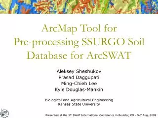
ArcMap Tool for Pre-processing SSURGO Soil Database for ArcSWAT. Aleksey Sheshukov Prasad Daggupati Ming-Chieh Lee Kyle Douglas-Mankin. Biological and Agricultural Engineering Kansas State University. Presented at the 5 th SWAT International Conference in Boulder, CO - 5-7 Aug, 2009.

E N D
ArcMap Tool for Pre-processing SSURGO Soil Database for ArcSWAT Aleksey Sheshukov Prasad Daggupati Ming-Chieh Lee Kyle Douglas-Mankin Biological and Agricultural Engineering Kansas State University Presented at the 5th SWAT International Conference in Boulder, CO - 5-7 Aug, 2009
Outline • STATSGO vs SSURGO • SSURGO in SWAT • Conversion Methodology • Tabular Datasets • Spatial Datasets • Linkage • Case Study • Conversion Tool for ArcSWAT • GIS Desktop Extension
Objectives • To develop/adopt methodology for processing SSURGO soils • To design a procedure/tool that converts SSURGO soil datasets into an ArcSWAT compatible format • To validate the conversion results • To make the tool user-friendly by creating an extension to ArcMap GIS
Soil Databases • STATSGO (1994) – State Soil Geographic Database • The map data are collected in 1- by 2-degree topographic quadrangle units and merged into a seamless national dataset with mapping scale about 1:250,000 • Distributed in state/territory and national extents • Designed for state level, river basin applications • The U.S. General Soil Map or STATSGO2 (2006) • Revised STATSGO • Distributed by the Natural Resources Conservation Service (NRCS) • Available at http://soils.usda.gov/survey/geography/statsgo • SSURGO – Soil Survey Geographic Database • Distributed by the Natural Resources Conservation Service (NRCS) • Mapping scales generally range from 1:12,000 to 1:63,360 • Most detailed level of soil mapping • Structured on county basis • Designed for use by landowners, townships, and county natural resource planning and management • Consists of spatial and tabular data files • Available at http://soildatamart.nrcs.usda.gov
STASTGO versus SSURGO • Soil name • Texture • Hydraulic Soil Group • Saturated Conductivity • USLE K-Factor • Databases structured differently • SSURGO – Data spread over 56 tables • STATSGO – One table
Soils in SWAT • SWAT utilizes STATSGO tabular format • The default U.S. soil database stored in State-named tables in Swat_US_Soils.mdb • All user defined soils must be added to ‘usersoil’ table in Swat2005.mdb • SWAT uses lookup table to link soil map grid with soil database • Lookup table fields used for linking: • Name • StMUID • StMUID+Name • StMUID+Seqn • S5ID
Available Conversion Tools • No Conversion Utilities for ArcSWAT • SSURGO SWAT 2.0 Extension by J. M. Peschel • http://lcluc.tamu.edu/ssurgo/ • Developed as an extension to Arcview 3.x • Works with Arcview SWAT • Does tabular datafiles conversion and clips spatial dataset to watershed boundary • Not adjusted for ArcMap • Not adjusted for ArcSWAT • References: • Peschel, J.M., P.K. Haan, and R.E. Lacey 2006. Influences of Soil Data Set Resolution on Hydrologic Modeling, Journal of the American Water Resources Association 42(5): 1371-1389 • Diluzio, M., Arnold, J.G., Srinivasan, R. 2004. Integration of SSURGO maps and soil parameters within a geographic information system and nonpoint source pollution model. Journal of Soil and Water Conservation. 59(4):123-133. • Manual step-by-step instructions found in discussion forums and SWAT community online • Have flaws and do not present a complete conversion utility
SSURGO Soil Database • 56 Tables with various data • Each table have a unique key identifier • Tables connected through one-to-many relationships • 5 tables identified for processing • Map unit - identifies the map units included in the referenced legend • Component - lists the map unit components identified in the referenced map unit, and selected properties of each component • Legend - identifies the soil survey area • Horizon - lists the horizons • Horizon fragments - lists the mineral and organic fragments that generally occur in the referenced horizon • Unique key identifiers • chkey • cokey • mukey • lkey
SWAT and SSURGO Variables Calculated Not required May be blank
Data Adjustment References: SWAT Input/Output File Documentation; SSURGO Metadata - Table Column Descriptions; Agriculture Handbook. Soil Taxonomy. USDA; Buol, S. W., 2003. Soil genesis and classification. Ames, Iowa
Linking Database With Map Lookup Table: Map Grid Table: Dataset:
Download Off SoilDataMart Data Acquisition Uncompress Tabular Data Spatial Dataset Data Preparation GIS Preparation Import Parameters Merge County Maps Conversion Scripts Project Layer Export to Dataset Convert to Raster Append to USERSOIL Data Linkage Build Lookup Table Soil Input ArcSWAT Extension SSURGO Data Conversion Flowchart
Case Study: Black Kettle Creek Watershed • Central Kansas • HUC-12 (11030012 ) Subbasin in Little Arkansas River Basin • Area – 7,818 ha • Landuse: Cropland (84%) • 9 subwatersheds (265-1845 ha) • STATSGO – 3 soils • SSURGO – 18 soils Presented by Prasad Daggupati at the Session B3: Field-scale targeting of cropland sediment yields
Percentage of C- and D-group Soils STATSGO-D STATSGO-C SSURGO-C SSURGO-D
Runoff and Sediment Yield STATSGO SSURGO
ArcMap Tool • Written in Visual Basic 6 • Data Access Objects (DAO) commands and queries used to import/export tabular datafiles • ArcObjects used to process SSURGO soil spatial datasets • ArcObjects used to create an extension, a toolbar, and a command in ArcMap GIS • Created as a ‘one-click’ operation
ArcMap Conversion Tool Folder containing input SSURGO datafiles Folder containing processed files Projection Delete individual soil data Lookup table Backup usersoil table
6 counties in KS 3 counties in MO Input/Output Files • Input files downloaded off SoilDataMart (http://soildatamart.nrcs.usda.gov), unzipped, and placed in one folder • Processed files placed in user-specified folder • Main database file • Lookup table • Shapefile feature class • Raster dataset • Soils for individual counties
Questions .. Thank You! • Tool Availability • Developed by Biological and Agricultural Engineering at K-State • Download from: http://www.bae.ksu.edu/watershed/ssurgo • Questions and Comments: ashesh@ksu.edu