
Advances in Tidal Flat Sediment Research: Insights from Global Case Studies
This chapter explores the characteristics and sedimentary processes of modern tidal flats, primarily composed of siliciclastic materials, but also featuring carbonates and evaporites in specific regions. It reviews historical studies from Germany, the Netherlands, the UK, and advances in China since the 1960s. The chapter discusses sedimentary structures, depositional settings, and tidal current dynamics, highlighting the importance of tidal flats as significant geological environments. It also examines sediment variations due to seasonal changes and storm impacts, providing valuable insights for researchers in coastal sedimentology.

Advances in Tidal Flat Sediment Research: Insights from Global Case Studies
E N D
Presentation Transcript
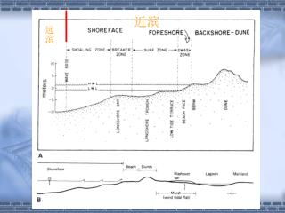
近滨 远滨
第三章 海岸带 滨、浅海地区的潮汐沉积
Modern tidal flats are primarily sites of siliciclastic deposition; however, carbonate sediments and, in a few areas, evaporites accumulate on some modern tidal flats such as those in the Bahamas, the Persian Gulf, Florida Bay, and the western coast of Australia. • Modern tidal flats have been studies intensively in many parts of the world since the 1950s, particularly in Germany; the North Sea coastline of the Netherlands; England; the Bay of Fundy, Nova Scotia; the west coast of Korea; and the Gulf of California.
潮坪沉积研究的进展 • 二次世界大战前德国Senckenberg 研究所从事北海潮坪沉积的研究, 至1973年发表关于潮坪沉积的文章500篇,其中90%发表于二次世界大战之后。 • 荷兰,德国,英国都是研究潮坪沉积最早的国家。 • 中国淤泥质海岸研究始于1960s
中国潮坪的分布 中国淤泥质海岸有4000多km,是研究潮坪沉积得天独厚的地方。中国潮坪可分三类:河口湾型,开敞型和港湾性。
Depositional setting • Tidal currents may operate in the ocean to depth of 2000 to 2500m. • Vertical distance between the high- and low-tide line in most modern tidal environments commonly ranges from 1 to 4m (mesotidal coasts). The total width of tidal flats may range from a few kilometers to as much as 25 km. • Topographic relief is generally rather small, except for tidal channels, and slopes of the tidal flat are gentle.
沉积滞后作用 • 代表人物:Van Straaten 和 Kunen(1950s) • 主要理论概念: 沉积滞后作用(Settling lag) • 推移质与悬移质在搬运和沉积上的的差异(颗粒启动流速和沉积临界流速差异);淤泥质海岸堆积前展的问题。
潮坪分带和潮坪层理 • 代表人物:Reineck (1960s – 1980s) • 潮上带,潮间带,潮下带 • 潮间带:高潮坪泥质带(泥坪);中潮坪沙泥混带(混合坪);低潮坪砂带(砂坪)。在潮下带有一个与之相反的相带分布。
lithofacies • Muds predominate in the supretidal and upper intertidal zones, and the deposits of supretidal marshes are further characterized by abundant plant debris, which may eventually form peat. Mixed mud and sand characterize the middle part of intertidal zone, and sand dominates the lower intertidal zone as well as the channel and bar deposits of the shallow subtidal zone. • Muds may be deposited between channels in the subtidal zone below wave base. • The proportion of mud and sand in modern tidal flats varies considerably.
潮成沉积构造的特征和组合 低潮坪 自上而下低潮坪至高潮平的沉积构造组合 中潮坪 高潮坪
潮坪层序的特征及形成 小型层序 = 大、小潮旋回 = 大、小潮沉积层序
不同季节潮坪砂质沉积层的厚度 平静天气时沉积泥质沉积物,小型层序内以泥质纹层为主。风浪天气时形成沙质单层,含泥质纹层。
泥砾 泥砾
风暴控制的海岸带沉积 • They predominate on most of the world’s coasts. They are characterized by low tidal current velocity (<25 cm/s) and fair-weather wave base is normally shallow (< -10m). • Modern examples: the Atlantic shelf off the eastern coast of U. S, the Pacific shelf off Oregon and Washington, the Bering Sea. • Sedimentation patterns may be quite complex, depending particularly upon the extent to which the shelves are mantled by relict sediments or modern sediments.
沉积相特征 • Coarse-grained “storm layers” and hummocky cross-stratification are sedimentary structures that appear to be characteristics of storm-dominated shelf sediments. • Storm layers are commonly thin layers consisting of concentrations of coarse grains interlayered or embedded in finer-grained muds and thus, show vertical size grading. • They are best developed on the inner shelf