Download

1 / 43
430 likes | 533 Views
SST Science Team Meeting 8-10 November 2010, Seattle WA. Towards Community Consensus SSTs and Clear-Sky Radiances from AVHRR. Sasha Ignatov NOAA/NESDIS Prasanjit Dash, Xingming Liang, Feng Xu NOAA/NESDIS and CSU/CIRA. Contributions. AVHRR Level 2/3 SST products

E N D
SST Science Team Meeting8-10 November 2010, Seattle WA Towards Community ConsensusSSTs and Clear-Sky Radiances from AVHRR Sasha Ignatov NOAA/NESDIS Prasanjit Dash, Xingming Liang, Feng Xu NOAA/NESDIS and CSU/CIRA SST Science Team Meeting
Contributions • AVHRR Level 2/3 SST products • J. Sapper, Y. Kihai, B. Petrenko, J. Stroup:ACSPO (GAC: 5 platforms, FRAC: MetOp-A) • P. LeBorgne:O&SI SAF MetOp-A FRAC • D. May, B. McKenzie:NAVO SEATEMP • K. Casey, T. Brandon, R. Evans, J. Vazquez, E. Armstrong:PathFinder v5.0 • Level 4 SST products (additional L4 SSTs are being tested) • R. Grumbine, Xu Li, B. Katz:RTG (Low-Res & Hi-Res), GSI • R. Reynolds:OISST (AVHRR & AVHRR+AMSRE) • M. Martin:OSTIA foundation, GHRSST Median Product Ensemble • D. May, B. McKenzie:NAVO K10 • E. Autret, J.-F. Piollé:ODYSSEA • E. Maturi, A. Harris, W. Meng:POES-GOES blended • B. Brasnett:Canadian Met. Centre, 0.2 foundation • AVHRR Radiances • C. Cao, X. Wu, J. Mittaz, A. Harris, A. Heidinger, L. Wang:AVHRR Cal • C. Cao, T. Hewison, M. König:GSICS (Global Space-based Inter-Cal System) • Y. Han, M. Liu, Y. Chen, P. Van Delst, D. Groff, F. Weng:CRTM SST Science Team Meeting
SST data come from various sources, sensors, and processing algorithms L2/L3 • POES • AVHRR (NESDIS, NAVO, O&SI SAF, U. Miami, NODC) • MODIS, ATSR, VIIRS, .. • Microwave • GOES • GOES (NESDIS, NAVO, O&SI SAF) • SEVIRI (NESDIS, O&SI SAF) • MTSAT (NESDIS, JAXA) L4 • Reynolds (AVHRR; +AMSR-E) • RTG (Low, High Resolution), GSI • OSTIA (UKMO) • ODYSSEA (France) • GMPE (GHRSST) • NAVO K10 • NESDIS POES-GOES Blended • JPL G1SST • CMC 0.2 (Canada) • GAMSSA (Australia) • JAXA (Japan) • RSS (MW, MW+MODIS) In situ • Sources • GTS, ICOADS, GODAE/FNMOC • Platforms • Drifters, Moorings, Ships, ARGO Floats • Quality Control • May be unavailable or non-uniform Are these products self-consistent?Cross-consistent? Processed using community consensus algorithms? SST Science Team Meeting
Initial Focus: AVHRR • Past: Climate Data Record • Pathfinder Ocean: 1981-present • Present: Initial Joint Polar System (IJPS) • NOAA/EUMETSAT Cooperation • NOAA: GAC (4km), NOAA-18 & -19 (2 pm/am) (NOAA-16 and -17 are also in orbit but degraded) • EUMETSAT: FRAC (1km) 3 mid-morning birds (9:30 am/pm) Metop-A (19 Oct 2006), -B (2012), -C (2016) • Future: Joint Polar Satellite System (JPSS) • Europe: AVHRR/3 onboard Metop-B (~2012) & -C (2016) • AVHRR will serve the data through at least 2021 • USA: Visible and IR Imagers Suite (VIIRS) on NPP & NPOESS • Need to ensure VIIRS/AVHRR synergy SST Science Team Meeting
Operational POES SST at NESDIS • Heritage Main Unit Task (MUT) • 1981 - pr (MCSST - McClain et al., 1985; NLSST - Walton et al., 1998) • 1993 - pr: Re-hosted to NAVO (“Shared Processing Agreement”). Robust end-to-end system. No fundamental redesign since 1981: Data sub-sampling (e.g. 2×2); No RTM; No reprocessing capability. • New Advanced Clear-Sky Processor for Oceans (ACSPO) • Development started in late 2005 (IJPS) - Operational in May 2008 Process all AVHRR pixels (GAC, FRAC). RTM & Reprocessing capability. • Joint Polar Satellite System (JPSS) • Generate AVHRR-like ACSPO products from VIIRS radiances. Fall-back for NPOESS SST. Benchmark to measure VIIRS improvements. Smooth transition for SST users. • Cross-evaluate against VIIRS SST generated by NPOESS contractor. Contractor’s cloud mask + VIIRS instrument + Heritage NLSST algorithm SST Science Team Meeting
Current AVHRR SST Products GAC ~4km Global Area Coverage NAVO SEATEMP NESDIS ACSPO (new); MUT (heritage) U. Miami + NODC Pathfinder Ocean (L3) MetOp FRAC ~1km Full Resolution Area Coverage NESDIS ACSPO (new) EUMETSAT O&SI SAF Cross-evaluate ACSPO against heritage MUT SST .. and against other available L2 AVHRR SST products SST Science Team Meeting
L2 vs. in situ Customary Validation SST Science Team Meeting
MUT SST versus in situ SST (no QC applied to in situ SST) Global Mean “SAT – In Situ” Global Std Dev “SAT – In Situ” Outliers in in situ data:Critically affect validation statistics SST Science Team Meeting
MUT SST versus in situ SST (after QC of match-up data) Global Mean “SAT – In Situ” Global Std Dev “SAT – In Situ” QC improves both moments (Mean, Std Dev). Most dramatically, it affects the Std Dev. Absolute values are sensitive to QC. SST Science Team Meeting
QC & Monitoring of in situ SST: Need community consensus • GHRSST coordinates efforts towards community consensus • Quality Control of in situ SST • Match-up procedures and practices • NESDIS contribution • Implement in situ QC consistent with the UK Met Office • Set up near-real time web-based in situ SST Quality Monitor (iQuam) http://www.star.nesdis.noaa.gov/sod/sst/iquam/ • Monitor QC’ed data against global L4 SST (currently, daily Reynolds) • Serve QC’ed in situ data to SST community, in near-real time • Work in progress • Validate L2/3/4 products against in situ SSTs, using consistent QC and match-up procedures • Evaluate match-up criteria and iQuam QC through sensitivity studies; Adjust as needed; Seek community consensus • Add ARGO floats to iQuam SST Science Team Meeting
iQuam webpagehttp://www.star.nesdis.noaa.gov/sod/sst/iquam/ SST Science Team Meeting
L2/3 vs. L4 Validation against global L4 SST Science Team Meeting
Validation against global L4 SSTs was first considered because… …in situ SSTs have limitations • Non-uniform / Suboptimal quality (may be worse than satellite SSTs) • Sparse, geographically biased, and do not cover retrieval domain, fully and uniformly • Not available in sufficient numbers in near-real time (limited statistics). Diagnostics delayed Using L4 products provides global snapshot (map) of TSAT performance, in near-real time, with uniform global coverage. Also, QC & smoothing done at L4 production stage. Errors of L4 SST are more uniform in space & time than for in situ data. SST Science Team Meeting
http://www.star.nesdis.noaa.gov/sod/sst/squam/ ΔTS=TSAT - TREF are mapped to identify issues in data, in near-real time (e.g., cold biases likely due to residual cloud) SST Science Team Meeting
O&SI SAF SST minus OSTIA Metop-A FRAC 16-Oct-2010 NIGHT NIGHT DAY DAY SST Science Team Meeting
NESDIS ACSPO SST minus OSTIA Metop-A FRAC 16-Oct-2010 NIGHT NIGHT DAY DAY SST Science Team Meeting
Statistics of ΔTSfor O&SI SAF and ACSPO Metop-A FRAC minus OSTIA NIGHT NIGHT NIGHT O&SI SAF ACSPO Median Difference Robust Standard Deviation Number of Observations (x 1.0e7) DAY DAY DAY O&SI SAF ACSPO O&SI SAF: ~40 M clear pixels/night and ~40 M/day. At night, ACSPO produces ~15% clear-sky ocean pixels than O&SI SAF. Global median biases and Robust Std Dev (RSD) wrt. OSTIA are comparable. During daytime, # of clear-sky ocean pixels comparable in ACSPO and O&SI. Global median biases: comparable; RSD: slightly smaller for ACSPO. SST Science Team Meeting
Pathfinder v5.0 (Day) - Reynolds SST http://www.star.nesdis.noaa.gov/sod/sst/squam/PF/ Reynolds OISST uses Pathfinder as input. Still, the two products may differ by several tenths K SST Science Team Meeting
“Pathfinder v5.0 (Day) - OISST” vs. Wind Speed NOAA-17 mid-morning platform – Diurnal warming suppressed Platforms Year http://www.star.nesdis.noaa.gov/sod/sst/squam/PF/ Wind Speed (ms-1) SST Science Team Meeting
L2-L4 statistics for various L2s (L4 = OSTIA) * +Attributes SST systems SST Science Team Meeting + Average NOAA-18 is shown. Outliers not removed
L2-L4 statistics for various L2s (L4 = Reynolds “AVHRR”) * +Attributes SST systems SST Science Team Meeting + Average NOAA-18 is shown. Outliers not removed **NB: 2006-pr OISST uses NAVO SEATEMP as input
Observations from validation against global L4 SSTs • Choice of L4 affects Mean and Std Dev statistics of L2-L4 Absolute values are L4-specific. • However, relative performance of L2 products can be evaluated using (L2-L4) analyses, with any L4. • Main advantage of L2 vs. L4: Product performance is monitored in near real time, using a global instantaneous view. Work in progress • Add MODIS and VIIRS SSTs to SQUAM. • Sensitivity to reference L4 calls for “L4 vs. L4” evaluation. • Although beyond our initial plans, our NCEP RTG colleagues suggested adding L4 comparisons to SST Quality Monitor. SST Science Team Meeting
L4 vs. L4 Cross-evaluation of various L4s SST Science Team Meeting
http://www.star.nesdis.noaa.gov/sod/sst/squam/L4/ Contribution to GHRSST Inter-Comparison Technical Advisory Group SST Science Team Meeting
“OSTIA – GMPE” mean zonal difference Year Latitude SST Science Team Meeting
“L4s– GMPE”: time series statistics More time-series at: www.star.nesdis.noaa.gov/sod/sst/squam/L4/l4_delsst_timeseries.htm Mean Std Dev wrt GHRSST GMPE wrt GHRSST GMPE Year Year Roughly, L4 products form 3 major groups: DOI_AV,DOI_AA,RTG_LR,NAVO K10 RTG_HR,GOES-POES blended (with seasonal variation between: RTG_HR, RTG_LR) OSTIA,CMC,&GMPE *ODYSSEA: production temporarily halted SST Science Team Meeting
Match-up statistics in SQUAM for various daily L4 products wrt. GMPE * +Attributes SST systems SST Science Team Meeting *robust parameters are resistant to outliers, may hide local issues. Should be used with additional diagnostics
Conclusion to L4 vs. L4 Comparisons Currently, nine L4 daily products are continuously monitored in SQUAM, wrt. each other. Foundation SST products (OSTIA, CMC) appear more stable in time, less noisy in space, and more consistent with satellite data. G1SST is being evaluated (G1SST). RSS MW is in pipeline. Future plans… Validate all L4 SSTs against independently QCedin situ data (iQUAM). Explore DV model. This should reduce cross-platform biases and spurious noise in “L2-L4”, and will help to globally validate the DV model. Cooperate with L4 producers to add missing L4s SST Science Team Meeting
Radiances Monitoring Clear-Sky Radiances SST Science Team Meeting
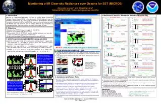
Monitoring of IR Clear-sky Radiances over Oceans for SST (MICROS) • Web-Based NRT tool to monitor M-O bias • M (Model) = Community Radiative Transfer Model (CRTM) used in ACSPO to simulate TOA Brightness Temperatures. • O (Observation) = AVHRR Clear-Sky BTs in Ch3B, 4 & 5. • Key objectives • Fully understand and reconcile CRTM and AVHRR BTs • Minimize cross-platform biases • Users/Applications • Test and improve ACSPO products • Validate and improve CRTM performance • Contribute to sensor characterization and inter-calibration within Global Space-based Inter-Calibration System (GSICS) SST Science Team Meeting
MICROS Overview MICROS is end-to-end system www.star.nesdis.noaa.gov/sod/sst/MICROS/ SST Science Team Meeting
M-O Biases and Double-Differences • Warm M-O biases are due to a combined effect of incomplete model (aerosols not included; bulk SST used instead of skin; daily mean Reynolds SST is used to represent nighttime SST) and biased satellite sensor radiances (residual cloud). • Double differences (DDs) cancel out many possible systematic errors in CRTM and its input (SST and GFS, missing aerosol, etc). • Non-zero DDs are mainly due to errors in sensor calibration and spectral response functions. Largest systematic errors are in N18 (Ch4) and N19 (all bands). • NOAA-16 is unstable in whole monitoring period. SST Science Team Meeting
The effect of CRTM input on M-O bias (Reynolds SST used as CRTM input) μ and σ: median and RSD over time Spurious variations found when Reynolds SST used as CRTM input. SST Science Team Meeting
The effect of reference SST on M-O bias (OSTIA SST used as CRTM input) Spurious time variability reduced when OSTIA used as CRTM input. The Std Deviations are also dramatically reduced. SST Science Team Meeting
Conclusion to Monitoring Radiances • SST is an unresolved combination of 2-3 sensor bands. Monitoring individual bands is needed to unscramble SST anomalies. • Web-based near-real time Monitoring of IR Clear-sky Radiances over Oceans for SST (MICROS) established http://www.star.nesdis.noaa.gov/sod/sst/micros/ • Currently, three users groups actively use MICROS • ACSPO SST developers • CRTM developers • Sensor calibration scientists Future plans… • Minimize M-O biases through: Adding aerosol in CRTM; Improving AVHRR sensor characterization; Improving CRTM accuracy SST Science Team Meeting
Conclusion Community Consensus SSTs & Radiances SST Science Team Meeting
Conclusion • Community consensus methodologies and tools for SST evaluation and validation are needed • Prototypes have been established at NESDIS • SST Quality Monitor (SQUAM) for L2 & L4 products http://www.star.nesdis.noaa.gov/sod/sst/squam/ • In situ SST Quality Monitor (iQuam) http://www.star.nesdis.noaa.gov/sod/sst/iquam/ • Satellite radiances in individual sensor bands should be monitored • Monitoring of IR Clear-sky Radiances over Oceans for SST http://www.star.nesdis.noaa.gov/sod/sst/micros/ • We are open to any suggestions to make SQUAM, iQuam, and MICROS the “community tools” SST Science Team Meeting
Questions? Thank you! SST Science Team Meeting
Back-Up slides SST Science Team Meeting
Effect of QC on NCEP GTS SST (in situ minus daily Reynolds) Ships Std Dev of “In Situ – Daily Reynolds SST” stratified by in situ data types Drifters Tropical Moorings All SSTs are strongly contaminated by outliers (drifters affected most). Coastal Moorings SST Science Team Meeting
Percent of NCEP GTS data excluded by QC Ships Percent of in situ data excluded by QC Drifters Tropical Moorings Percent of outliers in drifter SSTs is largest– QC is needed most. Coastal Moorings SST Science Team Meeting
Pathfinder v5.0 (Night) - Reynolds SST http://www.star.nesdis.noaa.gov/sod/sst/squam/PF/ Pathfinder v5 was recently added to SQUAM SST Science Team Meeting
Pathfinder v5.0 (Day) - Reynolds SST http://www.star.nesdis.noaa.gov/sod/sst/squam/PF/ Pathfinder v5 was recently added to SQUAM SST Science Team Meeting