A Cloud Object Based Volcanic Ash Detection Technique
A Cloud Object Based Volcanic Ash Detection Technique. Presented by Michael Pavolonis. Requirement, Science, and Benefit. Requirement/Objective Mission Goal: Commerce and Transportation

A Cloud Object Based Volcanic Ash Detection Technique
E N D
Presentation Transcript
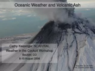
A Cloud Object Based Volcanic Ash Detection Technique Presented by Michael Pavolonis
Requirement, Science, and Benefit Requirement/Objective • Mission Goal: Commerce and Transportation • Research Area: Provide accurate, timely, and integrated weather information to meet air and surface transportation needs. Science • How can satellite data be used to quantitatively track dangerous volcanic ash clouds? How can satellite data products be used to validate and improve forecasts of ash cloud dispersion? Benefit • These products will allow forecasters to issue more timely and accurate ash cloud warnings and forecasts to the aviation community, helping to reduce the risk of ash/aircraft encounters and limit the economic impact associated with rerouting aircraft around suspected ash clouds. • The ash cloud property retrievals can be used to improve ash fall predictions. Ash fall poses a major hazard to life, property, and natural resources.
Challenges and Path Forward • Science challenges • Product validation is difficult given the lack of in-situ observations of ash clouds. • Next steps • Similar products are being developed for other sensors such as: GOES, MTSAT, MODIS, SEVIRI, VIIRS, GOES-R, AIRS, IASI, and CrIS. • Our goal is an automated combined LEO/GEO global volcanic ash monitoring system that will be a reliable tool for volcanic ash forecasters and modelers. • Transition Path • The AVHRR component of this system is scheduled to be fully transitioned into NESDIS operations by May/June 2010 (a PSDI funded effort). • We have developed the algorithm which will be used to generate the operational GOES-R ash products. • Our goal is to transition the GOES products to NESDIS operations within the next few years. • End users: Volcanic Ash Advisory Centers (VAACs), Air Force, NRL, Modeling Community, Research Community
Ash Detection Method Meteorological Clouds Volcanic Ash Algorithm Innovation #1: Spectral • In lieu of traditional brightness temperature differences, the ash detection algorithm utilizes effective absorption optical depth ratios (-ratios) (Pavolonis, 2010a and Pavolonis 2010b), which isolate the desired microphysical signatures. Algorithm Innovation #2: Spatial Candidate ash objects • Spatially connected candidate volcanic ash pixels are grouped into cloud objects. Spectral and spatial object statistics are used to determine which objects are ash clouds. 4
Ash Detection Method Meteorological Clouds Volcanic Ash Algorithm Innovation #1: Spectral • In lieu of traditional brightness temperature differences, the ash detection algorithm utilizes effective absorption optical depth ratios (-ratios) (Pavolonis, 2010a and Pavolonis 2010b), which isolate the desired microphysical signatures. Algorithm Innovation #2: Spatial Filtered ash objects • Spatially connected candidate volcanic ash pixels are grouped into cloud objects. Spectral and spatial object statistics are used to determine which objects are ash clouds. 5
Retrieval Method Ash Loading Effective Radius Ash Height • An optimal estimation technique (Heidinger and Pavolonis, 2009) is applied to ash pixels to retrieve cloud temperature, emissivity, and a micro-physical parameter. • The retrieved parameters are used to estimate cloud height, effective particle radius, and ash mass loading. • An error estimate for each of the retrieved parameters is a by-product of the optimal estimation approach. • These products can be used to improve ash dispersion and fallout forecasts. Quantitative Ash Products 6
Automated Ash Warning System • The warning criteria is fully user configurable. • In addition to the text message, an automatically generated, pre-analyzed false color image along with product images are supplied to the user. E-mail Warning Product Quick-look Quantitative description of ash cloud needed to issue accurate advisory 7
Automated Warning Performance False alarm April 1 and 4 eruptions March 23 - 27 eruptions False alarm • During this 20 day period leading up to and including the 2009 eruptions of Redoubt, AK, only 2 false warnings occurred out of 474 full AVHRR scenes received directly at Gilmore Creek (GC), AK (0.5% of scenes received at GC). • In other words, a forecaster can expect a false warning once every 7 to 10 days. • Every eruptive event captured by the AVHRR was detected. 8
Unique Early Warning Capability Remnant ash from previous eruption Early detection of new eruption (ash is largely sequestered in ice) • This is the first automated technique capable of identifying volcanic ash that is sequestered in ice, which is common in the early stages of the ash cloud lifecycle. 9
Challenges and Path Forward • Science challenges • Product validation is difficult given the lack of in-situ observations of ash clouds. • Next steps • Similar products are being developed for other sensors such as: GOES, MTSAT, MODIS, SEVIRI, VIIRS, GOES-R, AIRS, IASI, and CrIS. • Our goal is an automated combined LEO/GEO global volcanic ash monitoring system that will be a reliable tool for volcanic ash forecasters and modelers. • Transition Path • The AVHRR component of this system is scheduled to be fully transitioned into NESDIS operations by May/June 2010 (a PSDI funded effort). • We have developed the algorithm which will be used to generate the operational GOES-R ash products. • Our goal is to transition the GOES products to NESDIS operations within the next few years. • End users: Volcanic Ash Advisory Centers (VAACs), Air Force, NRL, Modeling Community, Research Community