Download

1 / 61
610 likes | 812 Views
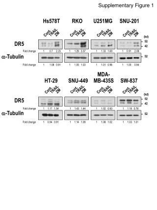
Status of Indonesia’s Geodetic Infrastructure: Case Study at the National Land Agency (BPN), Indonesia. Sunantyo , T.A., Geodetic Department, Faculty of Engineering, Gadjah Mada University, Yogyakarta, Indonesia sunantyo@yahoo.com

E N D
Status of Indonesia’s Geodetic Infrastructure: Case Study at the National Land Agency (BPN), Indonesia Sunantyo, T.A., Geodetic Department, Faculty of Engineering, GadjahMada University, Yogyakarta, Indonesia sunantyo@yahoo.com Haroen, M. T. S., Director of Basic Survey, National Land Agency, Indonesia tony_s_haroen@yahoo.com
Outline :1. Introduction2. Type of infrastructure, equipment, description of a “typical” GNSS CORS3. Description of Control Centre
Outline (Cont.): 4. Survey Control Marks or GNSS CORS Stations5. Geodetic Services 6. Users 7. Issues to be Resolved 8. Future plans to modernise their geodetic frame work 9. Conslusion
Introduction Historically, the development of geodetic infrastructure in Indonesia was predominantly for surveying and mapping. Since 1990, GPS technology has been used for survey and mapping activities in Indonesia, especially horizontal control networks (1st, 2nd, 3rd and 4th orders). GPS CORS has been growing in Indonesia. Stake holders who have managed more than 200 GPS CORS are Geospatial Information Agency, the National Land Agency (BPN), several national universities i.e. ITB, UGM, UNDIP and ITS, and a few private sectors.
Introduction (Cont.) 3. Jaringan Referensi Satelit Pertanahan (JRSP) is a reference stations network system which works continuously for 24 hours nonstop (active station) as CORS. It can also be applied to dynamic cadastre, geodetic framework that is as dynamic and has a homogeneous accuracy.
Introduction (Cont.) (b) (a) (c) Fig. JRSP pillars at Tangerang, Bogor and Bekasi of National Land Agency offices (Adiyanto and Wibisono, 2009)
Introduction (Cont.) Fig. Several pilars have been operated by Geospatial Inforantion Agency
Introduction (Cont.) JRSP Server consists of Site Server; Network Server; Storage Server and Spiderweb Server.
Introduction (Cont.) Site Server Receiver Management, File product Rinexdan Raw data Data link information
Introduction (Cont.) Fig. Site Server
Serves as a repository Raw Data / RINEX from Site Fig. Storage Server
Spiderweb Server Interface of Web-based SpiderNet www.BPNRI-CORS.net/portal Information regarding the status of services CORS National Land Agency Indonesia Download RINEX Processing Post Processing
Description of Control Centre This software is used for : a).Managing a wide range of devices to work according to its function; b).Regulating and monitoring the activities of reference stations; c).Controlling activity in the reference station network; d).Monitoring conditions recording of satellite data received by each reference station;
e).Managing data and make corrections to the rover position coordinates, f).Regulating data transmission over the Internet, and g). Other functions related to the calculation or the calculation of the position coordinates and differentiation of data presentation.
Description of Control Centre (cont.) Two types of data communication : 1. Via terrestrial infrastructure 2. Via satellites. Terrestrial data communication uses the media as a wired and wireless access (direct data connections, frame relay, VPN Multi-Service, and communication connection data packets). Connection between the reference station to the server or to a control center is used via several types of data communication.
Description of Control Centre (cont.) At National land agency, the data is sent to the server or the control center for encapsulation encrypted (wrapped) and as if passed at a virtual tunnel or tunnels (virtual tunnel). With the method of Virtual Private Network (VPN), then the safety and quality of the data flow from the reference station to a central server to be more secure (Idrus, 2009). VSAT-IP works with IP based method.
Table Data Communication Type between the JRSP and Control Center (Network Server)
Table Data Communication Type between the JRSP and Control Center (Network Server)
Fig. Distribution of JRSP at National Land Agency (Abidin et,al, 2012)
Fig. Distribution of Indonesian Continuous GPS (cGPS) Station Network status in 2010managed by Geospatial Information Agency (Subarya, 2013)
Geodetic Services Law No.11/ 4 of 2011 on Geospatial Information (Undang Undang Informasi geospasial, UUIG) is the first legislation governing the implementation of Geospatial Information in Indonesia. UUIG also encourages the use of a single reference (single reference) in the implementation of the Geospatial Information Base (IGD).
Geodetic Services (Cont.) National Geospatial Reference System (SRGN) is a 4-dimensional reference system (includes a 3-dimensional position and epoch) which is used as a reference in all activities related to geospatial information, such as mapping, cadastral, precision navigation, engineering work, as well as studies geoscience, geodinamic and other.
Geodetic Services (Cont.) The National Geospatial Reference System (SRGN) is a system and national infrastructure, data, software, and knowledge that evolve continuously. The SRGN in Indonesia is managed and maintained by the Geospatial Information Agency (BIG). The SRGN is a foundation for all positioning activities, the collection, and spatial data management.
Geodetic Services (Cont.) JRSP will be one of national potential networks to define SRGN. In the application of this new SRGN, datum is a datum defined semi-dynamic conditions that facilitate the movement of the earth's crust. Thus this datum will be updated periodically. Basically SRGN function is as a national reference for mapping the coordinates of a mapping activity.
Geodetic Services (Cont.) The main geodetic services of CORS network at the National Land Agency is for the primary source for control surveys of cadastral mapping. It is also possible to be used horizontal geodetic datum. JRSP is built to simplify and accelerate the achievement of orderly land, increase productivity and accuracy, as well as improving the quality of public services in the field of surveying, measurement, and mapping.
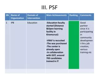
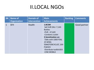
Users The main users of CORS network at the National Land Agency are all of regencies and provinces National Land Agency, Indonesia. It also can be used to some users (individual, private and national office) who get approval from National Land Agency office to access JRSP (real time observation or post observation). It is also used part of national network for scientific activities such as plate tectonic studies, datum maintenance etc.
Issues to be Resolved Applieddatum in Indonesian are Bessel 1941, Indonesian Datum 1974 (ID’74) and recently National Geodetic Datum (DGN95)which is geocentric by associating to the International Terrestrial Reference Frame (ITRF) and the World Geodetic System (WGS84) as a reference Ellipsoid.
Issues to be Resolved (Cont.) The parameters of National Geodetic Datum (DGN) 1995 are semi major axis (6378137.000 m) and semi minor axis (6356752.3142 m), and flattening (f) where 1/f is 298.257223563 m. The National Geodetic Datum (DGN95) is used for national reference frame, survey and mapping in several offices such as in the National Land Agency, Geospatial Information Agency, national private companies and so on.
Service Users: RTK DGPS RINEX Service This year the service will be upgraded to the Online Processing service
Table Activity limitation survey and measurement utilizing JRSP in urban areas and Rural
Table Activity limitation survey and measurement utilizing JRSP in urban areas and Rural (Cont.)
Table Activity limitation survey and measurement utilizing JRSP in urban areas and Rural (cont.)
Table Activity limitation survey and measurement utilizing JRSP in urban areas and Rural (cont.)
Future plans and APREF The purpose of the construction of the Land Resources Satellite (JRSP) is to facilitate and accelerate the realization of orderly Land Administration including land registration activities, including the activities of surveying, mapping, and bookkeeping ground, with precision / high accuracy, with a lower cost when compared to other terrestrial measurement methods.