Download
1 / 17
170 likes | 194 Views
Utilizing smart sensors, this system provides timely alerts and data processing for improved volcanic hazard assessments and risk management. It integrates with in-situ and airborne sensorwebs for enhanced monitoring capabilities.

E N D
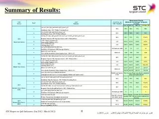
AIST Program Sensor Web Meeting Summary of Results Working Group C – Smart Sensing Presenter April 3, 2008 MW1 Model Interop MW2 System Mgmt SS Smart Sensing
Use Case Brainstorming Summary • 11 Use Cases • Soil Moisture Calibration and Validation for SMAP, Mahta Moghaddam • Model-based Volcano Sensor Web with Smart Sensors, Ashley Davies (PRIMARY) • Volcanic hazard event ground-space-ground feedback cycle, Wenzhan Song • COASTAL--SENSORWEB-SMARTSENSING, Ashit Talukder, John Dolan • Wildfire Sensor Web with UAVSAR, Yunling Lou & Steve Chien • Glacier Outburst Flood Water Quality Impact, Matt Heavner, Dipa Suri, Gautam Biswas • Snow Cover ASE+LIS, Steve Chien, Paul Houser, Christa Peters-Lidard Sensor Web Meeting, Working Group C – Smart Sensing
Use Case Brainstorming Summary – Con’t. • SOIL MOISTURE ACTIVE-PASSIVE (SMAP) high resolution foliage calibration, Larry Hillard • Snow and Cold Land Processes (SCLP) using ERINode for Passive Active Interferometric Radiometer w/Interleaved Radar, Larry Hillard • ICESat-II and Deformation, Ecosystem Structure, and Dynamics (DESDynl) using ERINode for Passive Active Interferometric Radiometer w/Interleaved Radar, Larry Hilliard • Calibration of Remote-Sensing Instruments Using Re-deployable In-Situ Sensor Networks for Ice Sheet Characterization, Ayanna Howard Sensor Web Meeting, Working Group C – Smart Sensing
Model-based Volcano Sensor Web POC: Ashley Davies, Steve Chien Goal Rapidly obtain high-resolution data describing volcanic activity to improve timeliness of hazard and risk assessments Summary Alert generated by system monitoring volcano (SOS, WCS, SAS) Alert triggers workflow; observation request generated (SPS) EO-1 observation scheduled Hyperion observation obtained Observation processed onboard EO-1 by ASE (THERMAL, CLOUD [day]) Ground processing and data delivery (WPS) Data delivered to relevant scientists and authorities Synergistic with in-situ and airborne sensorwebs as alert sources and taskable response assets Sensor Web Meeting, Working Group C – Smart Sensing Sensor Web Meeting, Working Group C – Smart Sensing 4
Model-based Volcano Sensor Web • Characterization • Decadal Missions • DESDynl • GEO-CAPE • HyspIRI • Current Missions • Aqua • NMP EO-1 • Terra • Future Missions • LDCM • NPOES • NPPDecadal Survey Categories • NMP EO-1 • Decadal Survey Category • Weather - Space and Chemical • Climate variability and changes • Water resources & global hydrologic cycle • Sensor Web Features & Benefits • Targeted observations (Main Feature) • Rapid Response (Main Benefit) • AIST Needs Category • 1-Data Collection • B-Coord multiple observations for synergistic science Sensor Web Meeting, Working Group C – Smart Sensing
Volcano Sensorweb Flow Sensor Web Meeting, Working Group C – Smart Sensing Sensor Web Meeting, Working Group C – Smart Sensing 6
Soil Moisture Calibration and Validation for SMAP • POC: • Mahta Moghaddam • Goal • To provide accurate and cost-effective means of validating and calibrating satellite-derived soil moisture products • Summary • 36 soil moisture probe sensors are in place (e.g., Fraser National Park, Colorado); each takes measurement of soil moisture and sends data to Coordinator • Coordinator uses the current state of sensor web and a time evolution model (such as SWAP) run in ensemble mode to formulate a partially observable Markov Decision Process (POMDP) optimization problem • Control strategy is derived by numerically solving POMDP: commands each node to perform a measurement at the next time step or estimate “measurement” from model • The controller decision optimizes sensor web performance with respect to power consumption and perceived error in estimate Sensor Web Meeting, Working Group C – Smart Sensing
Soil Moisture Calibration and Validation for SMAP • Decadal Missions • DESDynl • SMAP • Current Missions • None identified • Future Missions • NPOES • Decadal Survey Category • Weather - Space and Chemical • Climate variability and changes • Water resources & global hydrologic cycle • Characterization: • Sensor Web Features & Benefits • Incorporate feedback • Improve data quality/science value • AIST Needs Category • 1-Data Collection • 2-Transmission & Dissem. • 3-Data & Info Production • 5-Systems Mgmt • A-Increase science data value thru autonomous use • F-Decrease mission risk/cost thru autonomy/automation Sensor Web Meeting, Working Group C – Smart Sensing
Data SoilSurface 2.0 m Control Soil Moisture Calibration and Validation for SMAP • Field Implementation Scenario • Soil moisture is a complex function of landscape and external forcings at multiple spatial and temporal scales • In-situ sensor web is deployed at optimum locations to capture spatial variabilities • Coordinator receives sensor data and commands sensors to take data at optimal times based on the solution of the POMDP problem, with constraints derived from physics-based soil moisture evolution model Sensor Web Meeting, Working Group C – Smart Sensing
Forest Fire Sensor Web with UAVSAR • POC: • Yunling Lou & Steve Chien • Goal • Reduce time required to obtain critical information for rapid response to forest fires • Summary • Alert generated by forest fire observer or MODIS RapidFire • Alert detected by Sensor Web • Alert passed to onboard planner, UAVSAR observation request generated • UAVSAR observation obtained • Process data onboard to generate fuel load map • Downlink information to Forest Services and disaster management authority • Generate new alert for other sensor observation assets (e.g. EO-1) • Plan new data takes for UAVSAR • Repeat steps 4 through 8 until flight ends • Archive data for further analysis and future planning • Publish results to ecologists Sensor Web Meeting, Working Group C – Smart Sensing
Wildfire Sensor Web with UAVSAR • Decadal Missions • DESDynl • SCLP • SMAP • Current Missions • NMP EO-1 • Terra • Future Missions • None identified • Decadal Survey Category • Earth Science Apps & Societal Benefits • Land use change, ecosys. dynamics, biodiv. • Solid earth haz., resources, dynamics • Characterization: • Sensor Web Features & Benefits • Targeted observations (Main Feature) • Incorporate feedback • Ready access to data • Rapid Response (Main Benefit) • Improve cost effectiveness • AIST Needs Category • 1-Data Collection • 3-Data & Info Production • A-Increase science data value thru autonomous use • B-Coord multiple observations for synergistic science Sensor Web Meeting, Working Group C – Smart Sensing
MODIS Rapid Fire Schedule new UAVSAR data-take (UAVSAR SPS) DEMs and historical Vegetation Maps prepared/obtained (Other OGC SOSs) UAVSAR triggered on alert Flight Begins. Autonomy or new requests alter flight plan (SPS) Real-time Fuel-Load Maps generated and alert sent (SAS) Flight Ends Full SAR data made available and alert sent (SOS, SAS) Forest Fire Sensor Web with UAVSAR Sensor Web Meeting, Working Group C – Smart Sensing
Glacier Outburst Flood Water Quality Impact POC: Matt Heavner, Dipa Suri, Gautam Biswas Goal Better understanding of Long term ecological effects of increased glacial lake formation resulting from climate change Transient lake drainage effects on water quality and glacial dynamics Summary Pressure Transducer Measurement is forwarded to science agent at Cairn Peak met station Science agent identifies drop in lake pressure using forwarded data Science & Comm agents broadcast “lake drainage alert” (OGC SAS/SNS) Science agent requests additional satellite observations (visible imagery of glacier, imagery of soil moisture, Laser altimetry, InSAR for glacier rise/fall) Science agent commands Cairn Peak camera to point at lake to record drainage Science and Power Management agent reconfigure the glacial GPS and water quality sonde unit s to be in high accuracy, high sampling rate modes Poses potential for exhausting available power since this transient event is high priority. After lake drainage impacts on watershed conclude, sensor web “resets” for long-term monitoring Sensor Web Meeting, Working Group C – Smart Sensing Sensor Web Meeting, Working Group C – Smart Sensing 13
Glacier Outburst Flood Water Quality Impact • Characterization: • Decadal Missions • DESDynl • ICESat-II • SMAP • Current Missions • ICESat • Future Missions • None identified • Decadal Survey Category • Climate variability and changes • Water resources & global hydrologic cycle • Sensor Web Features & Benefits • Targeted observations • Rapid Response • AIST Needs Category • 1-Data Collection • A-Increase science data value thru autonomous use • B-Coord multiple observations for synergistic science • C-Improve interdiscip science production environs Sensor Web Meeting, Working Group C – Smart Sensing
Use Case Lessons Learned • Identify “collective results” of looking at several use case • Use of in-situ networks for cal/val of remote sensing data • Use of airborne assets to compliment remote sensing through increased modality or increase resolution • Feedback and adaptation of sensor nodes in response to events • Implications for next steps • Need to look more closely at return on investment for these use cases • Strengthen relevance to Decadal Survey missions • Suggestions on how to promote use cases • Tailor use cases to audience • Market use cases that relate to the science discipline lead’s “pet projects” • Provide feedback to ESTO AIST team Sensor Web Meeting, Working Group C – Smart Sensing
New Sensor Web Features, Needs • Identify new features or benefits • N/A • List any new AIST needs • N/A Sensor Web Meeting, Working Group C – Smart Sensing
Recommendations • Suggestions for ESTO next steps • Need to look more closely at return on investment for these use cases • Strengthen relevance to Decadal Survey missions and GEOSS/CEOS • Identify specific individuals for sensor web follow up • How can AIST or info systems in general, influence planning for Decadal Survey missions • Other Sensor Web Meeting, Working Group C – Smart Sensing