Download
1 / 34
340 likes | 395 Views
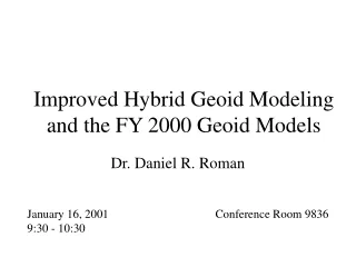
Datum Shifts and Geoid Height Models. Session C of Datums, Heights and Geodesy Presented by Daniel R. Roman, Ph.D. Of the National Geodetic Survey. h. N. Geoid Height (GEOID03). Ellipsoid (NAD 83). Geoid (NAVD 88). Ellipsoid, Geoid, and Orthometric Heights.

E N D
Datum Shifts and Geoid Height Models Session C of Datums, Heights and Geodesy Presented by Daniel R. Roman, Ph.D. Of the National Geodetic Survey
h N Geoid Height (GEOID03) Ellipsoid (NAD 83) Geoid (NAVD 88) Ellipsoid, Geoid, and Orthometric Heights H = Orthometric Height(NAVD 88) h = Ellipsoidal Height (NAD 83) H = h - N N = Geoid Height (GEOID 03) TOPOGRAPHIC SURFACE H A B
Transforming Between Ellipsoid Reference Frames • Most ellipsoids use the same shell (GRS-80) • They mainly differ by the location of the center of the reference frame (geocenter) • The geocenters are re-determined periodically in the International Terrestrial Reference Frame (ITRF) • Successive ellipsoid datums can be related to earlier models • Transforming ellipsoids is easy, because they are math constructs (a, f, GM, ω) • “14-parameter transformation” sounds intimidating, but it’s not: translation along X, Y, & Z (3), rotation around X, Y & Z (3) and scaling (1) plus velocities along all 7 of these. • Horizontal Time Dependent Positioning (HTDP) enables this • http://www.ngs.noaa.gov/TOOLS/Htdp/Htdp.shtml
Simplified Concept of ITRF 00 vs. NAD 83 h83 h00 Earth’s Surface ITRF 00 Origin 2.2 meters NAD 83 Identically shaped ellipsoids (GRS-80) a = 6,378,137.000 meters (semi-major axis) 1/f = 298.25722210088 (flattening) Origin
GEOID90 GEOID93 GEOID96 GEOID99 GEOID03 GEOID06 Earliest model – gravimetric only Another early gravimetric geoid First hybrid geoid (2’x2’) – CONUS only Underlain by G96SSS gravimetric model Still fairly heavily used (1’x1’) - CONUS Underlain by G99SSS gravimetric model Models tie to NAD 83 everywhere – hybrid in CONUS Underlain by the USGG2003 gravimetric model Forthcoming this year. Available for Alaska already. Will tie to NAD 83 and NAVD 88/PRVD02/etc. Various NGS Geoid models
h h h h H h H H H N N N N N H Earth’s Surface Composite Geoids • Gravimetric Geoidsystematic misfit with benchmarks • Composite Geoidbiased to fit local benchmarks • e = h – H - N Ellipsoid Hybrid or Composite Geoid =~ NAVD 88 0.055 M in Lakewood, CO – 1999 model 0.015 M in Lakewood, CO – 2003 model NGS Gravimetric Geoid
h h h h H h H H H N N N N N H Earth’s Surface Composite Geoids with GPS Random Errors • Gravimetric Geoidsystematic misfit with benchmarks • Composite Geoidbiased to fit local benchmarks • e = h – H - N Ellipsoid Hybrid or Composite Geoid =~ NAVD 88 NGS Gravimetric Geoid
GPSBM selection criteria • A, B, and 1st order GPS only • ABCRMH criteria for 1st, 2nd, and 3rd order leveling • A: Adjusted • B: Hand Keyed but not Verified • C: Computed from nearby Bench Marks • R: Reset • M: Readjusted due to earth movement • H: From Horizontal Branch. Based on quality and distribution • Prefer only A & B order GPS on 1st order leveling
High Resolution Geoid ModelsGEOID03 (vs. Geoid99) • Begin with USGG2003 model • 14,185 NAD83 GPS heights on NAVD88 leveled benchmarks (vs. 6169) • Determine national bias and trend relative to GPS/BMs • Create grid to model local (state-wide) remaining differences • ITRF00/NAD83 transformation (vs. ITRF97) • Compute and remove conversion surface from USGG2003
High Resolution Geoid ModelsGEOID03 (vs. Geoid99) • Relative to non-geocentric GRS-80 ellipsoid • 2.4 cm RMS nationally when compared to BM data (vs. 4.6 cm) • RMS 50% improvement over GEOID99 (Geoid96 to 99 was 16%)
Single Gaussian Function (GEOID99) More Fun with Formulas! Least Squares Collocation Multiple Gaussian Functions (GEOID03)
CO & National Statistics for GEOID03 For more details on the development of GEOID03, see: Daniel R. Roman, Yan Ming Wang, William Henning, and John Hamilton Assessment of the New National Geoid Height Model—GEOID03, Surveying and Land Information Science, Vol. 64, No. 3, 2004, pp. 153-162
Sample Datasheet • National Geodetic Survey, Retrieval Date = DECEMBER 28, 2005 • PL0314 *********************************************************************** • PL0314 DESIGNATION - V 27 • PL0314 PID - PL0314 • PL0314 STATE/COUNTY- MI/GRAND TRAVERSE • PL0314 USGS QUAD - • PL0314 • PL0314 *CURRENT SURVEY CONTROL • PL0314 ___________________________________________________________________ • PL0314* NAD 83(1994)- 44 39 02.41202(N) 085 46 04.27942(W) ADJUSTED • PL0314* NAVD 88 - 257.838 (meters) 845.92 (feet) ADJUSTED • PL0314 ___________________________________________________________________ • PL0314 X - 335,419.145 (meters) COMP • PL0314 Y - -4,532,722.532 (meters) COMP • PL0314 Z - 4,459,971.520 (meters) COMP • PL0314 LAPLACE CORR- 5.18 (seconds) DEFLEC99 • PL0314 ELLIP HEIGHT- 223.17 (meters) (07/17/02) GPS OBS • PL0314 GEOID HEIGHT- -34.68 (meters) GEOID03 • PL0314 DYNAMIC HT - 257.812 (meters) 845.84 (feet) COMP • PL0314 MODELED GRAV- 980,508.8 (mgal) NAVD 88 • PL0314 H h N
Sample Datasheet • PL0314 • PL0314 HORZ ORDER - FIRST • PL0314 VERT ORDER - FIRST CLASS II • PL0314 ELLP ORDER - FOURTH CLASS I • PL0314 • PL0314.The horizontal coordinates were established by GPS observations • PL0314.and adjusted by the National Geodetic Survey in February 1997. • PL0314 • PL0314.The orthometric height was determined by differential leveling • PL0314.and adjusted by the National Geodetic Survey in June 1991. • PL0314 • PL0314.The X, Y, and Z were computed from the position and the ellipsoidal ht. • PL0314 • PL0314.The Laplace correction was computed from DEFLEC99 derived deflections. • PL0314 • PL0314.The ellipsoidal height was determined by GPS observations • PL0314.and is referenced to NAD 83. • PL0314 • PL0314.The geoid height was determined by GEOID03. • PL0314 • PL0314.The dynamic height is computed by dividing the NAVD 88 • PL0314.geopotential number by the normal gravity value computed on the • PL0314.Geodetic Reference System of 1980 (GRS 80) ellipsoid at 45 • PL0314.degrees latitude (g = 980.6199 gals.). • PL0314 • PL0314.The modeled gravity was interpolated from observed gravity values. • PL0314
Sample Datasheet • PL0314 • PL0314.The modeled gravity was interpolated from observed gravity values. • PL0314 • PL0314; North East Units Scale Factor Converg. • PL0314;SPC MI C - 149,194.606 5,888,865.237 MT 0.99992569 -0 59 23.3 • PL0314;SPC MI C - 489,483.62 19,320,424.01 FT 0.99992569 -0 59 23.3 • PL0314;UTM 16 - 4,944,883.803 597,700.224 MT 0.99971738 +0 51 57.6 • PL0314 • PL0314! - Elev Factor x Scale Factor = Combined Factor • PL0314!SPC MI C - 0.99996501 x 0.99992569 = 0.99989070 • PL0314!UTM 16 - 0.99996501 x 0.99971738 = 0.99968240 • PL0314 • PL0314 SUPERSEDED SURVEY CONTROL • PL0314 • PL0314 ELLIP H (02/03/97) 223.19 (m) GP( ) 4 1 • PL0314 NAD 83(1986)- 44 39 02.41257(N) 085 46 04.28315(W) AD( ) 1 • PL0314 NAD 83(1986)- 44 39 02.38347(N) 085 46 04.27988(W) AD( ) 3 • PL0314 NAVD 88 (09/30/91) 257.84 (m) 845.9 (f) LEVELING 3 • PL0314 NGVD 29 (??/??/92) 257.915 (m) 846.18 (f) ADJ UNCH 1 2 • PL0314 • PL0314 Superseded values are not recommended for survey control. • PL0314.NGS no longer adjusts projects to the NAD 27 or NGVD 29 datums. • PL0314
Sample Datasheet • PL0314_U.S. NATIONAL GRID SPATIAL ADDRESS: 16TEQ9770044884(NAD 83) • PL0314_MARKER: DB = BENCH MARK DISK • PL0314_SETTING: 7 = SET IN TOP OF CONCRETE MONUMENT • PL0314_SP_SET: CONCRETE POST • PL0314_STAMPING: V 27 1930 846.176 • PL0314_MARK LOGO: CGS • PL0314_MAGNETIC: N = NO MAGNETIC MATERIAL • PL0314_STABILITY: B = PROBABLY HOLD POSITION/ELEVATION WELL • PL0314_SATELLITE: THE SITE LOCATION WAS REPORTED AS SUITABLE FOR • PL0314+SATELLITE: SATELLITE OBSERVATIONS - October 24, 1992 • PL0314 • PL0314 HISTORY - Date Condition Report By • PL0314 HISTORY - 1930 MONUMENTED CGS • PL0314 HISTORY - 1951 GOOD NGS • PL0314 HISTORY - 1984 GOOD NGS • PL0314 HISTORY - 19890428 GOOD NGS • PL0314 HISTORY - 1990 GOOD USPSQD • PL0314 HISTORY - 19910701 GOOD NGS • PL0314 HISTORY - 19920824 GOOD MIDT • PL0314 HISTORY - 19921024 GOOD MIDT • PL0314 HISTORY - 19971029 GOOD USPSQD • PL0314 • PL0314 STATION DESCRIPTION • PL0314 • PL0314'DESCRIBED BY NATIONAL GEODETIC SURVEY 1951 • PL0314'IN INTERLOCHEN. • PL0314'AT INTERLOCHEN, 131 FEET EAST OF THE JUNCTION OF THE ABANDONED • PL0314'BRANCH OF THE MANISTEE AND NORTHEASTERN RAILROAD AND THE C AND
Sample Datasheet • National Geodetic Survey, Retrieval Date = DECEMBER 28, 2005 • PL0314 *********************************************************************** • PL0314 DESIGNATION - V 27 • PL0314 PID - PL0314 • PL0314 STATE/COUNTY- MI/GRAND TRAVERSE • PL0314 USGS QUAD - • PL0314 • PL0314 *CURRENT SURVEY CONTROL • PL0314 ___________________________________________________________________ • PL0314* NAD 83(1994)- 44 39 02.41202(N) 085 46 04.27942(W) ADJUSTED • PL0314* NAVD 88 - 257.838 (meters) 845.92 (feet) ADJUSTED • PL0314 ___________________________________________________________________ • PL0314 X - 335,419.145 (meters) COMP • PL0314 Y - -4,532,722.532 (meters) COMP • PL0314 Z - 4,459,971.520 (meters) COMP • PL0314 LAPLACE CORR- 5.18 (seconds) DEFLEC99 • PL0314 ELLIP HEIGHT- 223.17 (meters) (07/17/02) GPS OBS • PL0314 GEOID HEIGHT- -34.68 (meters) GEOID03 • PL0314 DYNAMIC HT - 257.812 (meters) 845.84 (feet) COMP • PL0314 MODELED GRAV- 980,508.8 (mgal) NAVD 88 • PL0314 H h N NAVD88 – Ellip Ht + Geoid Ht = … 257.838 – 223.17 – 34.953 = -0.285 USGG2003 257.838 – 223.17 – 34.68 = -0.012 GEOID03
Other Types of Transformations • VERTCON: NGVD 29 to NAVD 88 • NADCON: NAD 27 to NAD 83 • VDATUM: Transforms between all surfaces using a lot of the tools and models you’ve seen here
VERTCON 2.0 • Used 381,833 points where both NAVD 88 and NGVD 29 were known • Second version updated to incorporate a forward physical model => yielded better results • Most recently, southern Florida region was remodeled to provide improved height changes • While overall internal agreement is at the 2 cm level (one sigma) – reliability in sparser regions is probably closer to the dm-level or worse.
NADCONLatitude Longitude • Used more than 150,000 horizontal control points • The accuracy of transformations between NAD 27 and NAD 83 (1986) are typically 12-18 cm and 5-6 cm between NAD 83 (1986) and HPGN. • NADCON is the Federal standard for NAD 27 to NAD 83 datum transformations.
Plans for Geoid Modeling at NGS • Near term plans are to define gravimetric geoids and hybrid geoids for all U.S. territories (USGG2006 & GEOID06). • Gravimetric geoids would all have a common Wo value (geoid datum) and be based on GRACE-based global gravity models such as the forthcoming EGM07 from NGA • Gravimetric geoids will be tested against tide gauges and lidar-observed sea surface heights to confirm choice of Wo. • Hybrid geoids would be tied to NAD 83 & local vertical datums • NAVD 88 for Alaska and CONUS • PRVD02 for Puerto Rico • Etc. • The quality of VDatum will be improved as the ties between the oceanic and terrestrial datums are better understood. • Likewise, it would be very useful in providing decimeter or better accurate heights to estimate flooding potential.
Plans for Geoid Modeling at NGS (cont.) • Long term goals are to define a cm-level accurate geoid height model valid for all of North America • Work is ongoing with the Canadians • Other nations joining in (Mexico/INEGI, etc.) • We likely will also adopt a vertical datum based on a refined geoid height model – the ultimate in Height Mod! • Conversion surface will provide means of transforming between this new datum and NAVD 88 – much as VERTCON does now between NGVD 29 and NAVD 88. • This maintains compatibility with archival data. • To do this, several major areas need work: • Gravity database cleansing/analysis/standardization • Acquisition of additional data sets • Refinement of geoid theory
QUESTIONS? Geoid Research Team: Dr. Daniel R. Roman, research geodesist dan.roman@noaa.gov Dr. Yan Ming Wang, research geodesist yan.wang@noaa.gov Jarir Saleh, ERT contractor, gravity database analysis William Waickman, programming & database access Ajit Sing, Datum Transformation Expert Website: http://www.ngs.noaa.gov/GEOID/ Phone: 301-713-3202