รายละเอียดเส้นทางบิน (Route Details)
รายละเอียดเส้นทางบิน (Route Details). เส้นทางที่จะบิน – เตรียมวางแผนในการรายงาน ระยะสูงที่ทำการบิน ความเร็วไต่ ความเร็วในการบินระดับ True Tracks และระยะทาง ระยะทางจากจุดต่างๆ Magnetic Variation. Pilotage Things To Consider. Altitude Mag Crs 0 to 179 = Odd + 500

รายละเอียดเส้นทางบิน (Route Details)
E N D
Presentation Transcript
รายละเอียดเส้นทางบิน (Route Details) • เส้นทางที่จะบิน – เตรียมวางแผนในการรายงาน • ระยะสูงที่ทำการบิน • ความเร็วไต่ ความเร็วในการบินระดับ • True Tracks และระยะทาง • ระยะทางจากจุดต่างๆ • Magnetic Variation
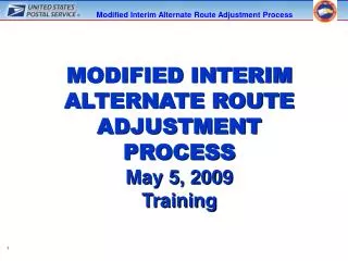
PilotageThings To Consider • Altitude • Mag Crs 0 to 179 = Odd + 500 • Mag Crs 180 to 359 = Even + 500 B A What's the rule?
8,500 ft MSL 7,500 ft MSL 180° - 359° Even Thousands + 500 ft 0° - 179° Odd Thousands + 500 ft Above 3,000 ft AGL Magnetic Course Dead Reckoning (DR)VFR Cruising Altitude Rules Jeppesen Sanderson, Inc. 1998 All Rights Reserved Guided Flight Discovery Private Pilot Manual
Dead Reckoning (DR)Flight Planning Process • Check the Weather • Select a Route • Choose a VFR Cruising Altitude Magnetic Course When flying course 175 and for wind correction, Flying heading 185. What is flight altitude?
Magnetic Course: 008° Magnetic Heading: 355° Correct VFR Cruising Altitude: Odd Thousand Plus 500 Feet WIND Dead Reckoning (DR)Magnetic Course / Cruising Altitude Jeppesen Sanderson, Inc. 1998 All Rights Reserved Guided Flight Discovery Private Pilot Manual
Dead Reckoning (DR)Flight Planning Process • Check the Weather
ข่าวอากาศ • โดยเฉพาะความเร็วลมและอุณหภูมิ • ใช้ในการหา Performance ของเครื่อง ได้แก่ VR, V1, V2, Vx, Vy, ระยะทางวิ่งขึ้น, ระยะทางร่อนลง, ขีดความสามารถของอุปกรณ์เครื่องวัดประกอบการบินที่มีสามารถเข้าสภาพอากาศได้หรือไม่ ข่าวอากาศได้จาก • METAR • TAF
Dead Reckoning (DR)Flight Planning Process • Check the Weather • Select a Route Consider all the factors! Checkpoints - Performance - Airspace - Fuel
Dead Reckoning (DR)Flight Planning Process • Check the Weather • Select a Route • Choose a VFR Cruising Altitude • Consider Fuel Requirements DAY NIGHT
การคำนวณจำนวนน้ำมัน Normal planning • When planning to an intended destination with alternate, the minimum amount of fuel to be on board the aircraft is the Minimum Ramp (Block) Fuel = Taxi Fuel + Trip Fuel + Contingency Fuel + Alternate Fuel + Final Reserve Fuel.
การคำนวณจำนวนน้ำมัน • Ramp (block) fuel = The total fuel on board the aircraft before starting engines. • Taxi fuel = A standard quantity to cover APU consumption, engine start, and ground maneuvers until a start of takeoff. • Takeoff fuel = Ramp fuel minus taxi fuel.
การคำนวณจำนวนน้ำมัน • Trip fuel = The fuel required to fly from the aerodrome of departure to the planned destination, based on planned operating conditions. This amount shall include fuel for takeoff, climb following a normally used SID giving longest distance, normal cruise, descent to initial approach fix, approach to the least favorable runway and landing.
การคำนวณจำนวนน้ำมัน • Contingency Fuel (CF) = Fuel required to cover deviations during flight from the “Planned operating conditions” as well as to provide operational flexibility in case of inflight malfunction. When planning a flight, the CF shall be 5% of the planned trip fuel. Be reduced to a minimum of 3% of the planned trip fuel, provided an en route alternate is available
การคำนวณจำนวนน้ำมัน • An en route alternate used for planning with reduced Contingency Fuel (CF) is an aerodrome which should be located within a circle with a radius equal to 20% of the total flight plan distance, the center of which lies on the planned route at a distance from destination 25% of the total flight plan distance, or 20% of the total flight plan distance plus 50 nm, whichever is greater.
การคำนวณจำนวนน้ำมัน • Alternate fuel = The fuel required to fly from the planned destination to the respective alternate, based on the planned operating conditions. The alternate fuel will include fuel from the start of a missed approach following a normally used SID giving the longest distance, Climb, Long-Range Cruise, descent to main navaid, and approach to the least favorable runway and landing at alternate.
การคำนวณจำนวนน้ำมัน • Final reserve fuel = Fuel required to fly for 30 min (Turbo Prop : 45 min) above the alternate aerodrome (or the destination when no alternate required) at: 1. Holding speed 2. 1500 ft ISA 3. Estimated weight.
ATC DETAIL • AIP: AERODROME INFORMATION PUBLISHCATION
Nav Log Dead Reckoning (DR)Flight Planning Process • Check the Weather • Select a Route • Choose a VFR Cruising Altitude • Consider Fuel Requirements • Prepare the Nav Log
C D G F H I B • Route Column: Departure, Reporting Point, Turning Point, Check Point, Destination • NAV Column: Freq & Code • Report Column: RPT Call Sign • MAG Heading Column: Magnetic Course & Drift • Distance Section: Total Distance, LEG / Remain • ETE/EST Total Column: Estimate Time En-Route • ETA / ATA :Estimate Arrival / Actual Time Arrival • Ground Speed Column: EST.GS • Fuel Section: Total AMT Fuel, EST LEG/Remain, Actual Fuel Remain • Position Report • Destination Airport Information A E J
Emergency Field Section • GCI or UHF/DF Station Section: Location, Callsign • Takeoff Data Section • Miscellaneous Data Section
การคำนวณหาค่าต่างๆ ตาม Flight plan • Heading • Speed • Time
หลักการบินเดินทางระยะสูงปานกลาง (Medium Level Navigation • ระยะสูงประมาณ 8,000 – 10,000 ฟุต
การเตรียมการก่อนการบินการเตรียมการก่อนการบิน • การเตรียมแผนที่ : ความกว้างของแผนที่ อย่างน้อย 40 NM จากเส้นทางบินและครอบคลุมพื้นที่ทั้งหมดตลอดเส้นทางบิน • เส้นทางบิน (Track) ลาก Track ลงบนแผนที่ ควรใช้สีดำหรือสีน้ำเงิน • ลากจากสนามบินต้นทางไปยัง Turning Point จุดแรก • ถ้า Turning Point ไม่มีเครื่องช่วยในการเดินอากาศติดตั้งอยู่ให้ใช้รัศมีวงเลี้ยว 1 ½ NM ที่ปลายสุดของ Track • ถ้า Turning Point มีเครื่องช่วยในการเดินอากาศติดตั้งอยู่การลาก Track ผ่าน Turning Point จะไม่มี Turning Radius
เส้นทางบิน (Track) NDB NO Turning Radius Visual Turning Point (Town) 1 ½ Turning Radius
ระยะทาง (Distance) • วัดระยะทางจากสนามบินต้นทาง ถึงสนามบินปลายทาง โดยแบ่งเป็นช่องๆละ 10 NM และ Mark ด้านนอกของ Track • ระยะทางของ Track ตรง Turning Point ที่มีเครื่องช่วยเดินอากาศติดตั้งอยู่ จะเพิ่มระยะทางจำนวน 1 NM ต่อมุมที่เปลี่ยนแปลง ๔๐ องศา
ระยะทาง (Distance) NDB 100º Track Change 2 ½ NM added to distance 130 120 150 110 160 100 Visual Turning Point (Town) 170 180 1 ½ Turning Radius 190 60 50 40 30 20 10
ทิศทาง (Direction) • วัดจากค่าเฉลี่ยของแต่ละขา เป็น Magnetic Tracks แล้วเขียนไว้ใน course arrow ทางด้านขวาของแต่ละขา ด้วยสีน้ำเงิน 360 0:45 3500 22 23
ระยะสูงปลอดภัย (Safety Heights) • ระยะสูงปลอดภัย (Safety Heights) • จะคิดแต่ละขาและแสดงลงใน Course Arrow • Aerodrome Control Boundaries • Check Points • ชัดเจน สังเกตได้ง่าย และอยู่ใกล้ Track
การศึกษาข่าวอากาศและการส่ง Flight Plan • ตรวจสอบสภาพอากาศ ความเร็วลม ฐานเมฆ ทัศนวิสัยของสนามบินต้นทาง • ตรวจสอบสภาพอากาศ ความเร็วลม ฐานเมฆ ทัศนวิสัย ตามเส้นทางบิน • ตรวจสอบสภาพอากาศ ความเร็วลม ฐานเมฆ ทัศนวิสัย ของสนามบินปลายทางและสนามบินสำรอง • ทำแผนการบินและส่งแผนการบินล่วงหน้าอย่างน้อย ๑ ชั่งโมง
ขั้นตอนการบิน (INFLIGHT PROCEDURE) • การไต่ • การบินระดับ • จุดเลี้ยว (TURNING POINT) • การลดระยะสูง (DESCENT PROCEDURE)
การไต่ • จับเวลาตั้งแต่ปล่อย BRAKES • AFTER TAKE – OFF OUTBOUND HEADING ตาม TRACK • รักษา A/S ไต่
การบินระดับ • รักษาความเร็วเดินทาง • ทำ CLEAR CHECK C (COMPASS) L (LOG) E (ENGINE) A (ALTIMETER) R (RADIO)
จุดเลี้ยว (TURNING POINT) • SET HEADING ขาต่อไป • REPORT POSITION • CHECK ETA • เลี้ยวถือ HEADING ใหม่ • แก้ไข ETA • ทำ CLEAR CHECK
การลดระยะสูง (DESCENT PROCEDURE) • ขออนุญาต ATC • ทำ BEFORE DESCENT CHECK
Lost Procedures What should you do? Where are you? Why are you lost?
Lost Procedures Remember the 5 Cs? CLIMB COMMUNICATE CONFESS COMPLY CONSERVE
CLIMB • ไต่หาความสูงเพื่อตรวจสอบจุด Check Point จุดสุดท้าย • มองหา Land Mark เปรียบเทียบกับสัญญลักษณ์ในแผนที่ • Check Compass • Check Time • COMMUNICATE • ติดต่อศูนย์ควบคุมการบิน Identify by SQ. • CONFESS • รายงานสถานการณ์ ข้อขัดข้อง ปัญหา และขอคำแนะนำ • COMPLY • ปฏิบัติตามคำแนะนำ • CONSERVE • ถ้าทุกอย่างไม่ประสบความสำเร็จ ให้เตรียมตัว Force ในพื้นที่ที่เหมาะสม
การวิเคราะห์ และการอ่านแผนที่ • พื้นที่โดยทั่วไป • ความสูงชันของพื้นที่ • ชายฝั่งทะเล และพื้นน้ำ • พื้นที่เกษตรกรรม และเพาะปลูก • เส้นทางคมนาคม และการติดต่อสื่อสาร • พื้นที่ที่ก่อสร้างขึ้นเป็นพิเศษ
การอ่านแผนที่ • การรู้ทิศทาง • การรู้ระยะทาง • การแปลความหมายของพื้นที่ • การเลือกที่หมาย
One – In – Sixty Rule 60 NM 1 องศา A 60 NM 1 NM
Distance off Correction angle to parallel X 1/60 = Distance flown Distance off Correction angle to converge X 1/60 = Distance to fly การนำไปใช้งาน Correction to parallel C Correction to converge Distance off A B Distance flown Distance to fly
Distance off Correction angle to parallel X 1/60 = Distance flown วิธีทำ เวลา = ? เวลา 02:10 A B 15 NM 2 NM HDG 138 Correction to converge HDG 150 C Correction to parallel เวลา 02:22 Distance off Correction angle to parallel = X 60 Distance flown 2*60 = = 8 องศา 15
Correction angle to parallel = 8 องศา HDG เดิม 150 HDG ใหม่ 138 ต่างกัน 12 องศา แสดงว่า Correction angle to converge= 12-8 = 4 องศา Distance off Correction angle to converge X 1/60 = จาก Distance to fly Distance offX 60 Distance to fly= Correction angle to converge 2*60 = 4 = 30 NM
ระยะทาง 15 NM ใช้เวลา 12 นาที ระยะทาง 30 NM ใช้เวลา 24 นาที ดังนั้น บ.จะกลับเข้า Track เวลา 0222+24 = 0246 Ans
Time to Station = Time for Bearing Change (minutes)×60 Degrees of Bearing Change • Distance to Station = Time for Bearing Change (minutes)×60 Degrees of Bearing Change
การคำนวณ TAS • Wind effect Effect on GS Effect on Drift
Map Reading • It is the identification of landmarks from their representation on a chart and therefore utilization of this information to fix the position of the aircraft or to establish lines of position.
Advantages and Limitation of Map Reading Advantages • The best means of checking dead reckoning • No fix is more precise than a positive identification of an accurately mapped landmark. Limitation • It cannot be used when the ground is obscured by clouds or when flying over water • Landmarks cannot always be readily identified on a chart such as at night or if the chart is incomplete or inaccurate.