Download
1 / 10
100 likes | 241 Views
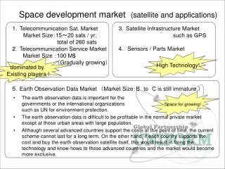
Space development market (satellite and applications). The earth observation data is important for the governments or the international organizations such as UN for environment protection.

E N D
Space development market (satellite and applications) The earth observation data is important for the governments or the international organizations such as UN for environment protection. The earth observation data is difficult to be profitable in the normal private market except at those urban areas with large population. Although several advanced countries support the costs at this point of time, the current scheme cannot last for a long term. On the other hand, if each country supports the cost and buy the earth observation satellite itself, this would result in fixing the technology and know-hows to those advanced countries and the market would become more exclusive. 3.Satellite Infrastructure Market such as GPS 4. Sensors / Parts Market 1.Telecommunication Sat. Market Market Size:15~20 sats / yr: total of 260 sats 2.Telecommunication Service Market Market Size :100 M$ (Gradually growing) High Technology! dominated by Existing players ! 5.Earth Observation Data Market (Market Size:BtoC is still immature.) Space for growing!
Now100-150 55 10 Future 50 100 50 (50 years) Seller countries Purchaser countries Space Developed Countries (competitive countries) Space Developing Countries Free user countries Space Developed Countries (mutual-beneficial countries) User→Operator→Analyst Space Utilization Promotion Countries Educational tools Fundamental science programs Basic education of science and aerospace technology Can-sat / Hybrid rocket programs General education of project management Cube-sat / Stratosphere balloon programs Specialized education of space-related technology and knowledge Industry tools Big project ( Hayabusa, BepiColombo, etc.) OJT program of space technology and project management Free access to the common data platform Inter ground station collaboration / constellation operation Communalize satellite technology Communalize data platform
The strategy of small satellite R&D Low cost and high frequency experimental opportunity at the space High value added, but total sales is not too much. Need high technology for global competitiveness All of satellites made by domestic production. High ability but low cost Suitable for private company Only onesatellite Good business modelfor the satellite sale. Japan vs Foreign country Technologyis secret Poor profits in the field of the satellite sales. Basic technology transfer, export of efficient parts Reduction international contribution cost. Single function,hodoyoshi cost, mass production Open technology Win-Win Total business model of the space development collaboration Call for the capital from the new comer for the field of non-profit market (ex. earth observation), and reduce the load of the developed countries.
Past Now Future The usage of satellite will be increasing. Big satellite Some component made by developing countries. More and more component made by developing countries. Big satellite made by Developed country (100%) Small satellite Non The technique of the satellite monopolized by developed country New comer sturdy the technology of the satellite More and more new comers sturdy the technology of the satellite
UNIFORM Project (1) Satellite(Flight segment) Training Available (2) Ground Station Training Available (3) Data Platform End Users Please Use Welcome to Join 5
Schedule of the UNIFORM Project 2010 2011 2012 2013 2014 2015 FY Cubesat, deployed from ISS Satellite RAIKO Launch 50kg satellite, will be launched by HII-A UNIFORM-1 Launch EM FM UNIFORM-2 Available forTraining Purpose FM UNIFORM-3 FM Ground Station Design Development & Testing OperateUNIFORM-1 6
The strategy of Space education and Capacity building The export of the space education promotes the personal exchanges between our countries. And it is useful for the formation of strong networks to the industrialization in the future. Free technology transfer and corroboration of capacity building are useful for the construction of worldwide satellite infrastructure. Coverage in Process Manager Policy planning Human networks Engineer System designing Plan Design Purchase Components Assembly Integration Test UNIFORM Introduction Only Supervising Technician Manufacturing Labor High school, University, post graduate students education
Japan already have the AMeDAS (Automated Meteorological Data Acquisition System) AMeDAS is composed by 1,300 points of the sensor stations, and ground communication network infrastructures. The number of the stations are enough to the weather forecast, but it is not enough to the forecast of the sediment disaster. Store & Forward system provide to us higher density sensor stations networks. Hodoyoshi 3 Hodoyoshi 4 Ground station Sensors stations Future Plan in Store & Forward
Quasi-Zenith Satellite System (2018~) For disaster monitoring, small satellite constellations and QZSS are very useful • Because of sub-meter and centimeter level augmentation signal are serviced from QZSS satellites, the system can help to find the detail positions of the sensor stations. • Because of Quasi-Zenith orbit, the signal from the QZSS satellite is easy to detect to the receiver in the mountains and jungle in buildings. • Wakayama University and Geospatial Information Authority of Japan collaborate to use QZSS, GPS-based Control Station and S&F, as a monitoring system • The QZSS system on the car navigation systems will show the real time traffic situations. Real-time traffic information is crucial for planning rescue activity at the time of disaster